Related Research Articles

The Coral Sea Islands Territory is an external territory of Australia which comprises a group of small and mostly uninhabited tropical islands and reefs in the Coral Sea, north-east of Queensland, Australia. The only inhabited island is Willis Island. The territory covers 780,000 km2 (301,160 sq mi), most of which is ocean, extending east and south from the outer edge of the Great Barrier Reef and includes Heralds Beacon Island, Osprey Reef, the Willis Group and fifteen other reef/island groups. Cato Island is the highest point in the Territory.

Malacca Strait is a narrow stretch of water, 500 mi long and from 40 to 155 mi wide, located between the Indonesian island of Sumatra to the southwest and the Malay Peninsula to the northeast, connecting the Andaman Sea with the Singapore Strait and the South China Sea. As the main shipping channel between the Indian Ocean and South China Sea, it is one of the most important shipping lanes in the world. It is named after the Phyllanthus emblica, which known by the locals as the Malaka tree, grown in coastal regions alongside the strait.

The Karimata Strait is a wide strait that connects the South China Sea to the Java Sea, separating the Indonesian islands of Belitung to the west and Borneo (Kalimantan) to the east. It is the widest strait between the South China Sea and the Java Sea, but its numerous islands and reefs reduce its navigability. Its weather and current is influenced by the annual southeast and northwest monsoon.

Lampung, officially the Province of Lampung, is a province of Indonesia. It is located on the southern tip of the island of Sumatra. It has a short border with the province of Bengkulu to the northwest, and a longer border with the province of South Sumatra to the north, as well a maritime border with the province of Banten and Jakarta to the east. It is the original home of the Lampung people, who speak their own language, and possess their own written script. Its capital is Bandar Lampung.

The Bangka Belitung Islands is a province of Indonesia. Situated off the southeastern coast of Sumatra, the province comprises two main land masses — Bangka and Belitung — and numerous smaller islands. Bangka Belitung is bordered by the Bangka Strait to the west, the Natuna Sea to the north, the Java Sea is to the south and the Karimata Strait to the east. The province's capital and largest city is Pangkalpinang. The province shares maritime borders with South Sumatra to the west, Riau Islands to the north, Banten, the Special Capital Region of Jakarta, West Java, and Central Java to the south, and West Kalimantan to the east. Bangka Belitung covers a land area of 16,690.54 km2 (6,444.25 sq mi) and had a population of 1,455,678 according to the 2020 census; the official estimate as at mid 2022 was 1,494,621.

Natuna Regency is an islands regency located in the northernmost part of the Province of Riau Islands, Indonesia. It contains at least 154 islands, of which 127 of them are reported as uninhabited. This archipelago, with a land area of 1,978.31 km2 out of a total area of 264,198.37 km2 area, contains 15 districts, including the island district of Pulau Laut, Bunguran/Greater Natuna Island, the island district of Pulau Tiga, the island district of Midai, the island district of Subi, and the island district of Serasan.

Nias is an island located off the western coast of Sumatra, Indonesia. Nias is also the name of the archipelago of which the island is the centre, but also includes the Batu Islands to the south-east and the small Hinako Islands to the west. Nias Island covers an area of 5,625.0 km2 (2,171.8 sq mi). It is mostly a lowland area rising to around 800 m (2,600 ft) above sea level. There were 756,338 inhabitants on the island at the 2010 Census; at the 2015 Intermediate Census this had risen to 798,506 and the 2020 Census resulted in a total of 880,550. The official estimate as at mid 2022 was 902,632.
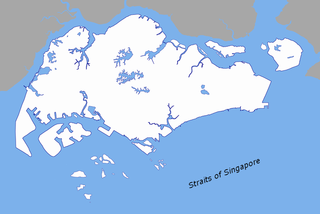
The Singapore Strait is a 113 km-long (70 mi), 19 km-wide (12 mi) strait between the Strait of Malacca in the west and the South China Sea in the east. Singapore is on the north of the channel, and the Indonesian Riau Islands are on the south. The two countries share a maritime border along the strait.
The Tropical Rainforest Heritage of Sumatra site was inscribed as a UNESCO World Heritage Site in 2004. It comprises three Indonesian national parks on the island of Sumatra: Gunung Leuser National Park, Kerinci Seblat National Park and the Bukit Barisan Selatan National Park. The site is listed under Criteria vii - outstanding scenic beauty; ix- an outstanding example representing significant on-going ecological and biological processes; and x- contains the most important and significant natural habitats for in-situ conservation. The Tropical Rainforest Heritage of Sumatra has been placed on the Danger List since 2011 to help overcome threats posed by poaching, illegal logging, agricultural encroachment, and plans to build roads through the site.

Raja Ampat, or the Four Kings, is an archipelago located off of the northwest tip of Bird's Head Peninsula, Southwest Papua province, Indonesia. It comprises over 1,500 small islands, cays, and shoals around the four main islands of Misool, Salawati, Batanta, and Waigeo, and the smaller island of Kofiau.

South Pagai is one of the Mentawai Islands of the west coast of Sumatra in Indonesia. The island is south of North Pagai Island. The population figure given for South Pagai refers to South Pagai District alone. The largely unpopulated south portion of Sikakap District covers the southern part of North Pagai Island and the northern part of South Pagai Island, as well as various small islands in the strait between the two.
Brother Island, Brothers Island, etc. may refer to any of several islands and island groups around the world, including
Pandang Island is a small island in the Strait of Malacca, off the coast of Sumatra, about 47 km from Tanjungbalai and 10 km north of Salahnama Island. It belongs to Indonesia.
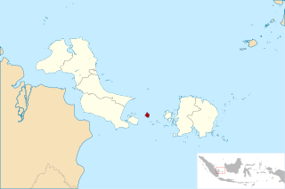
Little Iyu Island is a small island in the Strait of Malacca, about 4.5 km north-west of Little Karimun Island, about 50 km west of Singapore, and about 800 m north-east of the Great Iyu Island. The two Iyu islets are known as The Brothers.
Great Iyu Island is a small uninhabited island in the Strait of Malacca, about 4.5 km north-west of Little Karimun, about 50 km west of Singapore, and about 800 m south-west of Little Iyu Island. The two Iyu islets are known as The Brothers. The island belongs to the Karimun Regency of the Riau Islands Province of Indonesia.
Rondo Island is Indonesia's northernmost territory, located in the Andaman Sea, with a 0.650 km2 area 35m above sea level. The island is one of the outlying islands of Indonesia in the Aceh province of the Sumatra region. It is administratively part of Ujung Bau village in the Sukakarya District of Sabang City, whose administration center is on Weh Island, south of Rondo. Rondo is 50 km offshore from Indonesia's Sumatra mainland. This otherwise uninhabited island, accessible only by boat, has an Indonesian military outpost with a heliport and blue-roofed barracks, an adjacent lighthouse complex with a red-roofed lighthouse keeper's house and a white skeletal lighthouse topped with a viewing gallery and lantern.

The Thousand Islands are a chain of islands to the north of Jakarta's coast. It forms the only regency of Special Capital Region of Jakarta, the metropolitan province of Indonesia. It consists of a string of 342 islands stretching 45 km (28 mi) north into the Java Sea at West Jakarta Bay and in fact are located to the north of Banten Province. Pramuka Island is the regency seat. The islands, along with North Jakarta City, are the only administrative divisions of Jakarta Spacial Capital Region with a coastline.
Pongok, sometimes known as Liat, is an Indonesian island which is part of the Pongok Islands District of the South Bangka Regency, Bangka Belitung Province. It comprises over 95% of the district's area and most of its population, with an area of 48.3 square km. It is the 5th largest island in the province, being far smaller than Bangka and Belitung in addition to the islands of Lepar and Mendanau.
References
- 1 2 3 4 5 6 J. W. Reed and J. W. King (1867), The China sea directory , pages 219–220. British Admiralty Hydrographics Office.
- 1 2 3 4 Wikimapia, Kepulauan Rukan. Accessed on 2012-07-03.
- 1 2 3 4 5 6 7 8 Sailing Directions (Enroute), Strait of Malacca and Sumatra National Geospatial Intelligence Agency, USA. Archived 2014-03-13 at the Wayback Machine
- ↑ Rukan Selatan Light . Lighthouse Digest website, Accessed on 2012-07-03.
0°34′36″N103°46′23″E / 0.576635°N 103.773148°E
 | This Riau Islands location article is a stub. You can help Wikipedia by expanding it. |