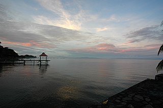
Lake Nicaragua or Cocibolca or Granada is a freshwater lake in Nicaragua. Of tectonic origin and with an area of 8,264 km2 (3,191 sq mi), it is the largest fresh water lake in Central America, the 19th largest lake in the world and the tenth largest in the Americas, slightly smaller than Lake Titicaca. With an elevation of 32.7 metres (107 ft) above sea level, the lake reaches a depth of 26 metres (85 ft). The intermittent Tipitapa River feeds Lake Nicaragua when Lake Managua has high water. Lake Cocibolca is between two other bodies of water, on top is Lake Xolotlán and below is the San Juan River. These body of waters complete the largest International Drainage Basin in Central America.

Los Lagos Region is one of Chile's 16 regions, which are first order administrative divisions, and comprises four provinces: Chiloé, Llanquihue, Osorno and Palena. The region contains the country's second-largest island, Chiloé, and the second-largest lake, Llanquihue. Its capital is Puerto Montt; other important cities include Osorno, Castro, Ancud, and Puerto Varas. Los Lagos Region is considered part of Patagonia.

Osorno Province is one of the four provinces in the southern Chilean region of Los Lagos (X). The province has an area of 9,223.7 km2 (3,561 sq mi) and a population of 221,496 distributed across seven communes. The provincial capital is the city of Osorno.

Puyehue National Park is in the Andes mountain range, in Los Ríos and Los Lagos regions of Chile formerly referred to as the 10th region. The park boast 220,000 acres of natural thermal springs, volcanoes, and evergreen forests, after having been expanded in 1950 and 1981. The park is Chile's most visited national park with 400,000 people enjoying it each year. Puyehue National Park forms part of the Reserve of Temperate Rainy Forest Biospheres of the Southern Andes. Chile Route 215 passes through the park, which connects with the Argentine Route 231 via Cardenal Antonio Samoré Pass.

Puntiagudo-Cordón Cenizos is a snow-capped volcanic chain located in the Andes, in Los Lagos Region of Chile, near Volcán Osorno. It lies between Rupanco Lake and Todos los Santos Lake. "Volcán Puntiagudo" is a stratovolcano with a prominent 2,493 m high sharp-pointed summit that results from glacial dissection and gets its name from this feature. According to locals, the Puntiagudo volcano lost some of its sharp point in the earthquake of 1960. So the volcano was more pointed than it is today. Puntiagudo is also given the name Cerro Cenizas.

Yelcho Lake is a large fjord-shaped lake located in Chilean Patagonia, in southern Palena province of Los Lagos Region, Chile. The lake receives the waters of the Futaleufu River at its southern tip, near the tiny settlement of Puerto Ramirez. The river then flows northward through mountainous and glaciated terrain, until it outflows via the Yelcho River north-west and empties into Gulf of Corcovado, near Chaitén. The lake is a popular destination for fly fishing, and several lodges and hotels operate on its shores. Yelcho Lake is most frequently accessed via the town of Chaitén to the north. Two small commercial airlines operate daily flights from Puerto Montt. Another option is ferry service direct from Puerto Montt, the bimodal ferry service from the town of Hornopiren, or direct from the port of Quellón on the island of Chiloe on the other side of the Gulf of Corcovado. Traffic on the Carretera Austral along the western shore of Yelcho Lake was interrupted in December 2017 due to a mudslide in the settlement of Villa Santa Lucía, which killed 22 people. The road reopened in February 2018.
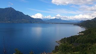
Lake Ranco is situated in the Ranco Province of Los Lagos Region in Chile. Covering an area of 442 km2, it is the largest lake in the Los Ríos Region and the fourth largest in Chile. It has approximately 25 islands and islets, but only 4 are currently inhabited.

Puyehue Lake, is an Andean piedmont lake on the border of Los Lagos Region with Los Ríos Region of Chile.
Grey Lake is a glacially fed lake in Torres del Paine National Park, southern Chile.

Lago di Mergozzo is a small sub-alpine lake in northern Italy just to the west of Lago Maggiore and north of Lago d'Orta, at the mouth of the Val d’Ossola in the province of Verbano Cusio Ossola, Piedmont.

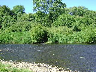
The Bueno River is a river in southern Chile. It originates in Ranco Lake and like most of Chile rivers it drains into the Pacific Ocean at the southern boundary of the Valdivian Coastal Reserve. Its lower flow forms the border between Osorno Province and Ranco Province. Traditionally, it marks also the northern boundary of the indigenous Huilliche territory known as Futahuillimapu. The river passes through Río Bueno commune and city that takes name from the river.
Entre Lagos is the main town of Puyehue commune in Osorno Province of Los Lagos Region, Chile. It is 46 km (29 mi) east of Osorno, next to the entrance of the Pilmaiquén River at the western end of Puyehue Lake. It is the only town of any size on the lake.
Puyehue is a commune in Chile located in Osorno Province of Los Lagos Region. It is bordered to the south by Rupanco Lake, to the east by the Andes and Argentina, to the north by Puyehue Lake and to the west by Osorno commune. Cardenal Antonio Samoré Pass that links the Los Lagos Region to Argentina lies in the eastern tip of the commune. The comune is administered by Entre Lagos, the main town in Puyehue.
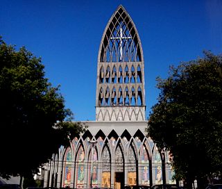
The Roman Catholic Diocese of Osorno is a suffragan diocese of the archdiocese of Puerto Montt, in Chile. The diocese was established on 15 November 1955 by Pope Pius XII by means of the papal bull Christianorum qui in Diocesibus.

Rahue River is a river of Chile located in Los Lagos Region. It rises at the western end of the Rupanco Lake. In its middle course, the river flows through the city of Osorno in a north-south direction. Rahue river empties into the Bueno River 40 km inland from the Pacific Ocean.

The following outline is provided as an overview of and topical guide to Nicaragua:

The Chilean Lake District is a zone in Southern Chile defined by its many lakes in the Andean foothills. The term is primarily used in tourism literature and advertising, in Chile Zona Sur is preferred as a geographical concept. The Chilean Lake District includes the cities of Temuco, Villarrica, Pucón, Valdivia, Osorno, Entre Lagos (Puyehue), Puerto Octay, Frutillar, Puerto Varas and Puerto Montt.
Juan Kemp Airport, is an airstrip on the southern shore of Rupanco Lake in the Los Lagos Region of Chile. The nearest town is Entre Lagos, 30 kilometres (19 mi) northwest on neighboring Puyehue Lake.
Damas River or de Las Damas River is a river of Chile located in Los Lagos Region. The river originates at an area known as Quema del Buey in the commune of Entre Lagos between Puyehue and Rupanco Lake. The river ends at its convergence with Rahue River. Damas River traverses the city of Osorno from east to west and separates the neighborhood of Pilauco from the rest of the city.

The Aguas Calientes Hot Springs is a series of hot springs located 76 kilometers near Route 215-CH east of Osorno in Los Lagos Region of southern Chile.

