
The Bolognesi Province is one of 20 provinces of the Ancash Region of Peru.

Aquia District is one of fifteen districts of the province Bolognesi in Peru.
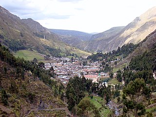
Huallanca or Wallanka is a district of the Bolognesi Province in the Ancash Region of Peru.

Tuco,Tuku,Tucu or Huanaco Punta is a mountain in the Andes in South America. Its summit is 5,479 m (17,976 ft)) high and it is one of the southernmost peaks in the snow-capped Cordillera Blanca in northwestern central Peru. Tuco is located in the Ancash Region, Bolognesi Province, Aquia District and in the Recuay Province, Catac District. It is situated northeast of Caullaraju, between Challhua in the west and Pastoruri in the east.

The Huallanca mountain range (possibly from Quechua, wallanka mountain range; a cactus plant ; also called Chaupi Janca or Shicra Shicra lies in the Andes of Peru. It is located in the Ancash Region, Bolognesi Province. The Huallanca mountain range is a small range southeast of the Cordillera Blanca and north of the Huayhuash mountain range extending between 9°52' and 10°03'S and 76°58' and 77°04'W for about 19 km in a northeasterly direction.
Huallanca, also known as Burro, is a 5,470 m (17,950 ft)) high mountain in the Andes of Peru. It is the highest peak in the Huallanca mountain range. Huallanca is located in the Ancash Region, Bolognesi Province, in the districts of Aquia and Huallanca. It is situated in the northern half of the range, southeast of the Yanashallash pass and the peaks of Tankan, Ch'uspi and Tankanqucha. Kuntur Wayi lies southwest of it. Winchus 4,795 m (15,732 ft)) is the peak west of Wallanka at the Tuna Kancha valley.
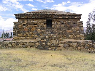
Willkawayin is an archaeological site in Peru. It is located in the Ancash Region, Huaraz Province, Independencia District, in the village of Paria. It is situated at a height of about 3,400 m (11,200 ft).
Pumahuaín is a 5,008-metre-high (16,430 ft) mountain in the southern part of the Cordillera Blanca in the Andes of Peru. It is situated in the Ancash Region, Recuay Province, Catac District. Puma Wayin lies southwest of Mururahu and Kunkush and northwest of Pukarahu.

Kuntur Wayi or Kuntur Wayin is a 5,171-metre-high (16,965 ft) mountain in the Wallanka mountain range in the Andes of Peru. It is situated in the Ancash Region, Bolognesi Province, on the border of the districts of Aquia and Huallanca. Kuntur Wayi lies east of the Minapata valley, southwest of Kunkush, south of Wallanka and southeast of Minapata.
Munti Wayi is a 4,902-metre-high (16,083 ft) mountain in the Cordillera Blanca in the Andes of Peru. It is located in the Ancash Region, Bolognesi Province, Aquia District. It lies northeast of Rahu Kutaq and southeast of Pastu Ruri.
Puka Qaqa is a mountain south of the Wallanka mountain range in the Andes of Peru which reaches an altitude of approximately 4,800 m (15,700 ft). It is located in the Ancash Region, Bolognesi Province, Huasta District. Puka Qaqa lies at the Pampa Wayi valley, southwest of a lake named Kunturqucha.
Kuntur Wayi or Kuntur Wayin may refer to:
Puma Wayin is a mountain in the Andes of Peru which reaches a height of approximately 4,400 m (14,436 ft). It is located in the Ancash Region, Bolognesi Province, Huallanca District, east of Ismu Cruz.
Puma Wayin is a mountain in the Cordillera Negra in the Andes of Peru which reaches a height of approximately 4,400 m (14,436 ft). It is located in the Ancash Region, Aija Province, La Merced District.
Rumi Wayin Punta is a mountain in the Andes of Peru which reaches a height of approximately 4,600 m (15,100 ft). It is located in the Ancash Region, Bolognesi Province, Chiquian District, southwest of Chiquian.
Kushuru is a mountain in the Andes of Peru which reaches an altitude of approximately 4,800 m (15,700 ft). It is located in the Ancash Region, Bolognesi Province, Huasta District. Kushuru lies south of the Pampa Wayi valley.
Chawpi Punta is a mountain in the Andes of Peru which reaches an altitude of approximately 4,600 m (15,100 ft). It is located in the Ancash Region, Bolognesi Province, Huasta District. Chawpi Punta lies at the Pampa Wayi valley, southwest of Puka Qaqa.
Muya Wayin is a mountain in the eastern extensions of the Wallanka mountain range in the Andes of Peru which reaches a height of approximately 4,600 m (15,092 ft). It is located in the Ancash Region, Bolognesi Province, Huallanca District. Muya Wayin lies on a ridge east of Wallanka, west of Yana Pukyu.
Waman Wayi is a mountain in the Andes of Peru which reaches a height of approximately 4,400 m (14,436 ft). It is located in the Ancash Region, Huari Province, San Marcos District.


