
Baripada is a city and a municipality in Mayurbhanj district in the state of Odisha, India. Located along the east bank of the Budhabalanga river, Baripada is the cultural centre of north Odisha. In recent years, it has emerged as an educational hub with the opening of numerous professional colleges.
Mayurbhanj district is one of the 30 districts in the Odisha state of eastern India. It holds the distinction of being the largest district in Odisha by area. The district's headquarters is located in Baripada, with other major towns including Rairangpur, Karanjia, and Bahalda. As of 2011, Mayurbhanj ranks as the third-most populous district in Odisha, following Ganjam and Cuttack.
Balasore, also known as Baleswar, is a city in the state of Odisha, about 215 km (134 mi) from the state capital Bhubaneswar and 300 km (186 mi) from Kolkata, in eastern India. It is the administrative headquarters of Balasore district and the largest city as well as health and educational hub of northern Odisha. It is best known for Chandipur beach. It is also called 'missile city'. The Indian Ballistic Missile Defence Programme's Integrated Test Range is located 18 km south of Balasore.

Rairangpur is a city and a tehsil in the Mayurbhanj district of the state of Odisha, India. It is located 287 kilometres from the state capital Bhubaneswar, 82 kilometres from the district headquarters of Baripada, and about 73 kilometres from Jamshedpur. Rairangpur is the second largest city in the Mayurbhanj district, a notable mining area of Odisha, producing iron-ore from the Gorumahisani, Badampahar, and Suleipat mines.
Balasore District, also known as Baleswar District, is an administrative district of Odisha state, in eastern India. Balasore is one of the coastal districts of Odisha and lies on the northernmost part of the state.
Jaleswar is a town located in the Balasore district of Odisha, in India. It consists of 144 villages, with four major areas: Bada Bazar, Nua Bazar, Station Bazar, and Purana Bazar. Jaleswar is considered one of the new municipalities in the state, and Jaleswar forms a state assembly constituency along with Balipal Block.
Mayurbhanj State Railway (MSR) was a 2 ft 6 in (762 mm) narrow gauge railway owned by Mayurbhanj State in British India.
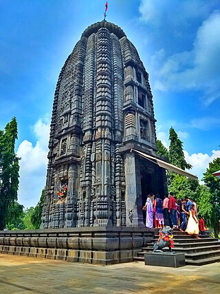
Jashipur is a town in Mayurbhanj district in the state of Odisha, India. The town is located in southwestern region of Simlipal National Park comprising diverse geographical valleys, forest lands and scores of ancient temples like Khiching temple and first headquarter of erstwhile Mayurbhanj state.
Betnoti is a small town in the Mayurbhanj district in the state of Odisha, India. It is the block headquarter of the Betnoti block. It is 26 kilometres (16 mi) from Baripada, the district headquarters of Mayurbhanj, and 194 kilometres (121 mi) from Bhubaneswar, the capital of Odisha.
Thakurmunda is a block headquarter and a small Town in Mayurbhanj district in the state of Odisha, India. Thakurmunda is referred as the largest block of mayurbhanj district having a radius of 40kms. The nearest city is Karanjia. Thakurmunda is a place to stay and tour the Mayurbhanj region. This region is home to Similipal, one of the most important wildlife parks of India. The national park comprises lush valleys, forest lands and scores of ancient temples.

The Kharagpur–Puri Line is a railway line connecting Kharagpur in the Indian state of West Bengal and Puri in Odisha. The total line can be divided into sections. The Kharagpur–Khurda Road portion of this line, which is a part of the Howrah–Chennai main line and Khurda Road - Puri portion.
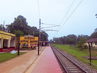
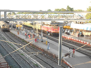
The Baripada Railway Station serves Baripada, the headquarters of Mayurbhanj district in the Indian state of Odisha.
Balasore railway station serves Balasore, Remuna, Chandipur, Bhograi in Balasore district and other districts like Mayurbhanj, Kendujhargarh and Bhadrak for boarding major trains like Duronto, Rajdhani, Shatabdi, Humsafar Express and many more trains that do not stop at Bhadrak station in the Indian state of Odisha.

Mayurbhanj State was one of the princely states of India during the British Raj. It was one of the largest states of the Eastern States Agency and one of the four salute states of the Orissa States Agency. The emblem of the state was two peacocks, for according to legend the ancestors of the rulers had originated from a peafowl's eyes.
Sindhekela is a town and a Notified Area Council in Balangir district in the Western Odisha region of Odisha India. Sindhekela is one of the business hub in Balangir district.

Utkal Sangeet Mahavidyalaya is a performing arts-cum-educational institution in Bhubaneswar, Odisha, India.

Rupsa Junction railway station is a railway station on the South Eastern Railway network in the state of Odisha, India. It serves Rupsa town. Its code is ROP. It has five platforms. Passenger, Express and Superfast trains halt at Rupsa Junction railway station.
Badajahata is a village in the Baleshwar district in Odisha in Eastern India with a population of 780. It is also known as Jahata Village. It is located about 10 km From Subarnareka River. The nearest town is Rupsa. The nearest Hospital is Rupsa Govt Hospital situated 4 km from the village.

State Highway 19 (Odisha) is a state highway of the Indian state of Odisha, connecting Balasore district to Mayurbhanj district through the mejor settlement Nilagiri, Udala and Baripada.

