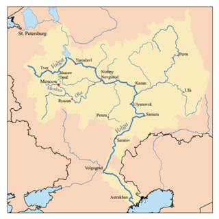
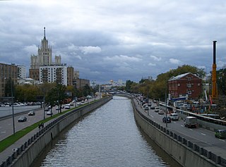
The Moskva River is a river of western Russia. It rises about 140 km (90 mi) west of Moscow, and flows roughly east through the Smolensk and Moscow Oblasts, passing through central Moscow. About 110 km (70 mi) south east of Moscow, at the city of Kolomna, it flows into the Oka River, itself a tributary of the Volga, which ultimately flows into the Caspian Sea.
The Yauza is a river in Moscow and Mytishchi, Russia, a tributary of the Moskva River. It originates in the Losiny Ostrov National Park northeast of Moscow, flows through Mytishchi, enters Moscow in the Medvedkovo District and flows through the city in an irregular, meandering, generally north-south direction. The Yauza joins the Moskva River in Tagansky District just west of Tagansky Hill, now marked by the Kotelnicheskaya Embankment tower. Valleys of the Yauza, from the MKAD beltway in the north to the Moscow-Yaroslavl railway west of Sokolniki Park, are protected as natural reserves.
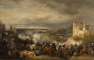
The Battle of Maloyaroslavets took place on 24 October 1812, between the Russians, under Marshal Mikhail Illarionovich Kutuzov, and part of the corps of Eugène de Beauharnais, Napoleon's stepson, under General Alexis Joseph Delzons which numbered about 20,000 strong.

The Pakhra River is a river in Moscow Oblast and the city of Moscow, Russia, a right tributary of the Moskva River. It is 135 km in length. The area of its basin is 2580 km². The Pakhra River freezes up in November–December and stays under the ice until the late March–April. Main tributaries: Mocha, Desna. Gorki Leninskiye and Podolsk stand on the Pakhra River.

The European route E 22 is one of the longest European routes. It has a length of about 5,320 km (3,310 mi). Many of the E-roads have been extended into Asia since the year 2000; the E 22 was extended on 24 June 2002.

Strogino, formerly known as Ostrogino (Острогино), is a district in North-Western Administrative Okrug of Moscow, Russia, located on the right bank of the Moskva River about 12 km west-northwest of central Moscow. An eponymous Moscow Metro station Strogino on the Arbatsko-Pokrovskaya Line was opened here on January 7, 2008. The Moscow Ring Road runs down the western border, and the Moskva River borders the district on the north and east. The area of the district is 18.643 square kilometres (7.198 sq mi). Population: 152,500
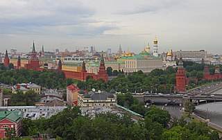
Kremlin Hill is one of the seven hills of Moscow. Altitude up to 145 m. The hill is situated in the city centre, at the confluence of the Moscow River and Neglinnaya River. The Red Square and the upland part of the Kitai-gorod are located on the hill.

The Autodrom Moscow is a race track located near Moscow, 13 km from Moscow Circuit Road and 31 km from the city center. The track is constructed in the Miachkovo Airport area which has been in use for motor racing since 2001. After the total reconstruction in 2005, it was the only racing facility in Russia until the Red Ring circuit has been opened in Siberia in 2007. The track design satisfies to FIA Grade III requirements. The raceway equipped with 18 pit boxes, 13×6 m each, race control tower with AMB time keeping system, grandstands for 2000 spectators and a small hotel.
The Tsytsin Main Moscow Botanical Garden of Academy of Sciences was founded in April 1945, and claims itself to be the largest botanical garden in Europe. It covers a territory of approximately 3.61 km², bordering the VDNKH Exhibition Center, and contains a live exhibition of more than twenty thousand different species of plants coming from various parts of the world. The garden also has a scientific research laboratory and contains a rosarium with twenty thousand rose bushes, a dendrarium (arboretum), an oak forest with the average age of the trees exceeding 100 years, a Japanese garden and a greenhouse of more than 5000 square meters.
Skhodnya River, also known as Sukhodnya, Vkhodnya, Vykhodnya and Vskhodnya is a river in the northwest of Moscow, the second largest tributary of the Moskva River. The length of the Skhodnya is 47 km. The area of its basin is 17,2 km². The Skhodnya originates near the village of Alabushevo and flows into the Moskva River near the Tushino Airfield. The Skhodnya River is connected with a derivational canal, which supplies water from the Volga River through the Khimki Reservoir to Moscow for sanitary irrigation.
Smolensky Metro Bridge is a steel arch bridge that spans Moskva River in Dorogomilovo District of Moscow, Russia. It is the first bridge built for the Moscow Metro in 1935–1937, designed by N.P.Polikarpov, P.K.Antonov and Yakovlev brothers. It is one of two bridges over Moskva River that are used exclusively by Metro (subway) trains, while the other Metro bridges combine road and rail.
Pekhorka River is a river in the Moscow Region in Russia, a left tributary of the Moskva River. Total length - 42 km, water catchment area - 513 km².
The Luzha River, a river in Kaluga Oblast in Russia, originates in Moscow Oblast. It is a right tributary of the Protva River. The Luzha has a length of 159 km (99 mi) and a drainage basin area of 1,400 km2 (540 sq mi). The Luzha freezes up in November and breaks up in April. The town of Maloyaroslavets, the site of an important battle in 1812 during the French invasion of Russia, is located on the Luzha River.

The Vorya River is a river in Moscow Oblast, Russia. It is a left tributary of the Klyazma River. It is 99 km in length, with a drainage basin of 1160 km².

The Embassy of the Republic of Italy in Moscow is the chief diplomatic mission of Italy in the Russian Federation. It is located at 5 Denezhny Lane in the Khamovniki District of Moscow.

The Desna River, is a river in Moscow Oblast, Russia. It is a left tributary of the Guslitsa River. It is 25 km in length. The Desna River freezes up in November–December and stays under the ice until April.
Obolensk (Оболенск) was a city in Russia, and in the medieval period one of the Upper Oka Principalities, situated at the Protva River.
The Smolensk–Moscow Upland is located in the Yaroslavl, Vladimir, Moscow and Smolensk regions of Russia, as well as the Vitebsk region of Belarus.

The Main Building of the Russian Defense Ministry is the headquarters of the Russian Ministry of Defense, located in Moscow, Russia.