The Arctic Archipelago, also known as the Canadian Arctic Archipelago, is a group of islands north of the Canadian mainland.
In archaeology, a ring ditch is a trench of circular or penannular plan, cut into bedrock. They are usually identified through aerial photography either as soil marks or cropmarks. When excavated, ring ditches are usually found to be the ploughed‐out remains of a round barrow where the barrow mound has completely disappeared, leaving only the infilled former quarry ditch. Both Neolithic and Bronze Age ring ditches have been discovered.
The Mamoré is a large river in Bolivia and Brazil which unites with the Beni to form the Madeira, one of the largest tributaries of the Amazon. It rises on the northern slope of the Sierra de Cochabamba, east of the city of Cochabamba, and is known as the Chimoré down to its junction with the Chapare. Its larger tributaries are the Chapare, Secure, Apere, and Yacuma from the west, and the Ichilo, Guapay, Ivari, Manique and Guapore from the east. Taking into account its length only, the Guapay should be considered the upper part of the Mamore; but it is shallow and obstructed, and carries a much smaller volume of water. The Guapore also rivals the Mamore in length and volume, having its source in the Parecis plateau, Mato Grosso, Brazil, a few miles from streams flowing north-ward to the Tapajos and Amazon, and southward to the Paraguay and Paraná rivers. The Mamore is interrupted by rapids a few miles above its junction with the Beni, but a railway 300 km long has been undertaken from below the rapids of the Madeira. Above the rapids the river is navigable to Chimore, at the foot of the sierra, and most of its tributaries are navigable for long distances. In 1874, Franz Keller gave the outflow of the Mamoré at mean water level, and not including the Guapore, as 41,459 cm3/sec, and the area of its drainage basin, also not including the Guapore, as 24,299 km2.

The Ulúa River is a river in western Honduras. It rises in the central mountainous area of the country close to La Paz and runs 240 kilometres (150 mi) approximately due northwards to the east end of the Gulf of Honduras at 15°55′N87°43′W. En route, it is joined by the Sulaco River, the Jicatuyo River, the Otoro River and the Chamelecón River.

The Yacuma River is a river in Bolivia.
Monda River, also Monga River and Manga River is a river in the area of Sabá, Colón Department, Honduras.

Santa Rita de Cássia is a Brazilian municipality in the state of Bahia. On July 1, 2008 the town's population was estimated as 27.224 inhabitants.
Castronuevo is a municipality in the province of Zamora, Castile and León, Spain. According to the 2009 census (INE), the municipality has a population of 312 inhabitants.
Ucero is a municipality located in the province of Soria, Castile and León, Spain. According to the 2004 census (INE), the municipality has a population of 98 inhabitants.

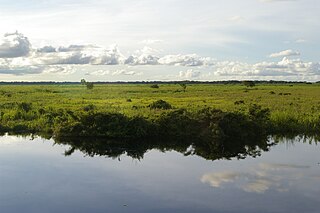
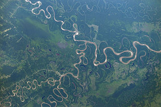
Santa Ana del Yacuma is a town in the Beni Department in north-eastern Bolivia.
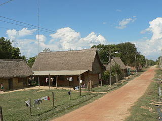
Santa Rosa de Yacuma or Santa Rosa del Yacuma is a small town in the Amazon pampas of the Bolivian Beni Department.
Campinas do Sul is a municipality in the state of Rio Grande do Sul, Brazil.
Coronel Bicaco is a municipality in the state of Rio Grande do Sul, Brazil.
This is a list of the extreme points and extreme elevations in Scotland.
Banderas River is a river located in the southern part of the Ahuachapán Department of El Salvador. Precipitations along the river are suitable for municipal water, irrigation, and water wells.
Santa Ana Municipality or Santa Ana del Yacuma Municipality is a municipality of the Beni Department, Bolivia.
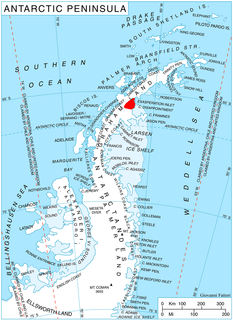
Ambergris Glacier is a glacier flowing south-southeast from Mount Sara Teodora between Chintulov Ridge and Valkosel Ridge to join Flask Glacier just west of Fluke Ridge in Aristotle Mountains on the east coast of Graham Land, Antarctica. One of several names in the area that reflect a whaling theme, it was named in 1987 by the United Kingdom Antarctic Place-Names Committee from the substance secreted by the sperm whale and used in perfumery.
Quequén is a beach town in Necochea Partido, Buenos Aires province, Argentina, on the Atlantic coast by the Quequén Grande River. With a population of 14,524 inhabitants it is one of the most important grain exporting harbours in Argentina.
Quequén, originated from the “querandí” word Kem Ken, meaning high gullies, in the language spoken by the native people.