Rørstad | |
|---|---|
Village | |
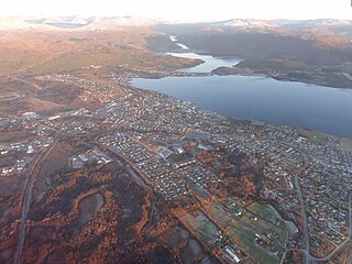
 View of the village | |
 Rørstad Location in Nordland  Rørstad Rørstad (Norway) | |
| Coordinates: 67°35′22″N15°13′28″E / 67.5894°N 15.2244°E Coordinates: 67°35′22″N15°13′28″E / 67.5894°N 15.2244°E | |
| Country | Norway |
| Region | Northern Norway |
| County | Nordland |
| District | Salten |
| Municipality | Sørfold |
| Elevation | 7 m (23 ft) |
| Time zone | UTC+01:00 (CET) |
| • Summer (DST) | UTC+02:00 (CEST) |
| Post Code | 8220 Røsvik |
Rørstad is a village in the municipality of Sørfold in Nordland county, Norway. The village is located along the Sørfolda fjord, about 25 kilometres (16 mi) south of the village of Nordfold and about 15 kilometres (9.3 mi) northwest of the village of Røsvika. The historic Rørstad Church is located in the village, and worship services are held there twice each summer.

Sørfold is a municipality in Nordland county, Norway. It is part of the traditional district of Salten. The administrative centre of the municipality is the village of Straumen. Other villages in the municipality include Leirfjordgården, Mørsvikbotn, Røsvika, Rørstad, Styrkesvik, and Øvre Kvarv. The municipality surrounds the Sørfolda fjord and stretches east to the border with Sweden.

Nordland is a county in Norway in the Northern Norway region, bordering Troms in the north, Trøndelag in the south, Norrbotten County in Sweden to the east, Västerbotten County to the southeast, and the Atlantic Ocean to the west. The county was formerly known as Nordlandene amt. The county administration is in Bodø. The remote Arctic island of Jan Mayen has been administered from Nordland since 1995.

Norway, officially the Kingdom of Norway, is a Nordic country in Northwestern Europe whose territory comprises the western and northernmost portion of the Scandinavian Peninsula; the remote island of Jan Mayen and the archipelago of Svalbard are also part of the Kingdom of Norway. The Antarctic Peter I Island and the sub-Antarctic Bouvet Island are dependent territories and thus not considered part of the kingdom. Norway also lays claim to a section of Antarctica known as Queen Maud Land.
The village area was located on a peninsula lying between the Nordfolda and Sørfolda fjords, just east of the uninhabited island, Prestmåsøya. The site was an important historical location due to the importance of boat transportation. Since boat transportation gave way to automobile transportation in the 20th century, the village became more remote. There are no road connections to Rørstad, but there are ferry connections from Røsvika in the summer. The permanent residents left the village in the late-1970s, but since then the area has been used for summer Holiday cottages. [2]

Sørfolda is a fjord in Nordland county, Norway. It is located in the municipalities of Sørfold and Bodø. The 40-kilometre (25 mi) Sørfolda is a southeastern branch of the main Folda fjord. Side branches include the Nevelsfjorden, Eidekjosen, Skjunkfjorden, and Leirfjorden. The deepest part of the fjord reaches 573 metres (1,880 ft) below sea level.

Prestmåsøya is an uninhabited island in Sørfold Municipality in Nordland county, Norway. The 4.21-square-kilometre (1.63 sq mi) island lies at the eastern end of the Folda fjord where it splits into the Nordfolda and Sørfolda. The now-abandoned village of Rørstad lies on the mainland, about 1.5 kilometres (0.93 mi) to the southeast. The island is basically one large rocky, mountain reaching 255 metres (837 ft) above sea level.

A ferry is a merchant vessel used to carry passengers, and sometimes vehicles and cargo, across a body of water. A passenger ferry with many stops, such as in Venice, Italy, is sometimes called a water bus or water taxi.