S'illot (Mallorca)

Last updated • 5 min readFrom Wikipedia, The Free Encyclopedia
S'illot
Town
Sillot02.jpg
View of the bay of S'illot and Sa Coma
Etymology: Catalan for "islet"
Location map Majorca.png
Red pog.svg
S'illot
S'illot is located in Mallorca
Coordinates: 39°34′37″N3°22′19″E / 39.577°N 3.372°E / 39.577; 3.372
CountrySpain
Autonomous Community Balearic Islands
Island Mallorca
Population
 (2016)
  Total1,988 [1]

S'illot is a small tourist town on the south east coast of the Balearic Island of Mallorca, Spain, divided between the council areas of Manacor and Sant Llorenç des Cardassar. The two districts are separated by the river Torrent de Ca n'Amer [2] which is spanned by a large bridge in the town. A range of seaside leisure activities take place in the town. At the entrance to the town there is prehistoric settlement that is well preserved. [3]

Contents

Geography

S'Illot is located 63 km east of Palma de Mallorca and 16 km east of Manacor. The little cove of Cala Morlanda and the wide beach of Cala Moreia are situated to the town's south, while the resort of Sa Coma lies immediately to its north. [3] There is a headland of craggy rock projecting out into the sea between S'illot and Sa Coma. [4]

S'Illot is near the larger town of Porto Cristo and other tourist resorts such as Cala Millor. [5] It is linked to Palma and to Palma de Mallorca Airport by the Autovia MA-15 highway that crosses the island from east to west. [6] [7]

History

The word "Illot" is Catalan for "islet", and the name is derived from a small rocky island off the coast. [3] The site of the town was occupied in prehistory, but was abandoned around the second century BC at the time of the Romanisation of Mallorca following the Second Punic War. [2]

Modern S'illot developed from a fishing village and fishing boats still work from a small harbour. [6] [7] The town originated as summer resort for the inhabitants of Manacor in the 1930s. The division of Ca n'Amer de S'Illot into development plots was approved in 1948 and the urban development of S'Illot took place from 1959. In 1965 S'Illot and Cala Millor together had 19 hotels with a total of 1414 beds. [3] Tourism is now the town's primary economic activity. [5]

Facilities

Map showing the location of S'illot Mapa play manacor2.png
Map showing the location of S'illot

The town is mostly flat. [5] Its beach is 350 metres long with an average width of 50 metres. [6] It is a sandy Blue Flag beach and is backed by a promenade [8] with bars, restaurants, cafes and tourist shops. [7] Beach-related facilities include lifeguards, showers and the rental of sun loungers, parasols and watersports equipment. [6]

The town has many hotels [5] but is quieter than the neighbouring resort of Sa Coma with few lively bars, the evening entertainment being mainly provided by the hotels. [7] There is also a small Eroski supermarket called "aprop" [9] and a tourist information office. [10] S'illot is on a number of bus routes. [5]

Population

It is difficult to measure the population of this tourist town due to its membership of two different municipalities. According to data from 2016, 243 inhabitants lived in the Sant Llorenç part and 1745 in the Manacor part. However, the latter figure also includes residents of the small resort of Cala Morlanda. [1] As many of the dwellings are second homes, the population increases notably the summer months. [3]

Ancient monument

Central part of the Talaiotic village settlement of s'Illot Poblat Talaiotic de S'Illot 39.JPG
Central part of the Talaiotic village settlement of s'Illot

Within the current town there are the remains of the Poblat Talaiòtic de s'Illot, a Talaiotic village. The earliest discoveries on the site date from 2200 BC [2] and the talliot itself dates from around 1100 BC. The site reflects the Talaiotic culture of the Balearic islands between the late 2nd millennium BCE and the Punic Wars in the late 1st millennium BCE. [11] The approximately 200 inhabitants of the settlement mainly practiced agriculture. Of great importance were hunting and the breeding of pigs and sheep. At the village's centre was a square talaiot (a megalithic structure of uncertain purpose) surrounded by 35 houses, which in turn were surrounded by the defensive wall of the town. In 123 BC the settlement was abandoned as a result of Roman colonization of the island. Between 1960 and 1970 the settlement was excavated by archaeologists from the University of Marburg. The remains are now located in a public square set amongst housing and hotels. The site is open to the public following a redevelopment project which has added walkways and picnic areas, [12] viewing platforms and interpretation boards, and a visitor centre. [2]

Nearby places of Interest

Annual celebrations and events

Related Research Articles

<span class="mw-page-title-main">Mallorca</span> Island in the Mediterranean Sea

Mallorca, or Majorca, is the largest island of the Balearic Islands, which are part of Spain, and the seventh largest island in the Mediterranean Sea.

<span class="mw-page-title-main">Manacor</span> Municipality in Balearic Islands, Spain

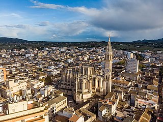
Manacor is a town and municipality on the island of Mallorca, part of the Spanish autonomous community of the Balearic Islands. It is the second largest town in Mallorca, after the capital of Palma. The municipality has tourist areas such as Porto Cristo, site of the famous Caves of Drach, and Cales de Mallorca. Manacor has one of the busiest street markets on the island, held every Monday morning. Manacor is famous for high-quality wood furniture manufacture and artificial pearls.

<span class="mw-page-title-main">Alcúdia</span> Municipality in Balearic Islands, Spain

Alcúdia (Catalan pronunciation:[əlˈkuði ]) is a municipality and township of the Spanish autonomous community of the Balearic Islands. It is the main tourist centre in the North of Majorca on the eastern coast. It is a large resort popular with tourists. Most of the hotels are located in Port d'Alcúdia and Platja d'Alcúdia, along the 14 km-long (8.7 mi) beach that stretches all the way to Ca'n Picafort. In Alcúdia, the old town is well preserved with houses dating back to the 13th century. The old town is surrounded by a medieval wall.

<span class="mw-page-title-main">Llucmajor</span> Municipality in Balearic Islands, Spain

Llucmajor is the largest municipality of the Balearic Island of Mallorca.

<span class="mw-page-title-main">Magaluf</span> Place in Balearic Islands, Spain

Magaluf is a major holiday resort on the Spanish island of Majorca, primarily catering to the British, Russian, Irish, German, and Scandinavian package holiday market. Magaluf is in the municipality of Calvià and is situated within a group of towns, primarily Torrenova and Palma Nova. Son Sant Joan Airport – Majorca's main airport – is 24 kilometres (15 mi) from Magaluf.

<span class="mw-page-title-main">Andratx</span> Municipality in Balearic Islands, Spain

Andratx is a municipality on Mallorca, one of the Balearic Islands, along the Mediterranean east coast of Spain. It is located on the southwest tip of the island.

<span class="mw-page-title-main">Artà</span> Municipality and town in Balearic Islands, Spain

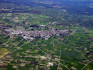
Artà is one of the 53 independent municipalities on the Spanish Balearic island of Majorca. The small town of the same name is the administrative seat of this municipality in the region (Comarca) of Llevant.

<span class="mw-page-title-main">Santa Margalida</span> Municipality in Balearic Islands, Spain

Santa Margalida is a municipality with a population of 10,204 located in the northeast of the Spanish Balearic Island Majorca.

<span class="mw-page-title-main">Sant Llorenç des Cardassar</span> Municipality in Balearic Islands, Spain

Sant Llorenç des Cardassar is a small municipality on Mallorca, one of the Balearic Islands, Spain.

<span class="mw-page-title-main">Cala d'Or</span> Place in Balearic Islands, Spain

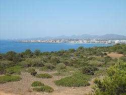
Cala d'Or is a village on the east coast of the island of Mallorca, in the municipality of Santanyí, Balearic Islands, Spain.

<span class="mw-page-title-main">Dragonera</span> Island in Balearic Islands, Spain

Sa Dragonera is an uninhabited islet in the Balearic Islands, Spain, located just off the west coast of Majorca. It is currently a natural park.

<span class="mw-page-title-main">Sa Coma</span> Resort town in Majorca, Spain

Sa Coma is a town on the east coast of the island of Majorca, Spain. It is close to the towns of Cala Millor and Cala Bona in the municipality of Sant Llorenç des Cardassar. To the south it merges with the small town of S'illot.

<span class="mw-page-title-main">Cala Millor</span> Town on Balearic Island, Spain

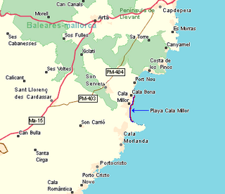
Cala Millor is a town located on the Spanish Balearic Island of Mallorca. It consists of a small bay in the municipalities of Son Servera and Sant Llorenç des Cardassar. Overlooked by Mt. Na Penyal to the west.

<span class="mw-page-title-main">Cala de Sant Vicent</span> Beach Resort Village in Balearic Islands, Spain

Cala de Sant Vicent is a beach resort village on the Spanish island of Ibiza. The resort is in the municipality of Sant Joan de Labritja. The resort is reached along the designated roads PMV 811 east from Sant Joan de Labritja, and on the PM 810 north from Santa Eulària des Riu. The resort is 18.9 miles (30.4 km) north east of Ibiza Town and 23.5 miles (37.8 km) of Ibiza Airport. The resort is 3.0 kilometres (1.9 mi) along a valley, east of the small community of Sant Vicent de sa Cala.

Porto Cristo is a small town on the eastern coast of Mallorca. It is 14 km (9 mi) from the town of Manacor and is within the Manacor municipality.

The Majorca rail network consists of three separate electrified lines, which radiate north and east from Palma de Mallorca, the major city on the Spanish island of Majorca.

A Natural Area of Special Interest is a protected area within the Balearic Islands, Spain that is below the level of a natural park.

<span class="mw-page-title-main">Talaiotic culture</span>

The Talaiotic Culture or Talaiotic Period is the name used to describe the society that existed on the Gymnesian Islands during the Iron Age. Its origins date from the end of the second millennium BC, when the inaccurately named Pre-Talaiotic Culture underwent a crisis and evolved into the Talaiotic Culture. Its name is derived from the talaiots, which are the most abundant and emblematic structures from the prehistoric period of the Balearic Islands.

<span class="mw-page-title-main">Cala Bona</span> Town in Majorca, Spain

Cala Bona is a small fishing town and holiday resort on the east coast of Majorca in the Balearic Islands of Spain. It consists of a cove with a harbour and surrounding coastal area and lies within the municipality of Son Servera. The population of the town in 2005 was 1,088 inhabitants. In 2011, it had a population of 1,258. It is located to the north of Cala Millor, to which is connected by a promenade, and it lies to the south of Port Verd. Fodor's 1989 guide to Spain described Cala Bona in these terms: "Once an unspoiled fishing village, but now overwhelmed by neighboring Cala Millor. Mixed rocky and excellent sandy beach."

<span class="mw-page-title-main">Cala Morell Settlement</span>

The settlement of Cala Morell is a Menorcan pre-talayotic archaeological site which is located in Ciutadella de Menorca. It is situated on a 35-meter-high coastal headland which closes the northeast side of Cala Morell's bay. This promontory is protected by a dry-stone wall, which is found in the area where the promontory connects to solid ground. It shares many features with another site which is located some kilometers away from it: Es Castellet des Pop Mosquer.

References

  1. 1 2 "List of place name: Population of the Continuous Municipal Register by Population Unit at 1st January 2016". Instituto Nacional de Estadística. Retrieved 26 July 2017.
  2. 1 2 3 4 5 "S'Illot". Visit Cala Millor. Retrieved 6 September 2017.
  3. 1 2 3 4 5 6 "s'Illot". Visit Manacor. Retrieved 26 July 2017.
  4. "S'Illot". Palma Airport Info. Retrieved 13 July 2018.
  5. 1 2 3 4 5 "S'Illot". VisitMajorca.net.
  6. 1 2 3 4 "S'Illot - Cala Moreia beach". Mallorca Beaches. Retrieved 10 July 2018.
  7. 1 2 3 4 5 "Relax and unwind in one of Majorca's most chilled beach resorts". Majorca Guides. Retrieved 25 May 2018.
  8. 1 2 "S'Illot, Mallorca - Map and Information". Mallorca Maps. Archived from the original on 3 November 2009. Retrieved 25 May 2018.
  9. "APROP S'ILLOT: Horario, Dirección y Télefono". Eroski.
  10. "S'Illot Tourist Information Offices". majorca-mallorca.co.uk.
  11. "Benvinguts a la web del poblat talaiòtic de s'illot" [Welcome to the Website of Talaiotic S'illot] (in Catalan). Ajuntament de Sant Llorenç des Cardassar. Retrieved 4 June 2017.
  12. Sarah Dawood (9 January 2017). "What's your favourite example of design in the public sector?". Design Week.

39°34′37″N3°22′19″E / 39.577°N 3.372°E / 39.577; 3.372