Sant Llorenç des Cardassar

Last updated • 2 min readFrom Wikipedia, The Free Encyclopedia
Sant Llorenç des Cardassar
Sillot02.jpg
A view of the bay of s'Illot and Sa Coma
Escudo de San Lorenzo de Cardessar (Islas Baleares).svg
Localitzacio de Sant Llorenc des Cardassar respecte de Mallorca.svg
Location within Mallorca
Location map Majorca.png
Red pog.svg
Sant Llorenç des Cardassar
Location in Mallorca
Spain Balearic Islands location map.svg
Red pog.svg
Sant Llorenç des Cardassar
Sant Llorenç des Cardassar (Balearic Islands)
Spain location map with provinces.svg
Red pog.svg
Sant Llorenç des Cardassar
Sant Llorenç des Cardassar (Spain)
Coordinates: 39°36′35″N3°17′02″E / 39.60972°N 3.28389°E / 39.60972; 3.28389
CountryFlag of Spain.svg  Spain
Autonomous community Flag of the Balearic Islands.svg  Balearic Islands
Province Balearic Islands
Comarca Llevant
Judicial district Manacor
Government
  MayorMateo Puigrós Sureda
Area
  Total82.08 km2 (31.69 sq mi)
Elevation
89 m (292 ft)
Population
 (2018) [1]
  Total8,405
  Density100/km2 (270/sq mi)
Time zone UTC+1 (CET)
  Summer (DST) UTC+2 (CEST)
Postal code
07530

Sant Llorenç des Cardassar (Catalan pronunciation: [ˈsandʎuˈɾɛnzðəskəɾðəˈsa] ) is a small municipality on Mallorca, one of the Balearic Islands, Spain.

Contents

History

The Punta de n'Amer Castle  [ ca ] was built in the 17th century. [2] Sant Llorenç des Cardassar was part of the municipality of Manacor, until 1892. [2]

Sant Llorenç des Cardassar was the tragic scene of flash floods on the night of 9 October 2018, in which 13 people died. Some 400 troops of the Spanish Army, Civil Guard, firemen, local police, and Civil Protection were mobilized to help trapped people and locate those missing. More than 200 people slept in shelters that were set up for those affected. [3]

Geography

Sant Llorenç is 34 mi (55 km) east of Palma de Mallorca, [4] the island's capital. The municipality, on the eastern coast of the island of Mallorca, adjoins the municipalities of Manacor, Petra, Artà and Son Servera. Inland, the municipality contains the town centre of Sant Llorenç and the village of Son Carrió  [ es ]. On the coast, within the municipality, are Sa Coma, the northern part of s'Illot, and the southern part of Cala Millor, which are all beachside tourist areas. The Punta de n'Amer  [ ca ], a headland at the eastern end of the municipality, separates the beaches of Cala Millor and Sa Coma.

Demography

Historical population
YearPop.±%
1897 2,503    
1900 2,464−1.6%
1910 2,920+18.5%
1920 3,065+5.0%
1930 3,706+20.9%
YearPop.±%
1940 3,745+1.1%
1950 3,869+3.3%
1960 3,622−6.4%
1970 3,924+8.3%
1981 3,955+0.8%
YearPop.±%
1991 4,416+11.7%
2001 6,503+47.3%
2011 8,490+30.6%
Note: De jure population
Source: [5]

Transport

Roads

The Ma-15  [ es ], the main road from Palma, acts as a bypass around the southern and eastern sides of the town centre of Sant Llorenç, continuing north through Artà. The Ma-4030 road connects the town centre of Sant Llorenç with Son Servera, to the east. The Ma-4023 road is on an approximate north-south axis, parallel to the coast but about 1 mi (1.6 km) inland from the beach areas, connecting Son Servera with Porto Cristo.

Media

The ITV2 series Love Island is filmed on the outskirts of the town. [6] [7]

Notable people

Related Research Articles

<span class="mw-page-title-main">Mallorca</span> Island in the Mediterranean Sea

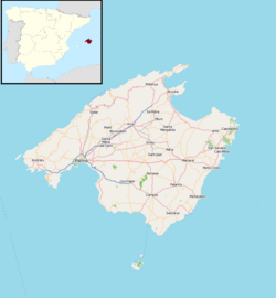
Mallorca, or Majorca, is the largest island of the Balearic Islands, which are part of Spain, and the seventh largest island in the Mediterranean Sea.

<span class="mw-page-title-main">Manacor</span> Municipality in Balearic Islands, Spain

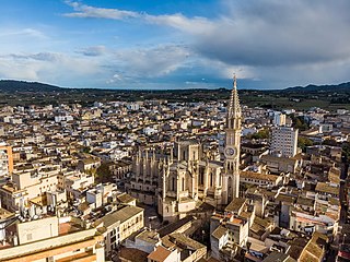
Manacor is a town and municipality on the island of Mallorca, part of the Spanish autonomous community of the Balearic Islands. It is the second largest town in Mallorca, after the capital of Palma. The municipality has tourist areas such as Porto Cristo, site of the famous Caves of Drach, and Cales de Mallorca. Manacor has one of the busiest street markets on the island, held every Monday morning. Manacor is famous for high-quality wood furniture manufacture and artificial pearls.

<span class="mw-page-title-main">Llucmajor</span> Municipality in Balearic Islands, Spain

Llucmajor is the largest municipality of the Balearic Island of Mallorca.

<span class="mw-page-title-main">Magaluf</span> Place in Balearic Islands, Spain

Magaluf is a major holiday resort on the Spanish island of Majorca, primarily catering to the British, Russian, Irish, German, and Scandinavian package holiday market. Magaluf is in the municipality of Calvià and is situated within a group of towns, primarily Torrenova and Palma Nova. Son Sant Joan Airport – Majorca's main airport – is 24 kilometres (15 mi) from Magaluf.

<span class="mw-page-title-main">Andratx</span> Municipality in Balearic Islands, Spain

Andratx is a municipality on Mallorca, one of the Balearic Islands, along the Mediterranean east coast of Spain. It is located on the southwest tip of the island.

<span class="mw-page-title-main">Artà</span> Municipality and town in Balearic Islands, Spain

Artà is one of the 53 independent municipalities on the Spanish Balearic island of Majorca. The small town of the same name is the administrative seat of this municipality in the region (Comarca) of Llevant.

<span class="mw-page-title-main">Santa Margalida</span> Municipality in Balearic Islands, Spain

Santa Margalida is a municipality with a population of 10,204 located in the northeast of the Spanish Balearic Island Majorca.

<span class="mw-page-title-main">Son Servera</span> Municipality in Balearic Islands, Spain

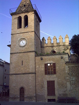
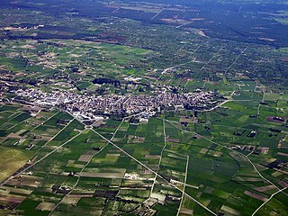
Son Servera is a municipality in northeast Majorca, in the Balearic Islands, Spain.

<span class="mw-page-title-main">Sant Lluís</span> Municipality in Balearic Islands, Spain

Sant Lluís is a municipality on the tip of south-east Menorca in the Spanish Balearic Islands.

<span class="mw-page-title-main">Sa Coma</span> Resort town in Majorca, Spain

Sa Coma is a town on the east coast of the island of Majorca, Spain. It is close to the towns of Cala Millor and Cala Bona in the municipality of Sant Llorenç des Cardassar. To the south it merges with the small town of S'illot.

<span class="mw-page-title-main">Cala Millor</span> Town on Balearic Island, Spain

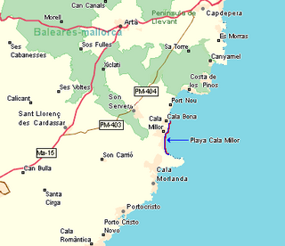
Cala Millor is a town located on the Spanish Balearic Island of Mallorca. It consists of a small bay in the municipalities of Son Servera and Sant Llorenç des Cardassar. Overlooked by Mt. Na Penyal to the west.

<span class="mw-page-title-main">Xeremia</span> Bagpipe from Majorca

The xeremia is a type of bagpipe native to the island of Majorca (Mallorca). It consists of a bag made of skin, known as a sac or sarró which retains the air, a blowpipe (bufador), a melody pipe or chanter (grall), and several, generally three, drones (bordons). The primary drone (roncó) sounds a tonic note, but the other drones are sometimes simply false drones for ornamentation.

Porto Cristo is a small town on the eastern coast of Mallorca. It is 14 km (9 mi) from the town of Manacor and is within the Manacor municipality.

The Majorca rail network consists of three separate electrified lines, which radiate north and east from Palma de Mallorca, the major city on the Spanish island of Majorca.

The Divisiones Regionales de Fútbol in the Balearic Islands, are organized by Balearic Football Federation :

<span class="mw-page-title-main">S'illot (Mallorca)</span> Town in Balearic Islands, Spain

S'illot is a small tourist town on the south east coast of the Balearic Island of Mallorca, Spain, divided between the council areas of Manacor and Sant Llorenç des Cardassar. The two districts are separated by the river Torrent de Ca n'Amer which is spanned by a large bridge in the town. A range of seaside leisure activities take place in the town. At the entrance to the town there is prehistoric settlement that is well preserved.

A Natural Area of Special Interest is a protected area within the Balearic Islands, Spain that is below the level of a natural park.

<span class="mw-page-title-main">Cala Bona</span> Town in Majorca, Spain

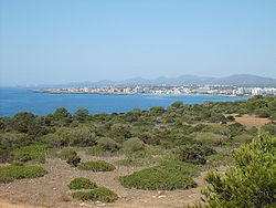
Cala Bona is a small fishing town and holiday resort on the east coast of Majorca in the Balearic Islands of Spain. It consists of a cove with a harbour and surrounding coastal area and lies within the municipality of Son Servera. The population of the town in 2005 was 1,088 inhabitants. In 2011, it had a population of 1,258. It is located to the north of Cala Millor, to which is connected by a promenade, and it lies to the south of Port Verd. Fodor's 1989 guide to Spain described Cala Bona in these terms: "Once an unspoiled fishing village, but now overwhelmed by neighboring Cala Millor. Mixed rocky and excellent sandy beach."

<span class="mw-page-title-main">Llevant</span>

Llevant is a comarca on the east side of the Balearic island of Majorca.

References

  1. Municipal Register of Spain 2018. National Statistics Institute.
  2. 1 2 "The town of Sant Llorenç des Cardassar in Majorca". ViaGallica. Retrieved 1 August 2018.
  3. "Deadly flash flooding hits Majorca". BBC News. 10 October 2018. Retrieved 11 October 2018.
  4. "Coordinate Distance Calculator". Boulter.com. Retrieved 31 July 2018.
  5. "Municipio: 07051 Sant Llorenç des Cardassar" [Municipality: 07051 Sant Llorenç des Cardassar]. Instituto Nacional de Estadística (in Spanish). Retrieved 1 August 2018.
  6. "Love Island: Where was Jack from? And other questions answered". BBC News. 31 July 2018. Retrieved 31 July 2018.
  7. Conroy, Jade; Johnstone, Charlotte (24 July 2017). "Love Island 2017 filming locations revealed". The Telegraph. Retrieved 31 July 2018.