Mallorca, or Majorca, is the largest island of the Balearic Islands, which are part of Spain, and the seventh largest island in the Mediterranean Sea.
Ibiza is a Spanish island in the Mediterranean Sea off the eastern coast of the Iberian Peninsula. It is 150 kilometres from the city of Valencia. It is the third largest of the Balearic Islands in area, but the second-largest by population. Its largest settlements are Ibiza Town, Santa Eulària des Riu, and Sant Antoni de Portmany. Its highest point, called Sa Talaiassa, is 475 metres above sea level.

Palma, also known as Palma de Mallorca, is the capital and largest city of the autonomous community of the Balearic Islands in Spain. It is situated on the south coast of Mallorca on the Bay of Palma. The Cabrera Archipelago, though widely separated from Palma proper, is administratively considered part of the municipality.

Pollença is a town and municipality in the northern part of the island of Majorca, near Cap de Formentor and Alcúdia. It lies inland, about 6 km (4 mi) west of its port, Port de Pollença.

Llucmajor is the largest municipality of the Balearic Island of Mallorca.

Banyalbufar is a municipality on the Spanish Balearic island of Majorca. The town of the same name is the administrative seat of the municipality. It borders the municipalities of Estellencs, Puigpunyent, Esporles, and Valldemossa.

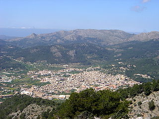
Bunyola is a municipality of the island of Mallorca, Spain, located in the spurs of the Serra de Tramuntana, at a distance of 9 miles (14 km) from Palma. The municipality has an area of 32.67 square miles (84.6 km2) and a population of 6,636 inhabitants,INE Instituto Nacional Estadística and the Ferrocarril de Sóller passes through it on the way to Palma..

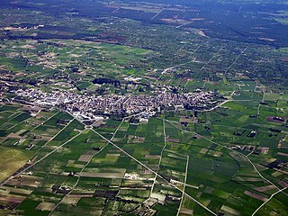
Marratxí is a municipality in the Raiguer region of Majorca, one of the Balearic Islands of Spain. As of 2005, it has a population of 28,237 and an area of 54 km2. It is also a station on the Majorca rail network. It became a municipality on 9 November 1932.
Andratx is a municipality on Mallorca, one of the Balearic Islands, along the Mediterranean east coast of Spain. It is located on the southwest tip of the island.

Artà is one of the 53 independent municipalities on the Spanish Balearic island of Majorca. The small town of the same name is the administrative seat of this municipality in the region (Comarca) of Llevant.
Santa Margalida is a municipality with a population of 10,204 located in the northeast of the Spanish Balearic Island Majorca.

Sant Llorenç des Cardassar is a small municipality on Mallorca, one of the Balearic Islands, Spain.

The Serra de Tramuntana is a mountain range running southwest–northeast which forms the northern backbone of the Spanish island of Mallorca. It is also the name given to the comarca of the same area. On 27 June 2011, the Tramuntana Range was awarded World Heritage Status by UNESCO as an area of great physical and cultural significance.

Sa Dragonera is an uninhabited islet in the Balearic Islands, Spain, located just off the west coast of Majorca. It is currently a natural park.
The Majorca rail network consists of three separate electrified lines, which radiate north and east from Palma de Mallorca, the major city on the Spanish island of Majorca.

The Balearic Islands are an archipelago in the western Mediterranean Sea, near the eastern coast of the Iberian Peninsula. The archipelago conforms a province and autonomous community of Spain, with Palma de Mallorca being its capital and largest city.
S'illot is a small tourist town on the south east coast of the Balearic Island of Mallorca, Spain, divided between the council areas of Manacor and Sant Llorenç des Cardassar. The two districts are separated by the river Torrent de Ca n'Amer which is spanned by a large bridge in the town. A range of seaside leisure activities take place in the town. At the entrance to the town there is prehistoric settlement that is well preserved.

Son Ferrer is a new village in the municipality of Calvià on the island of Majorca, part of the Spanish autonomous community of the Balearic Islands. Son Ferrer is located about 20 km (12 mi) from the capital, Palma de Mallorca. Its neighbors include La Porrassa to the east, El Toro to the west, Santa Ponsa to the northwest, and the forested area of Cala Figuera. Son Ferrer is surrounded by forests of pine and is adjacent to farms. It is divided into two zones, a commercial area and a residential area. The census in 2008 was 5666 inhabitants.

The conquest of the island of Majorca on behalf of the Roman Catholic kingdoms was carried out by King James I of Aragon between 1229 and 1231. The pact to carry out the invasion, concluded between James I and the ecclesiastical and secular leaders, was ratified in Tarragona on 28 August 1229. It was open and promised conditions of parity for all who wished to participate.

The Battle of Portopí was an open field military conflict between the Almohad troops that occupied the island of Majorca and the Christian army led by King James I the Conqueror with the aim of annexing it to the Crown of Aragon in order to expand their domain. It was carried out at various points in the current Sierra de Na Burguesa, approximately halfway between the current resort town of Santa Ponsa and the City of Majorca. It was the second major battle in the campaign for the conquest of the island of Majorca initiated by the Aragonese king.