| City route 116 | |
|---|---|
| Stadsroute 116 | |
 | |
| Major junctions | |
| North end | |
| South end | |
| Location | |
| Provinces | North Holland |
| Municipalities | Amsterdam |
| Highway system | |
S116 is a Dutch road in Amsterdam.
| City route 116 | |
|---|---|
| Stadsroute 116 | |
 | |
| Major junctions | |
| North end | |
| South end | |
| Location | |
| Provinces | North Holland |
| Municipalities | Amsterdam |
| Highway system | |
S116 is a Dutch road in Amsterdam.

The Virgin Islands are an archipelago in the Caribbean Sea. They are geologically and biogeographically the easternmost part of the Greater Antilles, the northern islands belonging to the Puerto Rico Trench and St. Croix being a displaced part of the same geologic structure. Politically, the British Virgin Islands have been governed as the western island group of the Leeward Islands, which are the northern part of the Lesser Antilles, and form the border between the Caribbean Sea and the Atlantic Ocean. The archipelago is separated from the true Lesser Antilles by the Anegada Passage and from the main island of Puerto Rico by the Virgin Passage.

Numbered highways in Canada are split by province, and a majority are maintained by their province or territory transportation department. All highways in Canada are numbered except for three in the Northwest Territories, one in Alberta, one in Ontario, and one in Quebec. Ontario's 7000 series are not marked with their highway number but have been assigned one by the Ministry of Transportation. A number of highways in all provinces are better known locally by their name rather than their number. Some highways have additional letters added to their number: A is typically an alternate route, B is typically a business route, and other letters are used for bypass (truck) routes, connector routes, scenic routes, and spur routes. The territory of Nunavut has no highways.

The Golden Quadrilateral is a national highway network connecting most of the major industrial, agricultural and cultural centres of India. It forms a quadrilateral connecting the four major metro cities of India, viz., Delhi (north), Kolkata (east), Mumbai (west) and Chennai (south). Other cities connected by this network include Ahmedabad, Bengaluru, Balasore, Bhubaneswar, Cuttack, Berhampur, Durgapur, Jaipur, Kanpur, Pune, Kolhapur, Surat, Vijayawada, Ajmer, Vizag, Bodhgaya, Varanasi, Allahabad, Agra, Mathura, Dhanbad, Gandhinagar, Udaipur, and Vadodara. The main objective of these super highways is to reduce the distance and time between the four mega cities of India. The North-South corridor linking Srinagar(Jammu and Kashmir) and Kanyakumari ,and East-West corridor linking Silchar(Assam) and Porbandar (Gujarat) are part of this project.These highway projects are implemented by the National Highway Authority Of India(NHAI). At 5,846 kilometres (3,633 mi), it is the largest highway project in India and the fifth longest in the world. It is the first phase of the National Highways Development Project (NHDP), and consists of four and six-lane express highways, built at a cost of ₹600 billion (US$8.0 billion). The project was planned in 1999, launched in 2001, and was completed in 2013.

A roadgeek is an individual involved in "roadgeeking" or "road enthusiasm"—an interest in roads, and especially going on road trips, as a hobby. A person with such an interest is also referred to as a road enthusiast, road buff, roadfan or Roads Scholar, the latter being a play on the term Rhodes Scholar.

The North–South–East–West Corridor (NS-EW) is the largest ongoing highway project in India. It is the second phase of the National Highways Development Project (NHDP), and consists of building 7300 kilometers of four/six lane expressways associating Srinagar, Kanyakumari, Kochi, Porbandar and Silchar, at a cost of US$12.317 billion. As of 31 March 2018, 6875 of the 7142 kilometers project has been finished.
The Victoria Bridge is a heritage-listed timber trestle truss road bridge across the Stonequarry Creek, located at Prince Street in the south-western Sydney town of Picton in the Wollondilly Shire local government area of New South Wales, Australia. The bridge is owned by Transport for NSW, an agency of the Government of New South Wales. The bridge is also known as the Victoria Bridge over Stonequarry Creek. It was added to the New South Wales State Heritage Register on 20 June 2000. Designed by Percy Allan and opened on 7 October 1897, Victoria Bridge employs Allan trusses and was built by C. J. Ford of Sydney.
There are many classes of roads in Ontario, Canada, including provincial highways, county roads, and local municipal routes.
The A38 is a major trunk road running from the south-east of Bodmin in Cornwall to Mansfield in Nottinghamshire. At 292 miles (470 km), it is the longest 'A' road entirely within England.

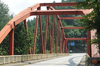
National Route 120 is a national highway of Japan connecting Nikkō, Tochigi and Numata, Gunma in Japan, with a total length of 95.2 km (59.15 mi). A section of the highway is designated as a part of the Japan Romantic Road.

National Route 122 is a national highway of Japan connecting Nikkō, Tochigi and Toshima, Tokyo in Japan, with a total length of 158.3 km (98.36 mi).

National Route 140 is a national highway of Japan connecting Kumagaya, Saitama and Fujikawa, Yamanashi in Japan, with a total length of 146.6 km (91.1 mi).

National Route 257 is a national highway of Japan connecting Nishi-ku, Hamamatsu and Takayama, Gifu in Japan, with a total length of 241.6 km (150.1 mi).

G.B. Road,Garstin Bastion Road, is a road running from Ajmeri Gate to Lahori Gate in Delhi, India. It is a large red-light district. It has several hundred multi-storey brothels and there are estimated to be over 1000 sex workers. It is lined with two or three-storey buildings that have shops on ground floor. About twenty of these buildings have about 100 brothels on the first floor that open at night after the shops at ground level close. It is the biggest red light area in Delhi.

Expressways are the highest class of roads in India. As of January 2022, India has a total of 2,074.5 km expressways. These are controlled-access highways where entrance and exits are controlled by the use of ramps that are incorporated into the design of the expressway, whereas National highways are at-grade roads. Some roads are not access-controlled expressway, but are still officially called expressways, such as the Biju Expressway, Ranchi Hazaribagh Expressway and Raipur–Bilaspur Expressway. Currently, the longest expressway in India is the Purvanchal Expressway at 340.8 km and the widest expressway is the Delhi–Meerut Expressway at 14 lanes.

The R918 road is a regional road in Ireland which connects J6 of the N11 to the R761 at Little Bray. The majority of the known as the Dargle Road and the Upper Dargle Road.
The River Lett, a perennial stream of the Hawkesbury-Nepean catchment, is located in the Central Tablelands region of New South Wales, Australia.

National Highway 183A, also known as NH 183A, is a National Highway in the Indian state of Kerala that runs from Chavara Titanium JunctionKollam, to Vandiperiyar via Adoor and Pathanamthitta. It is the 4th National Highway passing through the Kollam district.

The Stockton Bridge is a road bridge that carries the Nelson Bay Road (B83) across the Hunter River, between Kooragang and Stockton in the Hunter Region of New South Wales, Australia. The bridge and Nelson Bay Road serve as the main transport route between Newcastle and the Tilligerry and Tomaree peninsulas in Port Stephens. The bridge carries motor vehicles and a central grade-separated shared cycleway and footpath.