Related Research Articles

Victoria is the capital city of the Canadian province of British Columbia, on the southern tip of Vancouver Island off Canada's Pacific coast. The city has a population of 91,867, and the Greater Victoria area has a population of 397,237. The city of Victoria is the seventh most densely populated city in Canada with 4,406 inhabitants per square kilometre (11,410/sq mi).

Saanich—Gulf Islands is a federal electoral district in British Columbia, Canada, that has been represented in the House of Commons of Canada since 1988. It is named for its geographical location across the Gulf Islands and Saanich Peninsula in the Vancouver Island region.

Saanich North and the Islands is a provincial electoral district for the Legislative Assembly of British Columbia, Canada. It is located in the northern suburbs of the provincial capital, Victoria, and includes the southern Gulf Islands.

The Galloping Goose Regional Trail is a 55-kilometre (34 mi) rail trail between Victoria, British Columbia, Canada, and the ghost town of Leechtown, north of Sooke, where it meets the old Sooke Flowline. Maintained by the Capital Regional District (CRD), the trail forms part of the Trans-Canada Trail, and intersects the Lochside Regional Trail. The section from Harbour Road in Esquimalt to the Veterans Memorial Parkway in Langford is also part of the Vancouver Island Trail.
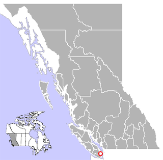
Brentwood Bay is a small village in the municipality of Central Saanich, on the Saanich Peninsula in British Columbia, Canada. It lies north of the city of Victoria, east of the community of Willis Point, and south of the town of Sidney.

Malahat is an unincorporated area in the Cowichan Valley, with municipal-type services delivered by the Cowichan Valley Regional District. What could be considered the hub of the community is a small collection of businesses that includes the Malahat Gas station and the Malahat Chalet and the Moon Water Lodge.
Saanich Peninsula is located north of Victoria, British Columbia, Canada. It is bounded by Saanich Inlet on the west, Satellite Channel on the north, the small Colburne Passage on the northeast, and Haro Strait on the east. The exact southern boundary of what is referred to as the "Saanich Peninsula" is somewhat fluid in local parlance.

Cadboro Bay is a bay near the southern tip of Vancouver Island and its adjacent neighbourhood in the municipalities of Saanich and Oak Bay in Greater Victoria, British Columbia, Canada.
The Artificial Reef Society of British Columbia (ARSBC) is a registered non-profit society based in Vancouver, British Columbia (BC), and has been a registered tax-deductible charity in Canada since 1992.

Patricia Bay is a body of salt water that extends east from Saanich Inlet and forms part of the shoreline of North Saanich, British Columbia. It lies due west of Victoria International Airport. A municipal park covers most of its eastern shore except at the southern end, which is home to a Canadian Coast Guard base, a seaplane port known as Victoria Airport Water Aerodrome, and two Canadian Government research facilities – the Institute of Ocean Sciences and GSC Pacific Sidney.

Gordon Head is a seaside neighbourhood in the municipality of Saanich in Greater Victoria, British Columbia, Canada. Gordon Head lies north of McKenzie Avenue and east of the Blenkinsop Valley. The University of Victoria is located partly within Gordon Head along the southeast boundary. Finnerty Road separates Gordon Head from the adjacent neighbourhood of Cadboro Bay. The local area is dominated physically by Mount Douglas, a coastline along Haro Strait, and the central plateau.
The Elk/Beaver Regional Park is a 1,072-acre (434 ha) park in Saanich, British Columbia, containing Elk Lake and Beaver Lake.

Victoria Harbour is a harbour, seaport, and seaplane airport in the Canadian city of Victoria, British Columbia. It serves as a cruise ship and ferry destination for tourists and visitors to the city and Vancouver Island. It is both a port of entry and an airport of entry for general aviation. Historically it was a shipbuilding and commercial fishing centre. While the Inner Harbour is fully within the City of Victoria, separating the city's downtown on its east side from the Victoria West neighbourhood, the Upper Harbour serves as the boundary between the City of Victoria and the district municipality of Esquimalt. The inner reaches are also bordered by the district of Saanich and the town of View Royal. Victoria is a federal "public harbour" as defined by Transport Canada. Several port facilities in the harbour are overseen and developed by the Greater Victoria Harbour Authority, however the harbour master's position is with Transport Canada.

SS Cyprus was a lake freighter that sank during a gale storm on Lake Superior on 11 October 1907. The ship went down in 460 feet of water at 46.79°N 85.60°W, about 8 miles north of Deer Park in Luce County, Michigan. All but one of the 23 members of the crew perished.
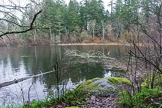
The Goldstream River is a river northwest of Victoria on southern Vancouver Island, British Columbia, Canada. The river's name derives from a small gold rush in its basin during the 1860s, and was originally Gold Stream.
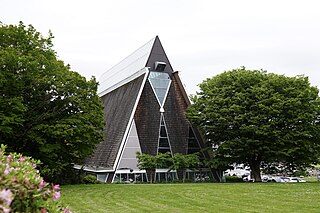
Saanich Commonwealth Place is a recreation center located west of the Patricia Bay Highway and north of Royal Oak Drive in Saanich, British Columbia in Canada. It was originally constructed in 1993 for the August 1994 Commonwealth Games, and is currently a facility in the community. In 2002 the original weightroom was completely renovated and it re-opened for operation in 2004. Among the center's other features are a full-size gymnasium, a 50-meter competition pool, 4.5 meter deep dive tank with 1-, 3-, 5-, 7.5-, and 10-meter boards, and the Bruce Hutchison Branch of the Greater Victoria Public Library. The building's construction features a red dome in the shape of a slightly flattened square pyramid over the main pool area. The inside of the dome has dozens of large, intricately engineered sound absorption ceiling panels. Finally, stretching from about one-sixth to one-third of the way down the pyramid dome's four massive triangular sides, angled multi-pane windows replace the ceiling panels as the focus of a backstroker's view. The facility is often referred to as the "Commonwealth Pool" by residents of Greater Victoria.

The Sidney Museum and Archives is a non-profit community organization located in Sidney, British Columbia, Canada, which is dedicated to the history of Sidney and North Saanich. Run by the Society of Saanich Peninsula Museums, the museum promotes awareness of local heritage through exhibits, programs, and collections. Its permanent collection consists of over 6000 items. In addition to its permanent exhibits, the museum also has rotating temporary exhibits.
Strathcona was a stern-wheel steamboat. Strathcona was built in 1898 to work for the Hudson's Bay Company. Originally she saw service on the Stikine River from 1898 to 1900. In 1901 she did service between Port Essington to Hazelton on the Skeena River. But she only did this trip once and retired from the Hudson Bay Company.
SS Havana was a one deck steamship schooner equipped with three masts. She was built in 1891 at Hantsport, Nova Scotia by George W. Churchill. Owned by Farquhar, J.A. & Co. and captained by James A. Farquhar, Havana sank at anchor on 26 April 1906 after colliding with SS Strathcona.
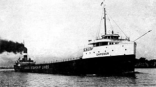
SS Emperor was a steel-hulled Canadian lake freighter in service between 1911 and 1947. She was built between 1910 and April 1911 by the Collingwood Shipbuilding Company in Collingwood, Ontario, for Inland Lines, Ltd., of Midland, Ontario. She entered service on May 3, 1911. Emperor was sold to Canada Steamship Lines of Montreal, Quebec. Under the ownership of Canada Steamship Lines, she carried a wide variety of cargoes, but most frequently iron ore to Point Edward, Ontario, where it would be transported to Hamilton, Ontario, by train. After the opening of the fourth Welland Canal, Emperor carried the ore directly to Hamilton. She was involved in several accidents throughout her career.
References
- 1 2 "Transportation, S.S.Iroquois". Sidney Museum & Archives. Archived from the original on 23 February 2012.
- 1 2 Chown, Diana (23 May 2011). "1911 Sinking of SS Iroquois". North Saanich Online. Archived from the original on 4 November 2011.
- ↑ "Iroquois Park". Town of Sidney. Archived from the original on 9 July 2014. Retrieved 21 August 2014.