Related Research Articles

Lauderdale County is a county located on the western edge of the U.S. state of Tennessee, with its border the Mississippi River. As of the 2010 census, the population was 27,815. Its county seat is Ripley. Since the antebellum years, it has been developed for cotton as a major commodity crop.

Calhoun County is a county located in the U.S. state of Mississippi. As of the 2010 census, the population was 14,962. Its county seat is Pittsboro. The county is named after John C. Calhoun, the U.S. Vice President and U.S. Senator from South Carolina.
The Loosahatchie River is a 64.0-mile-long (103.0 km) stream in southwestern Tennessee. Except for a few miles near its head, its mouth, and near the middle of its length, it has been entirely channelized, as have its major tributaries, for agriculture purposes. Its drainage basin was once the site of extensive cotton plantings, which have been greatly diminished in recent decades by extensive urbanization of the area.

The Hatchie River is a 238-mile-long (383 km) river in northern Mississippi and southwestern Tennessee. It is of considerable geographic, cultural, and historic significance. In large measure this is because it is the only major river of West Tennessee that has never been impounded, channelized, or otherwise modified by human activity to any major degree, although several of its tributaries have. Its environs are indicative of what much of West Tennessee must have resembled prior to the time of European settlement in early 19th century.
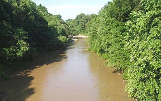
The Tuscumbia River is a 44.4-mile-long (71.5 km) tributary of the Hatchie River in northern Mississippi and western Tennessee in the United States. It rises in Prentiss County, Mississippi, near Booneville. It flows through Alcorn County, then into McNairy County, Tennessee, where it is joined by a major tributary, Cypress Creek, and then flows into the Hatchie River, just before it reaches Hardeman County, near Pocahontas, Tennessee.

The Skuna River is a tributary of the Yalobusha River, about 75 mi (120 km) long, in north-central Mississippi in the United States. Via the Yalobusha and Yazoo Rivers, it is part of the watershed of the Mississippi River.
Apookta Creek is a stream in the U.S. state of Mississippi. It is a tributary to the Big Black River.
Bagasha Creek is a stream in the U.S. state of Mississippi. It is a tributary to Zilpha Creek.
Besa Chitto Creek is a stream in the U.S. state of Mississippi. It is a tributary to the Yockanookany River.
Big Bogue is a stream in the U.S. state of Mississippi.
Bophumpa Creek is a stream in Holmes County in the U.S. state of Mississippi. It is a tributary to Fannegusha Creek.
Boughenia Creek is a stream in the U.S. state of Mississippi. It is a tributary to Sand Creek.
Butputter Creek is a stream in the U.S. state of Mississippi.
Bywy Creek is a stream in the U.S. state of Mississippi.
Calabrella Creek is a stream in the U.S. state of Mississippi. It is a tributary to the Big Black River.
Chuquatonchee Creek is a stream in Chickasaw, Clay and Pontotoc counties in the U.S. state of Mississippi. It is a tributary to Tibbee Creek.
Fannegusha Creek is a stream in Carroll and Holmes counties in east-central Mississippi. It is a tributary to the Blissdale Swamp.
Scoobachita Creek is a stream in the U.S. state of Mississippi.
Tibby Creek is a stream in the U.S. state of Mississippi. It is a tributary to the Yockanookany River.
Topashaw Creek is a stream in the U.S. state of Mississippi. It is a tributary to the Yalobusha River.
References
- 1 2 U.S. Geological Survey Geographic Names Information System: Sabougla Creek
- ↑ Baca, Keith A. (2007). Native American Place Names in Mississippi. University Press of Mississippi. p. 89. ISBN 978-1-60473-483-6.
Coordinates: 33°40′52″N89°21′19″W / 33.6811727°N 89.3552735°W
| This article related to a river in Mississippi is a stub. You can help Wikipedia by expanding it. |