Hertsmere is a local government district with borough status in Hertfordshire, England. Its council is based in Borehamwood. Other settlements in the borough include Bushey, Elstree, Radlett and Potters Bar. The borough contains several film studios, including Elstree Studios and the BBC Elstree Centre at Borehamwood. The borough borders Three Rivers, Watford, St Albans, and Welwyn Hatfield in Hertfordshire and the three north London boroughs of Harrow, Barnet and Enfield. Hertsmere is located mainly within the M25 Motorway.
The London Borough of Barnet, located on the northern periphery of London and having much of the area within its boundaries in the Metropolitan Green Belt, has many parks and open spaces. In addition there are large areas taken over by cemeteries and golf courses, and part of Hampstead Heath.

Staines Moor is a 510.8-hectare (1,262-acre) biological Site of Special Scientific Interest north of Staines-upon-Thames in Surrey. It is part of the South West London Waterbodies Ramsar site and a Special Protection Area

Rye Meads is a 58.5-hectare (145-acre) biological Site of Special Scientific Interest (SSSI) in Rye House, Hoddesdon, Hertfordshire. It is one of series of wetlands and reservoirs situated along the River Lea, to the north-east of London. It is part of the Lea Valley Ramsar site and a Special Protection Area.

Arkley is a village in Greater London, England, within the London Borough of Barnet. It is located 10.6 miles (17.1 km) north-northwest of Charing Cross.

Woodridge Nature Reserve or Woodridge School Nature Reserve is a 0.7-hectare (1.7-acre) Site of Local Importance for Nature Conservation in Woodside Park, London, owned and managed by the London Borough of Barnet. It was designed as a nature trail for local primary schools, but is now very neglected.

Rowley Green Common is a six hectare Local Nature Reserve and a Site of Importance Metropolitan for Nature Conservation in Arkley, north London. It is owned by the London Borough of Barnet. It is also registered common land.
Burtonhole Lane and Pasture is a 6.5-hectare (16-acre) Site of Borough Importance for Nature Conservation, Grade II, between Mill Hill and Totteridge in the London Borough of Barnet. It consists of Burtonhole Lane between Partingdale Lane and Burtonhole Close, a footpath east from Burtonhole Lane towards Folly Brook, two fields south of the footpath, and a narrow belt of privately owned woodland north of the footpath. Burtonhole Brook, a tributary of Folly Brook, crosses Burtonhole Lane and the fields.

Arrandene Open Space and Featherstone Hill is a 25 hectare Site of Metropolitan Importance for Nature Conservation in Mill Hill in the London Borough of Barnet.

Glebe Lane Pastures is a Site of Borough Importance for Nature Conservation, Grade I, in Arkley in the London Borough of Barnet.

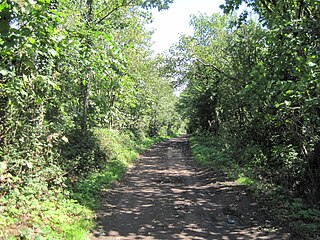
Arkley Lane and Pastures is a 50-hectare (120-acre) Site of Borough Importance for Nature Conservation, Grade II, in Arkley in the London Borough of Barnet. Arkley Lane, off Barnet Road, is an old drovers' road. Located on the Barnet Plateau, it is now a quiet country lane with a traditional bank and ditch. The thick hedges are composed of beech and hornbeam, ash, field maple and magnificent old pedunculate oaks.

Woodcock Hill Village Green or Woodcock Hill Open Space is an area of grass and woodland in Borehamwood in Hertfordshire in England. It was designated a Village Green in 2008 to prevent development of the site.

Yeading Brook Meadows is a 17 hectare Local Nature Reserve (LNR) in Yeading in the London Borough of Hillingdon. It is owned by Hillingdon Council and managed by the London Wildlife Trust (LWT). In the north it adjoins Ten Acre Wood across the Golden Bridge and Charville Lane; it then stretches south along the banks of the Yeading Brook to Yeading Lane. The reserve is also part of the Yeading Brook Meadows Site of Metropolitan Importance for Nature Conservation, which includes two neighbouring LNRs managed by the London Wildlife Trust, Ten Acre Wood and Gutteridge Wood and Meadows.

Sarratt Bottom nature Reserve in Hertfordshire is a 3.2-hectare (7.9-acre) biological Site of Special Scientific Interest. The site is a meadow beside the River Chess. It is an example of damp grassland which has been traditionally managed for grazing. There are also areas of swamp and marsh. The main plants in grassland areas include sweet vernal grass and meadow foxtail, and marsh horsetail and common spike-rush are common in damper areas. The site has hedgehogs and a wide variety of wetland birds and invertebrates.

Furzefield Wood and Lower Halfpenny is a 7.4 hectare Local Nature Reserve in Potters Bar in Hertfordshire. It is owned and managed by Hertsmere Borough Council.

Purwell Meadows is an 8.6-hectare (21-acre) nature reserve in Hitchin, Hertfordshire, England. It was declared a Local Nature Reserve in 1994. It is owned and managed by North Hertfordshire District Council.
Fisher's Field is a 1.8 hectare Local Nature Reserve (LNR) in Bushey in Hertfordshire. It is owned and managed by Hertsmere Borough Council.
Long Lane Pasture is a 1.1-hectare (2.7-acre) nature reserve in Finchley in the London Borough of Barnet. It is owned by Barnet Council and managed by the Long Lane Pasture Trust. The council does not contribute any funds to the Trust.

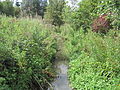
Potters Bar Brook is a 3.3 km (2.0 mi) long stream (brook) in Hertfordshire, England, that is a tributary to the Mimmshall Brook.

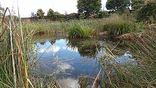
Mimmshall Brook is a 9.8 kilometres (6.1 mi) long stream (brook) in Greater London and Hertfordshire, England. Rising from two sources—one in Hertsmere, Hertfordshire, and the other in Arkley, London Borough of Barnet—the brook drains into a catchment area of 52 km2 (20 sq mi) at Water End Swallow Holes, Welham Green, North Mymms. It is a tributary of the River Colne.