
Lemont is a village located in Cook, DuPage, and Will counties in the U.S. state of Illinois, and is a suburb of Chicago. The population was 16,000 as of the 2010 census. Lemont is home to Argonne National Laboratory and other heavy industrial sites, and has a substantial European immigrant population.

An oak savanna is a type of savanna-or lightly forested grassland- where oaks are the dominant trees, the term oakery or woodlands is also used commonly, though the former is more prevalent when referencing the Mediterranean area. These savannas were maintained historically through wildfires set by lightning, humans, grazing, low precipitation, and/or poor soil.
The Calumet Region is the geographic area drained by the Grand Calumet River and the Little Calumet River of northeastern Illinois and northwestern Indiana in the United States. It is part of the Great Lakes Basin, which eventually reaches the Atlantic Ocean. It is a sub-region of the greater Northwest Indiana region and the even larger Great Lakes region.

The Site A/Plot M Disposal Site is located within Red Gate Woods and situated on the former grounds of Argonne National Laboratory and its predecessor, the University of Chicago Metallurgical Laboratory in Cook County, Illinois and is part of the Palos Forest Preserve. The site contains buried radioactive waste from contaminated building debris, and the Chicago Pile-1 (CP-1/CP-2), and Chicago Pile-3 (CP-3) nuclear reactors. "Site A" was an early Manhattan Project code for the facility. "Plot M" was later used for the disposal ground.
Archer Avenue, sometimes known as Archer Road outside the Chicago, Illinois city limits, and also known as State Street only in Lockport, Illinois and Fairmont, Illinois city limits, is a street running northeast-to-southwest between Chicago's Chinatown and Lockport. Archer follows the original trail crossing the Chicago Portage between the Chicago River and the Des Plaines River, and parallels the path of the Illinois and Michigan Canal and the Alton Railroad. As a main traffic artery, it has largely been replaced by the modern Stevenson Expressway.

The Forest Preserve District of Cook County is a governmental commission in Cook County, Illinois, that owns and manages a network of open spaces, containing forest, prairie, wetland, streams, and lakes, that are mostly set aside as natural areas. Cook County contains Chicago, and is the center of the most densely populated urban metropolitan area in the Midwest. The Forest Preserve lands encompass approximately 70,000 acres (280 km2), about 11% of the county, providing open space within its urban surroundings. It contains facilities for recreation, as well as a zoo and a botanic garden.

Sanborn County Park is a 3,453 acres (13.97 km2) public park situated in the Santa Cruz Mountains owned by the county of Santa Clara, California, adjacent to Castle Rock State Park and the Los Altos Rod and Gun Club Range and Santa Clara County Peace Officers Association gun range. The park is managed by the Santa Clara County Parks and Recreation Department. The park is heavily forested and offers hiking and other generally low intensity outdoor uses. The park lies between the town of Saratoga and the ridgetop road, Skyline Boulevard. In the summer months, Sanborn County Park hosts the only outdoor Shakespearean company in Silicon Valley.
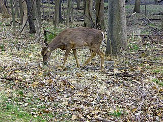
Red Gate Woods is a forest preserve section within the Palos Division of the Forest Preserve District of Cook County, Illinois. It is located near where the Cal-Sag Channel meets the Chicago Sanitary and Ship Canal. In the woods is the original site of Argonne National Laboratory and the Site A/Plot M Disposal Site, which contains the buried remains of Chicago Pile-1, the world's first nuclear reactor.

Barrington Township is one of 29 townships in Cook County, Illinois, USA. As of the 2010 census, its population was 15,636. The northwestern corner of the Cook County panhandle, it is the county's northwesternmost township. It is also by far the least densely populated township in the county, with less than half the population density of the next least Lemont Township.

Lemont Township is one of 29 townships in Cook County, Illinois, USA. As of the 2010 census, its population was 21,113.

Lyons Township is one of 29 townships in Cook County, Illinois, USA. As of the 2010 census, its population was 111,688. Lyons Township was established in 1850. The nearby village of Lyons is often incorrectly referred to as "Lyons Township"

Orland Township is one of 29 townships in Cook County, Illinois, USA. As of the 2010 census, its population was 97,558.

Downers Grove Township is one of nine townships in DuPage County, Illinois, USA. As of the 2010 census, its population was 146,795 and it contained 60,438 housing units. It is the largest township in the county, both in terms of area and population.

Zoar Valley is an area of deep gorges along the Main and South branches of Cattaraugus Creek in western New York, United States. The valley is located along the border of Erie County and Cattaraugus County, roughly between the villages of Gowanda to the west and Springville to the east.
The North Branch Trail is a Class I bicycle trail located in northeastern Cook County, Illinois. The trail starts at the western part of Gompers Park in Chicago, and from there it continues north approximately 22 miles (35 km) to Glencoe. The trail follows a path along the North Branch of the Chicago River, the Skokie River and the Skokie Lagoons.
The Forest Preserve District of Will County was created by referendum on July 25, 1927, to preserve open spaces in Will County, Illinois, US. The first land acquisition was in 1930. As of December 2010, the District owns or manages 21,916 acres (8,869 ha) of land. Current Will County board members make up a board of commissioners, which oversees the affairs of the Forest Preserve District.

The Palos Verdes Peninsula Land Conservancy (PVPLC) is a non-profit organization that is based on the Palos Verdes Peninsula in southwestern Los Angeles County, California.

Anchistea is a genus of leptosporangiate ferns in the family Blechnaceae. It has only one species, Anchistea virginica the Virginia chain fern, which has long creeping, scaly, underground stems or rhizomes giving rise to tall widely separated, deciduous, single leaves. In contrast, the leaves of Osmundastrum cinnamomeum, which can be mistaken for A. virginica, grow in a group from a crown. Also in contrast to O. cinnamomeum the leaves are monomorphic without distinct fertile fronds. The lower petiole or stipe is dark purple to black, shiny and swollen, the upper rachis is dull green. The leaf blade is green and lanceolate, composed of 12 to 23 paired, alternate pinnatifid pinnae. The pinnae are subdivided into 15 to 20 paired segments that are ovate to oblong. The lower rachis is naked for about half its length. The sori or spore-producing bodies are found on the underside of the pinnae and are long and form a double row which outlines the major veins of the pinnae. In common with all ferns, A. virginica exhibits a gametophyte stage in its life cycle and develops a haploid reproductive prothallus as an independent plant. The spores are produced in red-brown sori which line the spaces (areolae) between the costa and costules. Further photographs can be found at the Connecticut Botanical Society and Ontario Ferns websites.

Sag Bridge, Illinois is a populated place in southwestern Cook County, Illinois. Sag Bridge is an important waterway junction between the Calumet Sag Channel and the Chicago Sanitary and Ship Canal. It is also the junction of IL 83 and IL 171 which meet at Sag Bridge to cross the Calumet Sag Channel together on the eponymous bridge. The community was named for a predecessor of the present bridge. It is within the village limits and postal delivery zone of Lemont, Illinois.
Dr. Floyd Allen Swink (1921-2000) was an American botanist, teacher of natural history, and author of several floras of the Chicago region.
