Related Research Articles

The greater sage-grouse, also known as the sagehen, is the largest grouse in North America. Its range is sagebrush country in the western United States and southern Alberta and Saskatchewan, Canada. It was known as simply the sage grouse until the Gunnison sage-grouse was recognized as a separate species in 2000. The Mono Basin population of sage grouse may also be distinct.
Lemmon Valley is a census-designated place (CDP) in Washoe County, Nevada, United States. The population was 5,040 at the 2010 census. It is a northern suburb of the city of Reno and is part of the Reno–Sparks Metropolitan Statistical Area. Prior to 2010 it was listed by the U.S. Census Bureau as part of the Lemmon Valley–Golden Valley CDP.
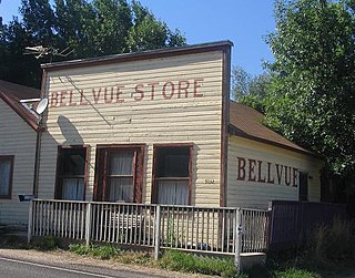
Bellvue is an unincorporated community and U.S. Post Office in Larimer County, Colorado. It is a small agricultural community located in Pleasant Valley, a narrow valley just northwest of Fort Collins near the mouth of the Poudre Canyon between the Dakota Hogback ridge and the foothills of the Rocky Mountains. The ZIP Code of the Bellvue Post Office is 80512.
The Pine Nut Mountains are a north–south mountain range in the Great Basin, in Douglas and Lyon counties of northwestern Nevada, United States. The highest mountain in the range is Mount Siegel at 9,456 ft.
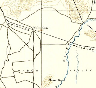
Wabuska is an unincorporated community in Lyon County, Nevada, United States. The zip code is 89447, which it shares with nearby Yerington.
Golden Valley is a census-designated place (CDP) in Washoe County, Nevada, United States. The population was 1,556 at the 2010 census. It is a northern suburb of the city of Reno and is part of the Reno–Sparks Metropolitan Statistical Area. Prior to 2010, it was listed by the U.S. Census Bureau as part of the Lemmon Valley–Golden Valley CDP.

The Washoe Valley is a geographical region in the United States covering 66 square miles (170 km2) in southern Washoe County in the state of Nevada. Located between Reno and Carson City, it is named for the Washoe people, Native Americans who lived there before the arrival of Europeans. Slide Mountain and Mount Rose overlook the valley from the west.
Genevra is an unincorporated community in Colusa County, California. It lies at an elevation of 98 feet. The place was named Berlin in the 1870s by officials of the Southern Pacific Railroad on whose tracks it was established. The post office was established in 1876, and renamed from Berlin to Genevra during World War I; the post office closed in 1934.
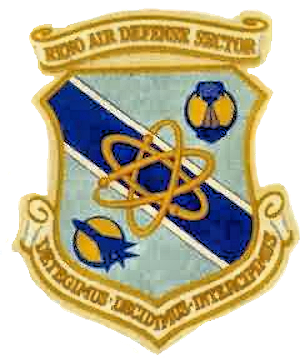
The Reno Air Defense Sector (ReADS) is an inactive United States Air Force organization. Its last assignment was with the 28th Air Division, being stationed at Stead Air Force Base, Nevada.
Yokohl Valley is an unincorporated community in Tulare County, California. It lies at an elevation of 463 feet. Currently, the Yokohl Valley area constitutes the most eastern part of Exeter, CA along the foothills. Yokohl Valley may be reached through Rocky Hill Rd from the west, Myer Dr from the south and Yokohl Dr from the north off CA Hwy 198.
Little Smoky Valley is one of the Central Nevada Desert Basins and an eponym for the larger Little Smoky-Newark Watershed. The valley spans three counties in Nevada, namely Eureka, Nye, and White Pine.
Hualapai Flat is a valley in northwestern Nevada, United States, located northwest of the Black Rock Desert. The two valleys are separated by the Calico Hills. The Granite Range marks the southern and western edges of Hualapai Flat. To the north the valley is constrained by the Granite Range and the Calico Hills. Washoe, Pershing, and Humboldt counties meet in the Hualapai Flat.
Deep Creek Valley is a 35-mile (56 km) long valley located in southwest Tooele County at the Utah-Nevada border; the extreme south of the valley is in northwest Juab County. The valley parallels the west flank of the Deep Creek Range, both north-trending. In the north-northeast, its outlet widens into the southwest of the Great Salt Lake Desert region.

The Mason Valley is a valley in western Nevada, between the Singatse Range and the Wassuk Range in Lyon County, Nevada.
Dustin is an unincorporated community in Holt County, Nebraska, United States.
Harrington is an unincorporated community in Bennett County, in the U.S. state of South Dakota.
Gettman Hollow is a valley in Taney County in the Ozarks of southwestern Missouri. Gettman Hollow is a tributary to Bull Creek.
Centerville is an unincorporated community in Douglas County, in the U.S. state of Nevada. The community is at the intersection of Nevada routes 88 and 756 approximately two miles south-southwest of Minden.
Jacks Valley is a valley in the U.S. state of Nevada.
White Sage Flat is a flat in Elko County, Nevada and Tooele County, Utah.
References
- 1 2 U.S. Geological Survey Geographic Names Information System: Sage Hen Valley
- ↑ Federal Writers' Project (1941). Origin of Place Names: Nevada (PDF). W.P.A. p. 65.
40°04′12″N119°10′16″W / 40.07000°N 119.17111°W
| | This Churchill County, Nevada state location article is a stub. You can help Wikipedia by expanding it. |
| | This Pershing County, Nevada state location article is a stub. You can help Wikipedia by expanding it. |