Le Haut-Saint-François is a regional county municipality in southeastern Quebec, Canada in the Estrie region. Its seat is in Cookshire-Eaton, and it is named for the Saint-François River which runs through the RCM.

L'Islet is a municipality within L'Islet Regional County Municipality in the Chaudière-Appalaches region of Quebec, Canada.

Beauceville is a city in, and the seat of, the Municipalité régionale de comté Beauce-Centre in Quebec, Canada. It is part of the Chaudière-Appalaches region and the population was 6,185 as of the Canada 2021 Census.
Saint-Odilon-de-Cranbourne is a municipality in Beauce-Centre Regional County Municipality in the Chaudière-Appalaches region of Quebec, Canada. Its population is 1,407 as of the Canada 2021 Census. The municipality's name honours Reverend Pierre-François-Xavier-Odilon-Marie-Alphonse Paradis, the first priest of Saint-Odilon-de-Cranbourne, while "Cranbourne" comes from Cranborne, a village in East Dorset, England.

Bonsecours is a municipality in Le Val-Saint-François Regional County Municipality in the Estrie region of Quebec, Canada.

Weedon is a municipality of 2,667 people in Le Haut-Saint-François Regional County Municipality, in Quebec, Canada.

La Patrie is a municipality of about 815 people in Le Haut-Saint-François Regional County Municipality, in Quebec, Canada. It is located at the base of Mont Mégantic.

Dudswell is a municipality of 1,700 people in Le Haut-Saint-François Regional County Municipality, in Quebec, Canada.

Saint-Isidore-de-Clifton is a municipality of 700 people in Le Haut-Saint-François Regional County Municipality, in Quebec, Canada on the Canada–United States border. Saint-Isidore-de-Clifton is the source of the Eaton and Clifton rivers.

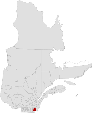
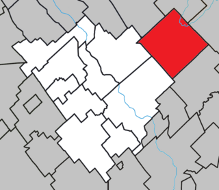
Newport is a municipality of about 700 people in Le Haut-Saint-François Regional County Municipality, in Quebec, Canada. Newport has a small town called Island Brook.

Pierreville is a municipality in Nicolet-Yamaska Regional County Municipality, Quebec, located at the confluence of the Saint Lawrence and Saint-François rivers, at the edge of Lac Saint-Pierre. The population as of the Canada 2011 Census was 2,176.
Saint-Onésime-d'Ixworth is a municipality in the Canadian province of Quebec, located in the Kamouraska Regional County Municipality.

Saint-Philibert is a municipality in the Municipalité régionale de comté de Beauce-Sartigan in Quebec, Canada. It is part of the Chaudière-Appalaches region. The population is 379 as of 2021. It is named after reverend François-Philibert Lamontagne, who promoted the parish at the time of the church construction in 1919.

Saint-Épiphane is a municipality in Quebec in the administrative region of Bas-Saint-Laurent and the regional county municipality of Rivière-du-Loup.

Saint-François-de-la-Rivière-du-Sud is a municipality in Quebec.

Saint-François-Xavier-de-Brompton is a municipality in Le Val-Saint-François Regional County Municipality in the Estrie region of Quebec, Canada. Prior to November 16, 2013 it was a parish municipality.

Saint-Denis-de-Brompton is a municipality in the Canadian province of Quebec, part of the Regional County Municipality of Le Val-Saint-François, within the larger administrative region of Estrie. It is located approximately 145 kilometres east of Montreal. The municipality is located in a densely wooded area on the shores of Lake Brompton.

Racine is a municipality in Quebec, Canada. It is located in the Le Val-Saint-François Regional County Municipality, in the administrative region of Estrie. It is named after Antoine Racine, the first Bishop of Sherbrooke.

Ulverton is a municipality in Le Val-Saint-François Regional County Municipality in the Estrie region of Quebec, Canada.

Kataskomiq is an Indian reserve listed by the Canadian Geographical Names Database. The reserve belongs to the Wolastoqiyik Wahsipekuk (Viger) First Nation, Maliseet people. It is not listed by Indigenous and Northern Affairs Canada or the last two Canadian census. It is located in the Bas-Saint-Laurent region of Quebec, geographically located within the territory of Rivière-du-Loup Regional County Municipality but is not legally part of it. Its population was 0 in the 2006 Canadian census and does not appear in either the 2011 or 2016 Canadian Census. Before 2021 it was known as Whitworth.


