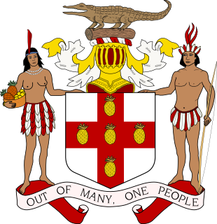
Politics in Jamaica takes place in the framework of a representative parliamentary democratic constitutional monarchy. The 1962 Constitution of Jamaica established a parliamentary system whose political and legal traditions closely follow those of the United Kingdom. As the head of state, Queen Elizabeth II - on the advice of the Prime Minister of Jamaica - appoints a governor-general as her representative in Jamaica. The governor-general has a largely ceremonial role. Jamaica constitutes an independent Commonwealth realm.

Saint Ann is the largest parish in Jamaica. It is situated on the north coast of the island, in the county of Middlesex, roughly halfway between the eastern and western ends of the island. It is often called "the Garden Parish of Jamaica" on account of its natural floral beauty. Its capital is Saint Ann's Bay. Saint Ann comprises New Seville, the first Spanish Settlement in Jamaica.

Saint Thomas, once known as Saint Thomas in the East, is a suburban parish situated at the south eastern end of Jamaica, within the county of Surrey. It is the birthplace of the Right Honourable Paul Bogle, designated in 1969 as one of Jamaica's seven National Heroes. Morant Bay, its chief town and capital, is the site of the Morant Bay Rebellion in 1865, of which Bogle was a leader.

St Catherine is a parish in the south east of Jamaica. It is located in the county of Middlesex, and is one of the island's largest and most economically valued parishes because of its many resources. It includes the first capital of Jamaica, Spanish Town, originally known as San Jago de la Vega or Santiago de la Vega.

Saint Elizabeth, one of Jamaica's largest parishes, is located in the southwest of the island, in the county of Cornwall. Its capital, Black River, is located at the mouth of the Black River, the widest on the island.

Saint Andrew is a parish, situated in the southeast of Jamaica in the county of Surrey. It lies north, west and east of Kingston, and stretches into the Blue Mountains. In the 2011 census, it had 573,369, the highest population of any of the parishes in Jamaica. George William Gordon, one of Jamaica's seven National Heroes, was born in this parish.
The following is an alphabetical list of topics related to the nation of Jamaica.

The effects of Hurricane Charley in Jamaica included one fatality and at least $1 million in damages. Forming out of a tropical wave on August 9, 2004, Charley quickly tracked through the eastern Caribbean Sea and attained tropical storm status on August 10. While passing south of Jamaica on August 11, the storm was upgraded to a Category 1 hurricane. During its passage of Jamaica, Charley had maximum winds of 75 mph (120 km/h), a low-end Category 1 hurricane. Turning north, the storm impacted western Cuba as a Category 3 storm before making landfall in Florida as a strong Category 4. The storm eventually dissipated on August 15. As Charley approached Jamaica, officials issued tropical storm watches and warnings before issuing a hurricane watch. Two cruise ships were diverted from docking in Jamaica, affecting 5,700 passengers. Numerous shelters were set up across the island; however, relatively few people sought refuge in them.

Saint Ann's Bay is a settlement in Jamaica, the capital of Saint Ann Parish. It has a population of 13,671 as of 2009.

Saint David Parish was one of the historic parishes of Jamaica created following colonisation of the island by the British. It was in the east of the island in Surrey County
Metcalfe Parish was one of the historic parishes of Jamaica. It takes its name from Governor Metcalfe. It was in the north side of the island in Middlesex County but was abolished in 1866 when it became part of Saint Mary Parish.
Saint Dorothy Parish was one of the historic parishes of Jamaica created following colonisation of the island by the British. It was on the south side of the island in Middlesex County to the west of Port Royal and Kingston but was abolished in 1866 when it was merged into Saint Catherine Parish.
Saint John Parish was one of the historic parishes of Jamaica created following colonisation of the island by the British. It was in the centre of the island in Middlesex County but was abolished in 1866 when it was merged into Saint Catherine Parish.
Vere Parish was one of the historic parishes of Jamaica created following colonisation of the island by the British. It was in the south of the island in Middlesex County but was abolished in 1866 when it was merged into Clarendon Parish.
Saint Thomas in the Vale Parish was one of the historic parishes of Jamaica created following colonisation of the island by the British. It was in the centre of the island in Middlesex County but was abolished in 1866 when it was merged into Saint Catherine Parish.
Wentworth Bayly was the owner of the Gibraltar estate in Saint George Parish, Jamaica. He was elected to the House of Assembly of Jamaica in 1820. He died at Weston Hall, Suffolk. His will is held at the British National Archives.
Francis Rose was a plantation owner in Jamaica. He was active in the politics of the island and was elected to serve in the House of Assembly of Jamaica multiple times, becoming speaker in 1702, and later president of the Council of Jamaica.

The 1944 Jamaica hurricane was a deadly major hurricane that swept across the Caribbean Sea and Gulf of Mexico in August 1944. Conservative estimates placed the storm's death toll at 116. The storm was already well-developed when it was first noted passing westward over the Windward Islands into the Caribbean Sea on August 16. A ship near Grenada with 74 occupants was lost, constituting a plurality of the deaths associated with the storm. The following day, the storm intensified into a hurricane, reaching its peak strength on August 20 with maximum sustained winds of 120 mph (195 km/h). At this intensity, the major hurricane made landfall on Jamaica later that day, traversing the length of the island. The damage wrought was extensive, with the strong winds destroying 90 percent of banana trees and 41 percent of coconut trees in Jamaica; the overall damage toll was estimated at "several millions of dollars". The northern coast of Jamaica saw the most severe damage, with widespread structural damage and numerous homes destroyed across several parishes. In Port Maria, the storm was considered the worst since 1903.


