The parishes of Jamaica are the main units of local government in Jamaica. They were created following the English settlement of Jamaica in 1655. This administrative structure for the Colony of Jamaica developed slowly. However, since 1 May 1867, Jamaica has been divided into the current fourteen parishes. These were retained after independence in 1962. They are grouped into three historic counties, which no longer have any administrative relevance. Every parish has a coast; none are landlocked.

Saint Thomas, once known as Saint Thomas in the East, is a suburban parish situated at the south eastern end of Jamaica, within the county of Surrey. It is the birthplace of Paul Bogle, designated in 1969 as one of Jamaica's seven National Heroes. Morant Bay, its chief town and capital, is the site of the Morant Bay Rebellion in 1865, of which Bogle was a leader.

Saint Mary is a parish located in the northeast section of Jamaica. With a population of 114,227 it is one of Jamaica's smallest parishes, located in the county of Middlesex. Its chief town and capital is Port Maria, located on the coast.

Portland, with its capital town Port Antonio, is a parish located on Jamaica's northeast coast. It is situated to the north of St Thomas and to the east of St Mary in Surrey County. It is one of the rural areas of Jamaica, containing part of the Blue Mountains, where the Jamaican Maroon communities of Moore Town and Charles Town are located.

Saint Andrew is a parish, situated in the southeast of Jamaica in the county of Surrey. It lies north, west and east of Kingston, and stretches into the Blue Mountains. As of the 2011 census, it had a population of 573,369, the highest of any of the parishes in Jamaica.
Aeolus Valley is a village in the Yallahs district of the Jamaican parish of Saint Thomas. Although there has been a recent wave of violence and murders, residents still say that the community is a wonderful place.
Airy Castle is a village in the Jamaican parish of Saint Thomas.
Port Morant is a town in Saint Thomas Parish, southeastern Jamaica. It was, in the early years of European settlement, one of the island's chief ports, with export of bananas and production of rum being major industries. Following the English conquest of Jamaica in 1655, General Luke Stokes arrived from Nevis with 1,600 people who settled near Port Morant in 1656.
Hopewell Hall is a settlement in Saint Thomas Parish, Jamaica.
The Plantain Garden River is a river in the parish of St Thomas on the island of Jamaica. It is the only major river in Jamaica that does not flow in a northerly or southerly direction.
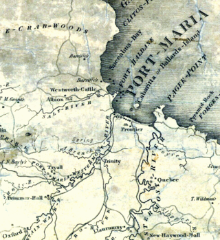
The Otram River, formerly known as the Port Maria River or the Port Maria Western River, is a river in Saint Mary Parish, Jamaica. It reaches the sea in the parish capital of Port Maria and contributes to flooding in that town.
Golden Grove is a settlement in the parish of Saint Thomas, Jamaica. Historically a sugar plantation, it had a population of 3,057 in 2009.
Gordon Town is a settlement in Saint Andrew Parish, Jamaica. It has a population of 1,067 as of 2009. Reggae musician Judah Eskender Tafari was born in Gordon Town, as was Henry Arthur Campbell (1873-1953), electrical engineer.
Hardwar Gap is a natural gap located in the Blue Mountains, on the border between Saint Andrew Parish and Portland Parish. It lies at an elevation of 1,220 metres (4,000 ft), and was named for Captain Hardwar, a British army captain who was supervising the construction of the road that cuts from this gap to Buff Bay.

The Gleaner is an English-language, morning daily newspaper founded by two brothers, Jacob and Joshua de Cordova on 13 September 1834 in Kingston, Jamaica. Originally called the Daily Gleaner, the name was changed on 7 December 1992 to The Gleaner. The newspaper is owned and published by Gleaner Company publishing house in Kingston, Jamaica. The Gleaner is considered a newspaper of record for Jamaica.
Hellshire Hills is a region of dry limestone hills in Saint Catherine Parish, Jamaica, which forms part of the Portland Bight Protected Area.

Saint David Parish was one of the historic parishes of Jamaica created following colonisation of the island by the British. It was in the east of the island in Surrey County
Saint Dorothy Parish was one of the historic parishes of Jamaica created following colonisation of the island by the British. It was on the south side of the island in Middlesex County to the west of Port Royal and Kingston but was abolished in 1866 when it was merged into Saint Catherine Parish.

Albion was a sugar plantation in Saint David Parish, Jamaica. Created during or before the 18th century, it had at least 451 slaves when slavery was abolished in most of the British Empire in 1833. By the end of the 19th-century it was the most productive plantation in Jamaica due to the advanced refining technology it used. By the early 20th century, however, its cane sugar could not compete with cheaper European beet sugar, and it produced its last sugar crop in 1928. It subsequently became a banana farm for the United Fruit Company.
