Sainte-Anne-de-Sorel

Last updated
Sainte-Anne-de-Sorel
Municipality
Chenal du Moine.jpg
Sainte-Anne-de-Sorel Quebec location diagram.PNG
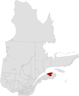
Location within Pierre-De Saurel RCM
Canada Southern Quebec location map.png
Red pog.svg
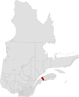
Sainte-Anne-de-Sorel
Location in southern Quebec
Coordinates: 46°03′N73°04′W / 46.050°N 73.067°W / 46.050; -73.067 Coordinates: 46°03′N73°04′W / 46.050°N 73.067°W / 46.050; -73.067 [1]
CountryFlag of Canada.svg  Canada
Province Flag of Quebec.svg  Quebec
Region Montérégie
RCM Pierre-De Saurel
Constituted May 14, 1877
Government [2] [3]
  Mayor Michel Péloquin
   Federal riding Bécancour—Nicolet—Saurel
   Prov. riding Richelieu
Area [2] [4]
  Total 59.10 km2 (22.82 sq mi)
  Land 38.39 km2 (14.82 sq mi)
Population (2011) [4]
  Total 2,742
  Density 71.4/km2 (185/sq mi)
  Pop 2006-2011Decrease2.svg 0.1%
  Dwellings 1,412
Time zone EST (UTC−5)
  Summer (DST) EDT (UTC−4)
Postal code(s) J3P 5N3
Area code(s) 450 and 579
Highways No major routes
Website www.sainteannedesorel.ca

Sainte-Anne-de-Sorel is a municipality in the Pierre-De Saurel Regional County Municipality, in the Montérégie region of Quebec. The community consists of a mainland section along with several islands extending into Lac Saint-Pierre. The population as of the Canada 2011 Census was 2,742, which makes it the largest municipality and the second largest urban division of the RCM.

Pierre-De Saurel Regional County Municipality Regional county municipality in Quebec, Canada

Pierre-De Saurel is a regional county municipality in the Montérégie region in southwestern Quebec, Canada. Originally named Le Bas-Richelieu Regional County Municipality, the name change to Pierre-De Saurel took effect on January 1, 2009. Its seat is in Sorel-Tracy. It is located on the Richelieu River, downstream from La Vallée-du-Richelieu Regional County Municipality at the confluence of the Richelieu and Saint Lawrence River.

Montérégie Administrative region in Quebec, Canada

Montérégie is an administrative region in the southwest part of Quebec. It includes the cities of Boucherville, Brossard, Granby, Longueuil, Salaberry-de-Valleyfield, Saint-Jean-sur-Richelieu, Saint-Hyacinthe, Sorel-Tracy, and Vaudreuil-Dorion.

Quebec Province of Canada

Quebec is one of the thirteen provinces and territories of Canada. It is bordered to the west by the province of Ontario and the bodies of water James Bay and Hudson Bay; to the north by Hudson Strait and Ungava Bay; to the east by the Gulf of Saint Lawrence and the province of Newfoundland and Labrador; and to the south by the province of New Brunswick and the U.S. states of Maine, New Hampshire, Vermont, and New York. It also shares maritime borders with Nunavut, Prince Edward Island, and Nova Scotia. Quebec is Canada's largest province by area and its second-largest administrative division; only the territory of Nunavut is larger. It is historically and politically considered to be part of Central Canada.

Contents

From 2006 throughout 2010 there has been much speculation about Sainte-Anne willing to merge into Sorel-Tracy to become a district (much like the former Saint-Pierre-de-Sorel and Tracy municipalities), however at the present time there has been no future talk about it at both city halls. The RCM planning administration is against the merger though, as it would compromise development potential in Sainte-Anne in favor of Sorel, since property evaluation services would be unified.

Demographics

See also

Related Research Articles

Abitibi Regional County Municipality Regional county municipality in Quebec, Canada

Abitibi Regional County Municipality is a regional county municipality in the Abitibi-Témiscamingue region of Quebec. The seat is Amos.

Antoine-Labelle Regional County Municipality Regional county municipality in Quebec, Canada

Antoine-Labelle is a regional county municipality located in the Laurentides region of Quebec, Canada. Its seat is Mont-Laurier. It is named for Antoine Labelle.

Beauharnois-Salaberry Regional County Municipality Regional county municipality in Quebec, Canada

Beauharnois-Salaberry is a regional county municipality in the Montérégie region of Quebec, Canada. Its seat is Beauharnois.

La Haute-Gaspésie Regional County Municipality Regional county municipality in Quebec, Canada

La Haute-Gaspésie is a regional county municipality in the Gaspésie–Îles-de-la-Madeleine region of eastern Quebec, Canada, on the Gaspé peninsula. The regional county municipality seat is in Sainte-Anne-des-Monts.

Francheville was a former regional county municipality in the Mauricie region of Quebec, Canada. Prior to its dissolution, it had an area of 1,124 square kilometres (434 sq mi).

La Mitis Regional County Municipality Regional county municipality in Quebec, Canada

La Mitis is a regional county municipality in the Bas-Saint-Laurent region in eastern Quebec, Canada on the Gaspé peninsula. It is named for the Mitis River which has its source in the region and flows through the central part of the region before emptying into the Saint Lawrence River.

La Vallée-du-Richelieu Regional County Municipality Regional county municipality in Quebec, Canada

La Vallée-du-Richelieu(The Valley of the Richelieu) is a regional county municipality in the Montérégie region in southwestern Quebec, Canada. Its seat is McMasterville.

LÎle-dOrléans Regional County Municipality Regional county municipality in Quebec, Canada

L'Île-d'Orléans is a regional county municipality in central Quebec, Canada, in the Capitale-Nationale region. Its seat is Sainte-Famille. The population in the 2011 census was 6,711 persons.

Maskinongé Regional County Municipality Regional county municipality in Quebec, Canada

Maskinongé is a regional county municipality in the Mauricie region of Quebec, Canada. The seat is Louiseville. It is located adjacent on the west of Trois-Rivières on the Saint Lawrence River.

Thérèse-De Blainville Regional County Municipality Regional county municipality in Quebec, Canada

Thérèse-De Blainville is a regional county municipality in the Laurentides region of Quebec, Canada. It is located immediately north of Laval on the north shore of the Rivière des Mille-Îles.

Sorel-Tracy City in Quebec, Canada

Sorel-Tracy is a city in southwestern Quebec, Canada and the geographical end point of the Champlain Valley at the confluence of the Richelieu River and the St. Lawrence River, on the western edge of Lac Saint-Pierre downstream and east of nearby Montreal. The population as of the Canada 2011 Census was 34,600. Its mayor is Serge Péloquin and it is the seat of the Pierre-De Saurel Regional County Municipality and the judicial district of Richelieu.

Le Haut-Saint-Laurent Regional County Municipality Regional county municipality in Quebec, Canada

Le Haut-Saint-Laurent(Upper Saint Lawrence) is a regional county municipality in southwestern Quebec, Canada, in the Montérégie region. Its seat is in Huntingdon and it is named for the Saint Lawrence River which forms its western and northwestern boundary.

Les Chenaux Regional County Municipality Regional county municipality in Quebec, Canada

Les Chenaux is a regional county municipality in central Quebec, Canada, in the Mauricie region. The seat is in Saint-Luc-de-Vincennes. It is located adjacent on the east of Trois-Rivières on the Saint Lawrence River. It has a land area of 872.04 square kilometres (336.70 sq mi) and a population of 17,865 inhabitants in the Canada 2011 Census. Its largest community is the parish of Notre-Dame-du-Mont-Carmel.

Sainte-Anne-de-la-Pérade Municipality in Quebec, Canada

Sainte-Anne-de-la-Pérade is a municipality in the Les Chenaux Regional County Municipality, in the Mauricie region of the province of Quebec in Canada. The town is located near the mouth of the Sainte-Anne River along the Chemin du Roy, a historic segment of Quebec Route 138 that stretches from near Montreal to Quebec City.

Saint-Robert, Quebec Municipality in Quebec, Canada

Saint-Robert is a municipality southeast of Sorel-Tracy in the Regional county municipality of Pierre-De Saurel, in Montérégie, Quebec. The population as of the Canada 2011 Census was 1,794. About 20 meteorites from the St-Robert meteorite shower were found here.

Sainte-Geneviève-de-Batiscan Parish municipality in Quebec, Canada

Sainte-Geneviève-de-Batiscan is a parish municipality in the Mauricie region of the province of Quebec in Canada. This municipality is part of the Les Chenaux Regional County Municipality in Batiscanie and in the administrative region of Mauricie. It is located along the Batiscan River.

Sainte-Anne-des-Monts, Quebec City in Quebec, Canada

Sainte-Anne-des-Monts is a city in the Gaspésie–Îles-de-la-Madeleine region of the province of Quebec in Canada.

Sainte-Victoire-de-Sorel, Quebec Municipality in Quebec, Canada

Sainte-Victoire-de-Sorel is a municipality located in the Pierre-De Saurel Regional County Municipality of Quebec (Canada), in the administrative region of Montérégie. The population as of the Canada 2011 Census was 2,501.

Saint-Joseph-de-Sorel City in Quebec, Canada

Saint-Joseph-de-Sorel is a town in the Regional county municipality of Pierre-De Saurel, in Montérégie, Quebec. It is located north of the Tracy section of Sorel-Tracy. Champlain Street marks the town's southern limit from Sorel-Tracy, and the rest of the town is surrounded by water.

References