Kigali is the capital and largest city of Rwanda. It is near the nation's geographic centre in a region of rolling hills, with a series of valleys and ridges joined by steep slopes. As a primate city, Kigali is a relatively new city. It has been Rwanda's economic, cultural, and transport hub since it was founded as an administrative outpost in 1907, and became the capital of the country at independence in 1962, shifting focus away from Huye.

Goma is the capital and largest city of the North Kivu Province in the eastern region of the Democratic Republic of the Congo (DRC). It is located on the northern shore of Lake Kivu, next to the Rwandan city of Gisenyi. It shares its borders with Bukumu Chiefdom to the north, Rwanda to the east, Masisi Territory to the west, and is flanked by Lake Kivu to the south. The city lies in the Albertine Rift, the western branch of the East African Rift System, and is only 13–18 km (8.1–11.2 mi) south of the active Nyiragongo Volcano. With an approximate area of 75.72 square kilometers, the city has an estimated population of nearly 2 million people according to the 2022 census, while the 1984 estimate placed the number at 80,000.
Rukira is a sector (imirenge), in Ngoma District, Eastern Province in Rwanda, with a population of 29,893 and an area of 58.55 square kilometers.

Kibungo is a town and sector in the Republic of Rwanda. It is the political, administrative and commercial capital of Ngoma District. In 1998, Kibungo became the site of at least four of Rwanda's last 22 executions. All of the convicts were executed for crimes related to the 1994 genocide.

Eastern Province is the largest, the most populous and the least densely populated of Rwanda's five provinces. It was created in early January 2006 as part of a government decentralization program that re-organized the country's local government structures.

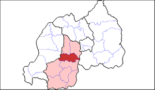
Ngoma is a district (akarere) in Eastern Province, Rwanda. Its capital is Kibungo.
The five provinces of Rwanda are divided into 30 districts. Each district is in turn divided into sectors, which are in turn divided into cells, which are in turn divided into villages.

Nyagatare is the largest and second most populous district (akarere) in Rwanda. Located in Eastern Province, Rwanda, it occupies the northeastern extremity of Rwanda. Its capital is Nyagatare City, the former capital of the now defunct Umutara province. Nyagatare District borders Uganda in the North, Tanzania in the East, Gatsibo District of the in the South, and Gicumbi District of the Northern Province in the West. Nyagatare has an area of 1741 km2, what makes it the largest district in Rwanda. With a population of 466,944 in 2012, and 653,861 in 2023, Nyagatare is the second most populated district of Rwanda only after Gasabo District of Kigali City with 879,505 inhabitants. This is a 156% increase from 2002 when the population was only 255,104. This sharp rise in the population is mainly due to the major movement of the population from other parts of the country in search of land.

Rulindo is a district (akarere) in Northern Province, Rwanda. Its capital is Tare.

Huye is one of the eight districts (Akarere) that make up Rwanda's Southern Province. It has a total surface area of 581.6 square Kilometers. It has thirteen sectors and 77 cells with a total of 508 umudugudus (villages) in total. The district has a population of 381,900, with an average of 660 inhabitants per square kilometer. The largest city in the province is Butare.

Nyaruguru is a district (akarere) in Southern Province, Rwanda. Its capital is Kibeho, a pilgrimage site of the Catholic Church.
Ruhango is a district (akarere) in Southern Province, Rwanda. Its capital is Ruhango town, a large settlement on the road between Gitarama and Butare.

Kicukiro District is one of the three Districts which constitute the City of Kigali and is situated in the South-East of the City of Kigali. Is a district (akarere) located in Kigali Province, Rwanda. Kicukiro is home to a thriving market, a number of NGOs(Non-Government Organizations) and the Bralirwa Brewery. In addition, it is the headquarters for the Friends Church in Rwanda. Kicukiro District is also home to two major memorial sites associated with the Rwandan genocide. These are the Rebero Genocide Memorial Site where 14,400 victims are buried, and the Nyanza Genocide Memorial Site where 5,000 victims were killed after Belgian soldiers who were serving in the United Nations peacekeeping forces abandoned them.

Nyarugenge is a district (akarere) in Kigali Province, Rwanda. Its heart is the city centre of Kigali, and contains most of the city's businesses.

I&M Bank Rwanda Plc., is a commercial bank in Rwanda that is licensed by the National Bank of Rwanda. It is the second largest bank in Rwanda.

Nyamata is a town and sector in the Bugesera District, southeastern Rwanda. Nyamata literally means 'place of milk' from the two Kinyarwanda words nya- 'of' and amata 'milk'. It is the location of the Nyamata Genocide Memorial, commemorating the Rwandan genocide of 1994.
Ruhango is a sector and town in Southern Province, Rwanda. The town is the capital of the Ruhango District.
Zaza is a sector in Rwanda to the east of Lake Mugesera and about 10 miles (16 km) west of Kibungo. It is located in the Ngoma District of the Eastern Province of Rwanda.
Ngoma is one of the sectors of Rulindo District in the northern province of Rwanda. The sector office is built between Busizi and Kiboha. It is on the top hill going from Jali of Gasabo District in the City of Kigali to Mugote and Remera