The history of Togo can be traced to archaeological finds which indicate that ancient local tribes were able to produce pottery and process tin. During the period from the 11th century to the 16th century, the Ewé, the Mina, the Gun, and various other tribes entered the region. Most of them settled in coastal areas. The Portuguese arrived in the late 15th century, followed by other European powers. Until the 19th century, the coastal region was a major slave trade centre, earning Togo and the surrounding region the name "The Slave Coast".

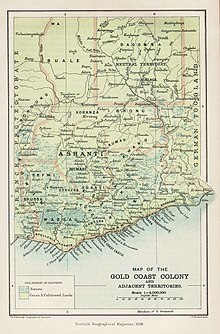
The Gold Coast was a British Crown colony on the Gulf of Guinea in West Africa from 1821 until its independence in 1957 as Ghana. The term Gold Coast is also often used to describe all of the four separate jurisdictions that were under the administration of the Governor of the Gold Coast. These were the Gold Coast itself, Ashanti, the Northern Territories protectorate and the British Togoland trust territory.

German Samoa was a German protectorate from 1900 to 1920, consisting of the islands of Upolu, Savai'i, Apolima and Manono, now wholly within the Independent State of Samoa, formerly Western Samoa. Samoa was the last German colonial acquisition in the Pacific basin, received following the Tripartite Convention signed at Washington on 2 December 1899 with ratifications exchanged on 16 February 1900. It was the only German colony in the Pacific, aside from the Jiaozhou Bay Leased Territory in China, that was administered separately from German New Guinea.

British Togoland, officially the Mandate Territory of Togoland and later officially the Trust Territory of Togoland, was a territory in West Africa under the administration of the United Kingdom, which subsequently entered a union with Ghana, part of which became its Volta Region. The territory was effectively formed in 1916 by the splitting of the German protectorate of Togoland into two territories, French Togoland and British Togoland, during the First World War. Initially, it was a League of Nations Class B mandate. In 1922, British Togoland was formally placed under British rule, and French Togoland, now Togo, was placed under French rule.
Togoland was a German Empire protectorate in West Africa from 1884 to 1914, encompassing what is now the nation of Togo and most of what is now the Volta Region of Ghana, approximately 90,400 km2 in size. During the period known as the "Scramble for Africa", the colony was established in 1884 and was gradually extended inland.

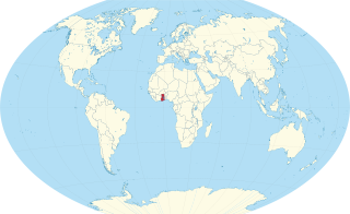
Guinea is a traditional name for the region of the coast of West Africa which lies along the Gulf of Guinea. It is a naturally moist tropical forest or savanna that stretches along the coast and borders the Sahel belt in the north.

The Tripartite Convention of 1899 concluded the Second Samoan Civil War, resulting in the formal partition of the Samoan archipelago into a German colony and a United States territory.

French Togoland was a French colonial League of Nations mandate from 1916 to 1946, and a UN trust territory from 1946 to 1960 in French West Africa. In 1960 it became the independent Togolese Republic.

Raphael Ernest Grail Armattoe was a Ghanaian scientist and political activist. He was nominated for the 1948 Nobel Peace Prize and was a campaigner for unification of British and French Togoland. He was called by the New York Post "the 'Irishman' from West Africa", and the BBC producer Henry Swanzy referred to him as the "African Paracelsus".

Osu Castle is a castle located in Osu, Ghana, on the coast of the Gulf of Guinea in Africa.
The Gold Coast was the name for a region on the Gulf of Guinea in West Africa that was rich in gold, petroleum, sweet crude oil and natural gas. This former region is now known as the country Ghana.

This is a survey of the postage stamps and postal history of Togo.
A plebiscite was held in British Togoland on 9 May 1956 to decide the status of the territory. Since World War I, the territory had been a League of Nations mandate under British control, and became a United Nations Trust Territory after World War II. The referendum offered residents the choice of remaining a Trust Territory until neighbouring French Togoland had decided upon its future, or becoming part of soon-to-be Ghana. The Ewe-based Togoland Congress campaigned against and preferred amalgamation with French Togoland.

The Togoland campaign was a French and British invasion of the German colony of Togoland in West Africa, which began the West African campaign of the First World War. German colonial forces withdrew from the capital Lomé and the coastal province to fight delaying actions on the route north to Kamina, where the Kamina Funkstation linked the government in Berlin to Togoland, the Atlantic and South America.

Western Togoland is a self-proclaimed state which is considered by the international community to be part of Ghana. It claims five of the Volta and Oti Regions. On 25 September 2020 separatists in Western Togoland declared independence from the Republic of Ghana. Western Togoland has been a member state of the Unrepresented Nations and Peoples Organization (UNPO) since 2017.

The Ewe Unification Movement was a series of west African ethno-nationalist efforts which sought the unification of the Ewe peoples spread across what are now modern Ghana and Togo. It emerged as a direct political goal around 1945 under the colonial mandate of French Togoland, however the ideal of unifying the group has been an identifiable sentiment present amongst the ethnicity's leadership and wider population ever since their initial colonial partitions by the British and German Empires from 1874 to 1884. While there have been many efforts to bring about unification, none have ultimately been successful due to both the platform itself often being a secondary concern for political leadership, or inter/intrastate conflicts overshadowing them.

The Benin–Togo border is 651 km in length and runs from the tripoint with Burkina Faso in the north down to the Bight of Benin in the south.

The Ghana–Togo border is 1,098 km in length and runs from the tripoint with Burkina Faso in the north to the Atlantic Ocean in the south.
The Political history of Ghana recounts the history of varying political systems that existed in Ghana during pre-colonial times, the colonial era and after independence. Pre-colonial Ghana was made up of several states and ethnic groups whose political system was categorized by 3 main administrative models; Centralized, Non-centralized and Theocratic states. In the colonial era, the British Empire employed different forms of government among its four territorial possessions in the Gold Coast. Indirect rule was implemented in the late 19th century after its success in Northern Nigeria. From the 1940s, native Ghanaians yearned for more autonomy. This resulted in the several constitutional reforms as well as the creation of the office of the Prime Minister in 1952.