
The Broads is a network of mostly navigable rivers and lakes in the English counties of Norfolk and Suffolk. Although the terms "Norfolk Broads" and "Suffolk Broads" are correctly used to identify specific areas within the two counties respectively, the whole area is frequently referred to as the Norfolk Broads.

Wroxham is a village and civil parish in the English county of Norfolk. The civil parish of Wroxham has an area of 6.21 square kilometres, and in 2001, had a population of 1,532 in 666 households. A reduced population of 1,502 in 653 households was noted in the 2011 Census. The village is situated within the Norfolk Broads on the south side of a loop in the middle reaches of the River Bure. It lies in an elevated position above the Bure, between Belaugh Broad to the west, and Wroxham Broad to the east and south east. Wroxham is some eight miles north-east of Norwich, to which it is linked by the A1151 road. The village and broad lie in an area of fairly intensive agriculture, with areas of wet woodland adjoining the broad and river. For the purposes of local government, the parish falls within the district of Broadland although the river, broad and their immediate environs fall within the executive area of the Broads Authority. On the northern side of the Bure is the village of Hoveton, often confused with Wroxham.

Horning is an ancient village and parish in the English county of Norfolk. It covers an area of 11 km2 and had a population of approximately 1,100 in the 2021 census. Horning parish lies on the northern bank of the River Bure south of the River Thurne and is located in The Broads National Park. For the purposes of local government, it falls within the district of North Norfolk, although areas alongside the rivers and broads fall into the executive area of the Broads Authority.

Woodbastwick is a village and civil parish in the English county of Norfolk. It is located on the River Bure between Cockshoot Broad and Salhouse Broad, within The Broads and close to Bure Marshes NNR. The city of Norwich lies 10 kilometres (6.2 mi) to the south-west.

Potter Heigham is a village and civil parish on the River Thurne in the English county of Norfolk. It is situated 12 mi (19 km) north-east of the city of Norwich on the A149 road, and within the Broads National Park.

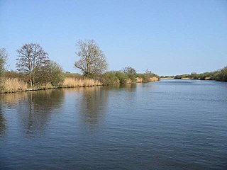
Hoveton Great Broad lies within The Broads in Norfolk, England, between Wroxham Broad and Salhouse Broad.

Salhouse is a village and civil parish in the Broads in the English county of Norfolk. It lies south of the River Bure and Salhouse Broad, about 10 kilometres (6.2 mi) north-east of Norwich. The civil parish has an area of 8.96 km2 (3.46 sq mi) and in the 2001 census had a population of 1,462 in 604 households, increasing to 1,486 in 638 households at the 2011 Census. For the purposes of local government, the parish falls within the district of Broadland although areas adjoining the river and broad fall into the executive area of the Broads Authority.

Stalham is a market town and civil parish on the River Ant in the English county of Norfolk, in East Anglia. It covers an area of 2.82 sq mi (7.3 km2) and had a population of 2,951 in 1,333 households at the 2001 census, the population increasing to 3,149 at the 2011 Census. It lies within the Norfolk Broads, about 15 miles (24 km) north-east of Norwich on the A149 road. For the purposes of local government, it falls within the district of North Norfolk. The parts of the parish lying adjacent to the river fall into the executive area of the Broads Authority.

Broadland is a local government district in Norfolk, England, named after the Norfolk Broads. Its council is based at the Broadland Business Park on the outskirts of Norwich. The district includes the towns of Acle, Aylsham, Reepham, Sprowston and Thorpe St Andrew. Several of the district's settlements form part of the Norwich built-up area, lying outside the city's boundaries to the north-west and north-east. The district also includes numerous villages and surrounding rural areas. Some eastern parts of the district lie within The Broads.

The Bittern Line is a railway branch line in Norfolk, England, that links Norwich to Sheringham. It passes through the Broads on its route to an Area of Outstanding Natural Beauty on the north Norfolk coast. It is named after the bittern, a rare bird found in the reedy wetlands of Norfolk.

Mousehold Heath is a freely accessible area of heathland and woodland which lies to the north-east of the medieval city boundary of Norwich, in the English county of Norfolk.

Hoveton & Wroxham railway station is on the Bittern Line in Norfolk, England, serving the village of Hoveton and the adjacent village of Wroxham. It is 8 miles 61 chains (14.1 km) down the line from Norwich and is situated between Salhouse and Worstead.

Salhouse railway station is on the Bittern Line in Norfolk, England, serving the village of Salhouse. It is the next station along the line from Norwich, 5 miles 74 chains (9.5 km) from that terminus; the following station is Hoveton & Wroxham. Train services are operated by Greater Anglia.

Whitlingham is a small hamlet and former civil parish at the mouth of the River Wensum, now in the parish of Kirby Bedon, in the South Norfolk district, in the county of Norfolk, England. It is located 3 miles (5 km) east of Norwich, on the south bank of the River Yare, reached from Trowse along Whitlingham Lane. In 1931 the parish had a population of 99. On 1 April 1935 the parish was abolished and merged with Kirby Bedon.

Surlingham is a village and civil parish in the South Norfolk district of Norfolk situated on the Broads in eastern United Kingdom. It lies approximately 6½ miles south-east of Norwich on the south bank of the River Yare between Bramerton and Rockland St Mary. In the 2001 census it contained 266 households and a population of 637, increasing to 725 at the 2011 census. Although Surlingham is part of South Norfolk District, as in other broadland villages those areas of the village adjacent to the river and broads fall into the executive area of the Broads Authority.

The A149 is commonly known as "The Coast Road" to local residents and tourists, as this road runs along the North Norfolk coast from King's Lynn to Great Yarmouth, via coastal villages.
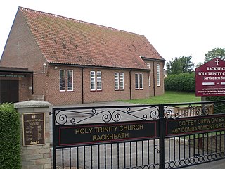
Rackheath is a village and civil parish in the English county of Norfolk, and is roughly 6 miles (9.7 km) north-east of Norwich city centre. It covers an area of 7.52 km2 (2.90 sq mi) and had a population of 1,551 in 625 households at the 2001 census, increasing to a population of 1,972 in 762 households at the 2011 Census. For the purposes of local government, it falls within the district of Broadland. It is the site of a proposed new eco-town.

Broadland High Ormiston Academy is a rural mixed academy in Hoveton, Norfolk for pupils aged 11 to 16. As of August 1, 2018, the school joined Ormiston Academies Trust.
The Rackheath Eco-town is a proposal for just over 5,000 houses to be built in the Rackheath area, in Norfolk, within a mile of The Broads National Park. The controversial proposals have been featured on many programmes, including BBC One's Politics Show, BBC One's Look East, ITV's Anglia Tonight and a BBC One Norwich North By-Election Special.
Bure Broads and Marshes is a 741.1-hectare (1,831-acre) biological Site of Special Scientific Interest north-east of Norwich in Norfolk. Most of it is a Nature Conservation Review site, Grade I and National Nature Reserve. Two areas are nature reserves managed by the Norfolk Wildlife Trust, Cockshoot Broad and Ranworth Broad. It is part of the Broadland Ramsar site and Special Protection Area and The Broads Special Area of Conservation,

