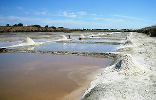
Holkham National Nature Reserve is England's largest national nature reserve (NNR). It is on the Norfolk coast between Burnham Overy Staithe and Blakeney, and is managed by Natural England with the cooperation of the Holkham Estate. Its 3,900 hectares comprise a wide range of habitats, including grazing marsh, woodland, salt marsh, sand dunes and foreshore. The reserve is part of the North Norfolk Coast Site of Special Scientific Interest, and the larger area is additionally protected through Natura 2000, Special Protection Area (SPA) and Ramsar listings, and is part of both an Area of Outstanding Natural Beauty (AONB) and a World Biosphere Reserve. Holkham NNR is important for its wintering wildfowl, especially pink-footed geese, Eurasian wigeon and brant geese, but it also has breeding waders, and attracts many migrating birds in autumn. A number of scarce invertebrates and plants can be found in the dunes, and the reserve is one of the only two sites in the UK to have an antlion colony.
The Old Salt Route was a medieval trade route in northern Germany, one of the ancient network of salt roads which were used primarily for the transport of salt and other staples. In Germany it was referred to as Alte Salzstraße.

Saltville is a town in Smyth and Washington counties in the U.S. state of Virginia. The population was 2,077 at the 2010 census. It is part of the Kingsport–Bristol (TN)–Bristol (VA) Metropolitan Statistical Area, which is a component of the Johnson City–Kingsport–Bristol, TN-VA Combined Statistical Area – commonly known as the "Tri-Cities" region.

Barletta is a city, comune of Apulia, in south eastern Italy. Barletta is the capoluogo, together with Andria and Trani, of the Province of Barletta-Andria-Trani. It has a population of around 94.700 citizens.
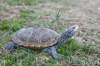
The diamondback terrapin or simply terrapin, is a species of turtle native to the brackish coastal tidal marshes of the eastern and southern United States, and in Bermuda. It belongs to the monotypic genus, Malaclemys. It has one of the largest ranges of all turtles in North America, stretching as far south as the Florida Keys and as far north as Cape Cod.
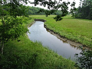
A tidal marsh is a marsh found along rivers, coasts and estuaries which floods and drains by the tidal movement of the adjacent estuary, sea or ocean. Tidal marshes experience many overlapping persistent cycles, including diurnal and semi-diurnal tides, day-night temperature fluctuations, spring-neap tides, seasonal vegetation growth and decay, upland runoff, decadal climate variations, and centennial to millennial trends in sea level and climate. They are also impacted by transient disturbances such as hurricanes, floods, storms, and upland fires.
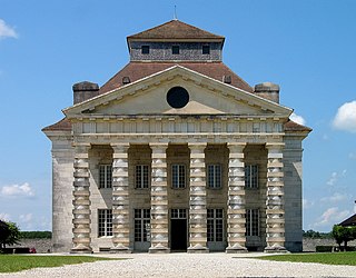
The Saline Royale is a historical building at Arc-et-Senans in the department of Doubs, eastern France. It is next to the Forest of Chaux and about 35 kilometers from Besançon. The architect was Claude-Nicolas Ledoux (1736–1806), a prominent Parisian architect of the time. The work is an important example of an early Enlightenment project in which the architect based his design on a philosophy that favored arranging buildings according to a rational geometry and a hierarchical relation between the parts of the project.

Salthouse is a village and a civil parish in the English county of Norfolk. It is situated on the salt marshes of North Norfolk. It is 3.8 miles (6.1 km) north of Holt, 5.4 miles (8.7 km) west of Sheringham and 26.3 miles (42.3 km) north of Norwich. The village is on the A149 coast road between King's Lynn and Great Yarmouth. The nearest railway station is at Sheringham for the Bittern Line which runs between Sheringham, Cromer and Norwich. The nearest airport is Norwich International Airport. The landscape around Salthouse lies within the Norfolk Coast AONB and the North Norfolk Heritage Coast. The civil parish has an area of 6.22 km2 (2.40 sq mi) and in 2001 had a population of 196 in 88 households, the population increasing to 201 at the 2011 Census. For the purposes of local government, the parish falls within the district of North Norfolk.

Havergate Island is the only island in the county of Suffolk, England. It is found at the confluence of the River Ore and the Butley River near the village of Orford. It is a marshy nature reserve run by the Royal Society for the Protection of Birds (RSPB) and is known for its population of avocets and terns. It is part of the ecologically important Alde-Ore Estuary and has protected conservation status as part of a national nature reserve, SSSI, SAC, SPA, Ramsar Site and is also a part of the Suffolk Coast and Heaths AONB.

Margherita di Savoia is a town and comune in the Province of Barletta-Andria-Trani. It was given this name in 1879 in honour of Queen Margherita of Savoy, previously it had been known as Saline di Barletta.

The nature conservation site Poda was declared a protected area in 1989 by the Bulgarian Ministry of Water and Environment. It was the first protected area in Bulgaria that is completely managed and maintained by a non-governmental organization, the Bulgarian Society for the Protection of Birds(BSPB). BSPB prepares and implements activities adopted by the Council of Minister's Management Plan, but receives its funding completely from entrance fees, souvenirs sold, and donations. Through this arrangement, it aims to be a sustainable model for nature conservation, environmental education, and eco-tourism.
The Sülze Saltworks was a 'saline', or saltworks, on the Lüneburg Heath in Germany which was worked for centuries, from the High Middle Ages to 1862. It had a considerable impact on the history of the village of Sülze and other heath villages in the area.
The Carapelle is a river in the province of Foggia in the Apulia region of Italy. The source of the river is north of Anzano di Puglia near the border with the province of Avellino in the Daunian Mountains, along the Campanian Apennine. The river flows northeast near Monteleone di Puglia before curving eastward and flowing near Accadia and Sant'Agata di Puglia before being joined by a right tributary, the Calaggio. The river then curves northeast and is joined by a left tributary, the Carapellotto, before flowing past Ordona and Carapelle. The river connects with the Saline di Margherita di Savoia salt marsh via two branches on the south bank of the river before emptying into the Gulf of Manfredonia in the Adriatic Sea northwest of Zapponeta.
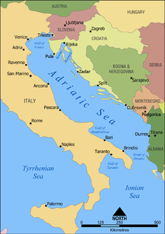
The Gulf of Manfredonia is a gulf on the east coast of Italy. It is part of the Adriatic Sea. The Monte Gargano peninsula forms the northern border of the gulf, and the Apulian coast forms the southern border. Several rivers flow into the gulf, including the Carapelle and the Cervaro. The gulf is named after the town Manfredonia. Areas along the coast include marshes such as the Saline di Margherita di Savoia.

The Gulf St Vincent Important Bird Area comprises land extending along the coast of Gulf St Vincent, north of Adelaide, South Australia.

Eden Landing Ecological Reserve is a nature reserve in Hayward and Union City, California, on the eastern shore of San Francisco Bay. The reserve is managed by the California Department of Fish and Game and comprises 5,040 acres of former industrial salt ponds now used as a low salinity waterbird habitat. It lies between the Hayward Regional Shoreline and Alameda Creek Regional Trail to the north and adjacent to Don Edwards National Wildlife Refuge and Coyote Hills Regional Park to the south and is south and adjacent to the San Mateo–Hayward Bridge, across which lies the Hayward Shoreline Interpretive Center. Some waterfowl hunting is periodically permitted. The remains of the Oliver Salt Company are located in the reserve.
Protected areas of Libya include any geographical area protected for a specific use.


