
Sequoyah County is a county located in the U.S. state of Oklahoma. As of the 2010 census, the population was 42,391. The county seat is Sallisaw. Sequoyah County was created in 1907 when Oklahoma became a state. It was named after Sequoyah, who created the Cherokee syllabary.

Sallisaw is a city and county seat of Sequoyah County. The population was 8,880 at the 2010 Census, an 11.2 percent increase from 7,891 at the 2000 census. Sallisaw is part of the Fort Smith, Arkansas–Oklahoma Metropolitan Statistical Area.

Vian is a town in Sequoyah County, Oklahoma, United States. It is part of the Fort Smith, Arkansas-Oklahoma Metropolitan Statistical Area. The population was 1,466 at the 2010 census, a 7.6 percent gain from 1,362 at the 2000 census. It was named for Big Vian and Little Vian Creeks. Nearby tourist attractions include Lake Tenkiller, Lake Robert S. Kerr and Sequoyah National Wildlife Refuge.

The Boston Mountains is a Level III ecoregion designated by the Environmental Protection Agency (EPA) in the U.S. states of Arkansas and Oklahoma. Part of the Ozark Mountains, the Boston Mountains are a deeply dissected plateau. The ecoregion is steeper than the adjacent Springfield Plateau to the north, and bordered on the south by the Arkansas Valley. The Oklahoma portion of the range is locally referred to as the Cookson Hills.
The Little Red River is a 102-mile-long (164 km) river in White, Van Buren, Searcy, Stone and Cleburne counties of north-central Arkansas.
The Cullasaja River is a short river located entirely in Macon County, North Carolina. It is a tributary of the Little Tennessee River, into which it flows near the county seat of Franklin. It originates to the southeast, near Highlands, the county's only other town. It flows from manmade Lake Sequoyah, which is fed by Mirror Lake and other creeks and streams originating on the western side of the Eastern Continental Divide, which runs through the east side of Highlands.
The Poteau River is a 141-mile (227 km) long river located in the U.S. states of Arkansas and Oklahoma. It is the only river in Oklahoma that flows north and is the seventh largest river in the state. It is a tributary of the Arkansas River, which itself is a tributary of the Mississippi River.

Rolling Fork is a 55.4-mile-long (89.2 km) river in southwest Arkansas. It is dammed by DeQueen Dam and forms DeQueen Lake. It is a tributary of the Little River, running parallel with other tributaries such as the Cossatot River, the Saline River, the Mountain Fork, and the Glover River. It is part of the Mississippi watershed.
The North Fork River or the North Fork of White River is a 109-mile-long (175 km) tributary of the White River, into which it flows near Norfork, Arkansas.

Lee Creek is a 64.6-mile-long (104.0 km) river in Arkansas and Oklahoma which starts near West Fork in Washington County, Arkansas and flows south to the Arkansas River passing through Crawford County, Arkansas and Sequoyah County, Oklahoma. Lee Creek flows from Arkansas into Oklahoma, then returns to Arkansas before its confluence with the Arkansas River near Van Buren.
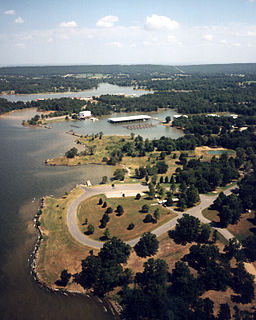
Robert S. Kerr Reservoir is located within the Cookson Hills, on the Arkansas River in Sequoyah, Le Flore, Haskell, and Muskogee counties in eastern Oklahoma, US. It is about eight miles south of the nearest major town, Sallisaw, Oklahoma. The reservoir is impounded by Robert S. Kerr Lock and Dam at river mile 336.2 on the Arkansas River, just a few miles below its confluence with the Canadian River. The lock and dam are part of the McClellan-Kerr Arkansas River Navigation System, which provides for barge navigation on the Arkansas River and some of its tributaries. The U.S. Army Corps of Engineers maintains the locks and navigation system.

The Little River is a tributary of the Red River, with a total length of 217 miles (349 km), 130 miles (210 km) in southeastern Oklahoma and 87 miles (140 km) in southwestern Arkansas. in southeastern Oklahoma and southwestern Arkansas in the United States. Via the Red, it is part of the watershed of the Mississippi River. Six large reservoirs impound the Little River and its tributaries. The drainage basin of the river totals 4,204 square miles (10,890 km2), 2,204 square miles (5,710 km2) in Oklahoma and 2,036 square miles (5,270 km2) in Arkansas. The Little River and its upper tributaries are popular for recreational canoeing and kayaking.
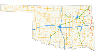
U.S. Highway 59 (US-59) heads along the eastern portion of the state of Oklahoma. US-59's 216.47-mile (348.37 km) route through Oklahoma takes it through the mountainous terrain of the eastern Oklahoma Ouachitas and Ozarks. US-59 serves several lakes and towns through Oklahoma's Green Country, including Grand Lake, a major recreation center. The route enters the state from Arkansas near Fogel, Arkansas, and ends at the Kansas state line south of Chetopa, Kansas.

Baron is an unincorporated community in rural Adair County, Oklahoma, United States, located along U.S. Route 59 between Westville and Stilwell. It was built on the West Branch of the Baron Fork of the Illinois River, a tributary of the Arkansas River via the Illinois River.
Ballenger Creek is a 10.7-mile-long (17.2 km) tributary of the Monocacy River in Frederick County, Maryland. The headwaters of the creek are located on the east slope of Catoctin Mountain, about 3 miles (5 km) west of the city of Frederick. The stream runs roughly southeast to the Monocacy National Battlefield and the confluence with the Monocacy River, which drains to the Potomac River. The watershed area of the creek is 21.8 square miles (56 km2).

Indian River is a 59.1-mile-long (95.1 km) tributary of the Manistique River on the Upper Peninsula of Michigan in the United States. It rises out of Hovey Lake at 46°17′36″N86°42′20″W on Hiawatha National Forest land in Alger County and flows south and east through a lake district and on through Schoolcraft County. The river flows into the 8,659 acre (35 km²) Indian Lake at 46°17′36″N86°42′20″W and flows out at 45°59′30″N86°17′15″W. It then flows east and south about 2.5 miles where it merges with the Manistique River, which then flows through Manistique and into Lake Michigan at 45°56′56″N86°14′45″W.
The Baron Fork of the Illinois River is a tributary of the Illinois River in the U.S. states of Arkansas and Oklahoma. The stream is sometimes called Baron Fork River, Barren Fork Creek or simply Barren Fork.
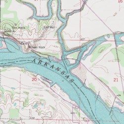
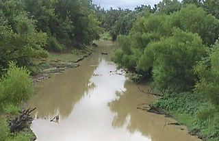
Big Skin Bayou, also known as Skin Bayou or Big Skin Creek, is a tributary of the Arkansas River located in Sequoyah County, Oklahoma. It takes its name from the French word "skein" which are loose, tangled layers of yarn. A large, colorful canebrake resembling yarn; formed a near impenetrable, natural wall near the mouth of the creek before it was cleared for farming. French trappers and explorers named several of the major tributaries of the Arkansas River in Oklahoma; as it was once a part of the French Territory of Louisiana that was later the Louisiana Purchase. At one time, there were large rock bluffs near Big Skin's confluence with the Arkansas. The bluff on the south side of the river and across from Big Skin's confluence was known as Swallow Rock, named for the birds that nested there and was the site of the old Fort Coffee. The bluff on the north side of the river and west of Big Skin is known as Wilson Rock. Both bluffs formed a natural wharf and served as historic steamboat landings and ferry crossings. The cemetery at Wilson Rock contains the graves of local residents as well as some travelers that fell victim to the river over the years. Tiana, the wife of the famed Texan Sam Houston was buried at Wilson Rock Cemetery for several years until she was moved to a cemetery near Fort Gibson. Wilson Rock and Big Skin Bayou were also drop off points for several groups of Cherokees that were forced to relocate to that part of Oklahoma/Indian Territory on the Trail of Tears. The relocated tribesmen that disembarked here would then follow the creek into the interior parts of Skin Bayou District where they settled. Most of eastern Sequoyah County was included in the "Skin Bayou District" of Cherokee Nation, Indian Territory; which also took its name from the creek.
Brushy Creek Reservoir, now known as Brushy Lake, is a reservoir located eight miles northeast of Sallisaw, Oklahoma on a tributary of Sallisaw Creek. Brushy Lake Park is located around the reservoir. Formerly known as Brushy Lake Reservoir and State Park, the area is now owned and operated by the city of Sallisaw.

Hickory Creek is a stream in southern Benton County, Arkansas in the United States. It is a tributary of the White River within Beaver Lake.


