Related Research Articles

The Stickeen Territories, also colloquially rendered as Stickeen Territory,Stikine Territory, and Stikeen Territory, was a territory of British North America whose brief existence began July 19, 1862, and concluded July of the following year. The region was split from the North-Western Territory in the wake of the Stikine Gold Rush. The initial strike attracted large numbers of miners — mostly American — to the region; by detaching the region from the exclusive trade zone of the Hudson's Bay Company, British authorities were able to impose tariffs and licences on the speculators. The new territory, named after the Stikine River, was under the responsibility of the Governor of the Colony of British Columbia, James Douglas, who was appointed "Administrator of the Stickeen Territories" and under British law, within the jurisdiction of the Supreme Court of British Columbia.
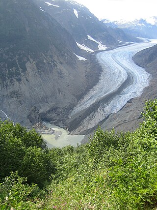
The Salmon River is a braided stream that flows through Hyder, Alaska, and empties into the Portland Canal. It is fed by meltwater from the Salmon Glacier, which is located within British Columbia approximately 13 miles north of its confluence into the Canal and is road-accessible from the town of Stewart, British Columbia. The river crosses the Canada–United States border at 56°02′00″N130°02′00″W.

Princess Royal Island is the largest island on the North Coast of British Columbia, Canada. It is located amongst the isolated inlets and islands east of Hecate Strait on the British Columbia Coast. At 2,251 square kilometres (869 sq mi), it is the fourth largest island in British Columbia. It was named in 1788 by Captain Charles Duncan, after his ship Princess Royal.
Banana Island Provincial Park is a provincial park in British Columbia, Canada. It is a small 10.4 hectare island in the South Thompson River, located approximately 35 kilometres east of Kamloops. There are no camping or recreational facilities, as it is an environmentally sensitive area. The island was designated as a provincial park on 30 April 1996 following recommendations from the Kamloops Land and Resource Management Plan to protect spring salmon spawning grounds and nesting grounds for several varieties of birds. It is used for nesting by Canada geese, Osprey and bald eagles, and other waterfowl and raptors. It is also a winter habitat for Tundra and Trumpeter swans. The island is vegetated with ponderosa pine and grassy undercover, and was historically used by the Neskonlith First Nation in accessing river resources.
Momich Lakes Provincial Park is a provincial park in British Columbia, Canada, located at the north end of Adams Lake 100 km northeast of Kamloops.

Stamp River Provincial Park is a provincial park in British Columbia, Canada. The 327-hectare park is located 14 km north of Port Alberni on Vancouver Island. There are 23 camping spaces and 2 km of trails within the park along the Stamp River, named for Edward Stamp, a sawmill pioneer in the Alberni Valley.

The Moat House is a Grade II* building in Tamworth, Staffordshire, England, in what were once the grounds of Tamworth Castle. The summer house, in the rear beer garden, is a Grade II listed building.
The Stikine Ranges are a group of mountain ranges and mountainous plateaus in northwestern British Columbia, Canada. They are the northernmost subdivision of the Cassiar Mountains and among the least explored and most undeveloped parts of the province.

Namu is a small fishing port, former cannery town and First Nations community on the coast of British Columbia, Canada. It is located about 95 km (59.0 mi) southwest of Bella Coola or 35 km (21.7 mi) SSE of Bella Bella, on the mainland shore of the Inside Passage ferry route directly opposite Hunter Island, and just south of the opening of Burke Channel and King Island. The community's harbour is named Namu Harbour, and a large lake just inland is Namu Lake, which lies in the short drainage basin of the 15 km Namu River, immediately east of which is the small but rugged Namu Range.
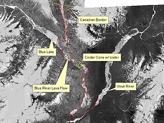
The Unuk River is a river in the U.S. state of Alaska and the Canadian province of British Columbia. It flows from the Coast Mountains southwest to Behm Canal, northeast of Ketchikan, Alaska.
The Tahltan First Nation, also known as the Tahltan Indian Band, is a band government of the Tahltan people. Their main community and reserves are located at Telegraph Creek, British Columbia. Their language is the Tahltan language, which is an Athabaskan language also known as Nahanni, is closely related to Kaska and Dunneza. Their Indian and Northern Affairs Canada band number is 682. The Tahltan First Nation is joined with the Iskut First Nation in a combined tribal council-type organization known as the Tahltan Nation.
Juan Perez Sound is a sound off the east coast of Moresby Island in the Queen Charlotte Islands of British Columbia, Canada. It is named for Juan José Pérez Hernández, usually known as Juan Pérez, who was among the first European explorers in the region.
Pekwuteu is a former Yurok settlement in Humboldt County, California. It was located on the Lower Klamath River opposite town of Weitchpec, at an elevation of 348 feet.
The Taku River Tlingit First Nation are the band government of the Inland Tlingit in far northern British Columbia, Canada and also in Yukon. They comprise two ḵwaan (tribes) of the Tlingit people, who are otherwise coastal, the Áa Tlein Ḵwáan of the Atlin Lake area and the Deisleen Ḵwáan of Teslin Lake, whose main focus is the Teslin Tlingit Council in Teslin, Yukon. Their band offices are in Atlin, British Columbia.
The Stikine Gold Rush was a minor but important gold rush in the Stikine Country of northwestern British Columbia, Canada. The rush's discoverer was Alexander "Buck" Choquette, who staked a claim at Choquette Bar in 1861, just downstream from the confluence of the Stikine and Anuk Rivers, at approximately 56°48′N131°46′W. Choquette was the son-in-law of the Tlingit chief Chief Shakes, who presided over the region at the mouth of the river, the site of the former Fort Stikine and today's city of Wrangell, Alaska, and had also explored the Nass and several other rivers.
Oregana Creek Provincial Park is a provincial park in British Columbia, Canada, located 150 kilometres northwest of Salmon Arm, British Columbia, near Adams River. The park, which is 286 ha. in size, was established in 2010.
The Tlell River is a watercourse on the east side of Graham Island in Haida Gwaii, British Columbia, Canada. It enters Hecate Strait near the community of Tlell. It is the second-longest river in Haida Gwaii, after the Yakoun. Its lower reaches are within Naikoon Provincial Park. The Tlell's headwaters and the swamps of its upper reaches are protected within the Tlall Conservancy. The river is popular with anglers, as it supports large coho salmon.
Salmon House Falls is a waterfall at the confluence of the Takia and Dean Rivers at the western edge of the Interior Plateau, northwest of Tsitsutl Peak.
The Takia River is a tributary of the Dean River in British Columbia, Canada, flowing northwest to meet the Dean to the south of Sigutlat Lake. Salmon House Falls is located at the confluence of the two rivers, which is to the northwest of Tsitsutl Peak.