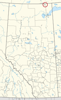
Fort Chipewyan, commonly referred to as Fort Chip, is a hamlet in northern Alberta, Canada, within the Regional Municipality (RM) of Wood Buffalo. It is located on the western tip of Lake Athabasca, adjacent to Wood Buffalo National Park, approximately 223 kilometres (139 mi) north of Fort McMurray.

Wood Buffalo National Park is the largest National Park of Canada at 44,807 km2 (17,300 sq mi). It is located in northeastern Alberta and the southern Northwest Territories. Larger in area than Switzerland, it is the second-largest national park in the world. The park was established in 1922 to protect the world's largest herd of free roaming wood bison, currently estimated at more than 5,000. It is one of two known nesting sites of whooping cranes.

The Liard River of the North American boreal forest flows through Yukon, British Columbia and the Northwest Territories, Canada. Rising in the Saint Cyr Range of the Pelly Mountains in southeastern Yukon, it flows 1,115 kilometres (693 mi) southeast through British Columbia, marking the northern end of the Rocky Mountains and then curving northeast back into Yukon and Northwest Territories, draining into the Mackenzie River at Fort Simpson, Northwest Territories. The river drains approximately 277,100 square kilometres (107,000 sq mi) of boreal forest and muskeg.

Fort Smith is a town in the South Slave Region of the Northwest Territories (NWT), Canada. It is located in the southeastern portion of the Northwest Territories, on the Slave River and adjacent to the Northwest Territories/Alberta border.

Division No. 16 is a census division in Alberta, Canada. It is located in the northeast portion of northern Alberta and surrounds the Urban Service Area of Fort McMurray.
There are several lakes named Mud Lake within the Canadian province of Alberta.

Northern Alberta is a region located in the Canadian province of Alberta.

Fitzgerald, also known as Fort Fitzgerald and originally Smith's Landing, is an unincorporated community in northern Alberta within the Regional Municipality of Wood Buffalo, located 15.4 kilometres (9.6 mi) south of the Northwest Territories border, and 23 kilometres (14 mi) southeast of Fort Smith.

Saprae Creek is a hamlet in northern Alberta, Canada within the Regional Municipality (R.M.) of Wood Buffalo. It is located 3 kilometres (1.9 mi) north of Highway 69, approximately 11 kilometres (6.8 mi) east of Fort McMurray.

Peace Point 222 is an Indian reserve of the Mikisew Cree First Nation in Alberta, located within Improvement District No. 24.

Waterways is a locality within the Regional Municipality of Wood Buffalo in northern Alberta, Canada. It is now a neighbourhood within the Fort McMurray urban service area along the west bank of the Clearwater River, south of the river's confluence with the Athabasca River.

The Northern Journal is a weekly newspaper based out of Fort Smith, Northwest Territories, Canada. As of 2013, the Northern Journal provides coverage of events in the Northwest Territories, alongside NWT News/North. It also covers the Municipality of Wood Buffalo in northeastern Alberta, including Fort Chipewyan, Fort McMurray and the oilsands industry. Up until January 2011, the Northern Journal was operated as the Slave River Journal, until owner Don Jaque made the decision to extend the scope of his publication to include the entirety of the Northwest Territories. The Northern Journal had a stated circulation of 4,000, as of June 2013. In addition to resident journalists, Northern Journal draws from a number of freelance writers and photographers across the NWT including regular contributors in Yellowknife.

ʔejëre K’elnı Kuę́ 196I, also known as Hay Camp, is an Indian reserve in northern Alberta, Canada. The reserve is one of ten reserves under the governance of the Smith's Landing First Nation, known in their language as the Dene Ch'anie. The reserve is located on the west bank of Slave River within Wood Buffalo National Park, and comprises 213 ha.

Namur Lake 174B is an Indian reserve of the Fort McKay First Nation in Alberta, located within the Regional Municipality of Wood Buffalo. It is 105 kilometres northwest of Fort McMurray.

Namur River 174A is an Indian reserve of the Fort McKay First Nation in Alberta, located within the Regional Municipality of Wood Buffalo. It is 65 kilometres northwest of Fort McMurray.

Tthebacha Náre 196, also known as Border Town, is an Indian reserve of the Smith's Landing First Nation in Alberta, located within the Regional Municipality of Wood Buffalo. In the 2016 Canadian Census, it recorded a population of 28 living in 8 of its 16 total private dwellings.

Łı̨ Dezé 196C is an Indian reserve of the Smith's Landing First Nation in Alberta, located within the Regional Municipality of Wood Buffalo.

Ts’u Nedhé 196H is an Indian reserve of the Smith's Landing First Nation in Alberta, located within Improvement District No. 24.

Tthejëre Ghaı̨lı̨ 196B, also known as Salt River, is an Indian reserve of the Smith's Landing First Nation in Alberta, located within the Regional Municipality of Wood Buffalo.


