Saltdal Fjord

Last updated
Saltdal Fjord
Saltdalsfjorden  (Norwegian)
Saltdalsfjorden seen from E6.jpg
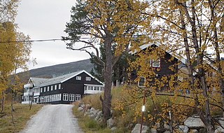
Saltdal Fjord seen from the east side looking south. European route E6 runs along the fjord at left. Parts of Rognan and the Rognan shoreline, where boat building has taken place for a long time, [1] lie slightly left of center.
Norway Nordland location map.svg
Red pog.svg
Saltdal Fjord
Location of the fjord
Relief Map of Norway.png
Red pog.svg
Saltdal Fjord
Saltdal Fjord (Norway)
Location Nordland county, Norway
Coordinates 67°07′57″N15°23′51″E / 67.1324°N 15.3976°E / 67.1324; 15.3976 Coordinates: 67°07′57″N15°23′51″E / 67.1324°N 15.3976°E / 67.1324; 15.3976
Type Fjord
Basin  countries Norway
Max. length11 kilometres (6.8 mi)
Max. width3 kilometres (1.9 mi)
Settlements Rognan

Saltdal Fjord [2] [3] [4] [5] (Norwegian : Saltdalsfjorden) is a fjord arm of Skjerstad Fjord in the municipality of Saltdal in Nordland county, Norway. The fjord extends 11 kilometers (6.8 mi) south to the village of Rognan at the bottom of the fjord.

Norwegian language North Germanic language spoken in Norway

Norwegian is a North Germanic language spoken mainly in Norway, where it is the official language. Along with Swedish and Danish, Norwegian forms a dialect continuum of more or less mutually intelligible local and regional varieties, and some Norwegian and Swedish dialects, in particular, are very close. These Scandinavian languages, together with Faroese and Icelandic as well as some extinct languages, constitute the North Germanic languages. Faroese and Icelandic are hardly mutually intelligible with Norwegian in their spoken form because continental Scandinavian has diverged from them. While the two Germanic languages with the greatest numbers of speakers, English and German, have close similarities with Norwegian, neither is mutually intelligible with it. Norwegian is a descendant of Old Norse, the common language of the Germanic peoples living in Scandinavia during the Viking Era.

Saltdal Municipality in Nordland, Norway

Saltdal is a municipality in Nordland county, Norway. It is part of the traditional district of Salten. The administrative centre of the municipality is the village of Rognan. Other villages in Saltdal include Røkland and Lønsdal.

Nordland County (fylke) of Norway

Nordland is a county in Norway in the Northern Norway region, bordering Troms in the north, Trøndelag in the south, Norrbotten County in Sweden to the east, Västerbotten County to the southeast, and the Atlantic Ocean to the west. The county was formerly known as Nordlandene amt. The county administration is in Bodø. The remote Arctic island of Jan Mayen has been administered from Nordland since 1995.

The inlet of the fjord lies between Hjelbunes, a headland to the west, and Langruodden, a promontory to the east. The village of Setså lies on the east side of the fjord, slightly inland from the shore. [6] On the west lies the hamlet of Vik inside the bay formed by Tangodden, a peninsula jutting north into the fjord. [7] Rognan lies at the foot of the fjord, [1] [8] and this is also where the Saltdal River flows into the fjord. West of the river's mouth lie the hamlets of Saksenvik and Botn. [8]

Saksenvik Hamlet in Northern Norway, Norway

Saksenvik is a basic statistical unit in the Nedre Saltdal subarea of the municipality of Saltdal in Nordland county, Norway. European route E6 passes through Saksenvik, part of the way via the Saksenvik Tunnel. Since 2012, the Saksenvik Hydroelectric Power Station has produced electricity in the region.

The Nordland Line railway and the European route E6 highway both run along the entire east side of the fjord, [8] and Norwegian County Road 515 runs along the west side.

Nordland Line railway line in Norway

The Nordland Line is a 729-kilometer (453 mi) railway line between Trondheim and Bodø, Norway. It is the longest in Norway and lacks electrification. The route runs through the counties of Trøndelag and Nordland, carrying a combination of commuter, long-haul passenger and freight trains. From Trondheim Central Station to Steinkjer Station the line is most heavily used, with hourly services by the Trøndelag Commuter Rail. There are three branch lines—the Stavne–Leangen Line at Leangen Station, the Meråker Line at Hell Station and the Namsos Line at Grong Station.

European route E6 highway in Sweden and Norway

European route E6 is the main north-south road through Norway, and the west coast of Sweden. It is 3 088 km long and runs from the southern tip of Sweden at Trelleborg, into Norway and through almost all of the country north to the Arctic Circle and Nordkapp. The route ends in Kirkenes close to the Russian border.

Related Research Articles

Rognan Village in Northern Norway, Norway

Rognan is a village and the administrative centre of the municipality of Saltdal in Nordland county, Norway. The village is located at the innermost part of Skjerstad Fjord, called Saltdal Fjord. It is located about 15 kilometres (9.3 mi) north of the village of Røkland.

Røkland Village in Northern Norway, Norway

Røkland is a village in the municipality of Saltdal in Nordland county, Norway. The village is located along the Saltdalselva river about 15 kilometres (9.3 mi) south of the municipal centre of Rognan. European route E06 and the Nordland Line both pass through the village. Røkland Station is a train station along the Nordland Line.

Lønsdal Village in Northern Norway, Norway

Lønsdal is a village in the municipality of Saltdal in Nordland county, Norway. The village is located in the Lønsdal valley, along the Lønselva river. European route E06 highway and the Nordland Line both pass through the village. The village also has a train station on the Nordland Line, about halfway between Dunderland Station and Røkland Station.

Nygårdsjøen Village in Northern Norway, Norway

Nygårdsjøen is a village area in the municipality of Gildeskål in Nordland county, Norway. Nygårdsjøen is located in the northern part of the municipality, close to the border with Bodø Municipality. The village lies along Norwegian County Road 17 on the east side of the Nordfjorden, just north of the entrance to the Beiar Fjord. Saura Church is located along the fjord on the west side of the village.

Saltfjellet mountain range in Nordland, Norway

Saltfjellet is a mountain area in Nordland county, Norway that separates the two regions of Helgeland and Salten. It is also a cultural border between the Southern and Central parts of Sápmi.

Norddalsfjorden fjord in Sunnmøre, Norway

Norddalsfjorden is a branch off of the main Storfjorden in Møre og Romsdal county, Norway. The fjord is located in Norddal Municipality and a small part is also in Stranda Municipality. The fjord is 16 kilometres (9.9 mi) long, when you include the Tafjorden arm that stretches further east, it is 24 kilometres (15 mi) in total. In the Middle Ages, the combined Norddalsfjorden and Tafjorden were probably called «Todarfjorden» (Tafjorden). Norwegian County Road 63 and Norwegian County Road 650 runs along the fjord and includes a ferry crossing between Eidsdal and Linge. In the 1960s villages Stranda-Liabygda-Eidsdal-Valldal-Norddal-Fjørå-Tafjord were still connected by a web of ferry crossings.

Skjerstad Fjord fjord in Nordland county, Norway

Skjerstad Fjord is a fjord in the municipalities of Bodø, Fauske, and Saltdal in Nordland county, Norway. It is a 40-kilometre (25 mi) long arm off of the main Saltfjorden. It is connected to the Saltfjorden by the narrow Saltstraumen strait, which has very strong tidal currents. The villages of Valnesfjord and Rognan and the town of Fauske lie along the shores of the fjord. European route E06 runs along the eastern shore of the fjord, and the Nordland Line follows the eastern and northern shores of the fjord. The Misværfjorden branches off this fjord to the south at the village of Skjerstad.

Skipsfjorden, Dønna fjord in Dønna, Norway

Skipsfjorden is an arm of the Stifjorden in Dønna Municipality in Nordland county, Norway. The 5.5-kilometre (3.4 mi) long fjord lies between the island of Dønna on the west and the island of Løkta in the east.

Valen, Bindal fjord arm in Norway

Valen is an arm of the Kjelda fjord in Bindal municipality in Nordland in Norway. It gets its name from a hamlet of the same name which lies at its south-eastern end.

Hellfjorden (Vesterålen) fjord in Vesterålen, Norway

Hellfjorden is a fjord in Nordland county, Norway. The 6.5-kilometre (4.0 mi) long fjord is an arm off of the main Eidsfjorden and the border between Sortland Municipality and Bø Municipality runs right down the middle of the fjord. The narrow fjord cuts into the large island of Langøya in the Vesterålen archipelago. The fjord lies in a very rugged, sparsely populated area.

Rognan Airport airport in Saltdal, Norway

Rognan Airport is a private airport situated in the village of Rognan in the municipality of Saltdal in Nordland county, Norway. The municipal airport features a 735-meter (2,411 ft) grass runway aligned 01/19. It is used for recreational flying and is operated by Saltdal Flyklubb.

Actions in Nordland

The Actions in Nordland were part of the Norwegian Campaign of World War II. They were a subsidiary part of the Allied attempt to recapture Narvik.

Blood Road

The Blood Road is a route northeast of Rognan in the municipality of Saltdal in Nordland county, Norway that was built by prisoners during the Second World War. The route was a new section of Norwegian National Road 50 between Rognan and Langset on the east side of Saltdal Fjord (Saltdalsfjorden), where there was a ferry service before the war. The specific incident that gave the road its name was a cross of blood that was painted on a rock cutting in June 1943. The blood came from a prisoner that was shot along the route, and the cross was painted by his brother.

Langset (Saltdal) Village in Northern Norway, Norway

Langset is a basic statistical unit in the sub-area of Nedre Saltdal in the municipality of Saltdal in Nordland county, Norway. The area is located north of Rognan and Saksenvik and south of Setså on the east side of Saltdal Fjord (Saltdalsfjorden). European route E6 and the Nordland Line pass through the area.

Blood Road Museum

The Blood Road Museum is a museum in Saltdal in Nordland county, Norway. The museum is located about 2 kilometers (1.2 mi) north of the center of Rognan and stands in the yard of the Saltdal Museum, which is part of the Nordland Museum.

Jørnfjorden

Jørnfjorden is a fjord in Bø Municipality in Nordland county, Norway. The 7-kilometre (4.3 mi) long fjord is an arm of Eidsfjorden, cutting into the large island of Langøya in the Vesterålen archipelago. The inlet to the ford lies between the villages of Straumsnes to the west and Guvåg to the east. The fjord extends 7 kilometers (4.3 mi) north to the village of Verhalsen. The fjord reaches a depth of 67 metres (220 ft) just northeast of the small village of Auvåg.

Skjerstad (municipality) Former municipality in Nordland, Norway

Skjerstad is a former municipality in Nordland county, Norway. The 465-square-kilometre (180 sq mi) municipality existed from 1838 until its dissolution in 2005. The municipality generally encompassed the area around the Misværfjorden in what is now Bodø Municipality, although it originally was much larger, also including the entire present-day Fauske Municipality. The administrative centre of Skjerstad municipality was the village of Misvær.

References

  1. 1 2 Douglas, John. 1972. The Arctic Highway: A Road and Its Setting. Newton Abbot: David and Charles, p. 45.
  2. Fitzgerald, Desmond J. L. 1949. History of the Irish Guards in the Second World War. Aldershot, UK: Gale & Polden, p. 54.
  3. Zetlitz Sømme, Axel Christian. 1949. Jordbrukets geografi i Norge, part 2. Bergen: J.W. Eide, p. 398.
  4. Buckley, Christopher. 1977. Norway: The Commandos. Dieppe. London: H.M. Stationery Office, p. 142.
  5. Plant, Terry. 1990. Nordic Journeys. Newton Abbot; Author, p. 123.
  6. Andrews, John T. 1974. Glacial Isostasy. Stroudsburg, PA: Dowden, Hutchinson & Ross, p. 226.
  7. Norges land og folk: Nordlands amt. 1908. Oslo: H. Aschehoug & Company, p. 250.
  8. 1 2 3 Philpott, Don. 1991. Visitor's Guide: Norway. Ashbourne: Moorland, p. 200.