Saltfleet Township

Last updated
An 1818 map with the location of Saltfleet Township highlighted. SaltfleetTownshipLocatorMap1818.jpeg
An 1818 map with the location of Saltfleet Township highlighted.

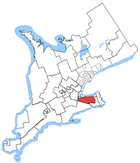
Saltfleet Township is a geographic township in Hamilton, Ontario, Canada, [1] [2] on the south shore of Lake Ontario.

The term township, in Canada, is generally the district or area associated with a town. The specific use of the term to describe political subdivisions has varied by country, usually to describe a local rural or semirural government within the country itself.

Hamilton, Ontario City in Ontario, Canada

Hamilton is a port city in the Canadian province of Ontario. An industrialized city in the Golden Horseshoe at the west end of Lake Ontario, Hamilton has a population of 536,917, and its metropolitan area, which includes Burlington and Grimsby, has a population of 747,545. The city is about 40 miles (64 km) southwest of Toronto, with which the Greater Toronto and Hamilton Area (GTHA) is formed.

Ontario Province of Canada

Ontario is one of the 13 provinces and territories of Canada. Located in Central Canada, it is Canada's most populous province accounting for 38.3 percent of the country's population, and is the second-largest province in total area. Ontario is fourth-largest jurisdiction in total area when the territories of the Northwest Territories and Nunavut are included. It is home to the nation's capital city, Ottawa, and the nation's most populous city, Toronto, which is also Ontario's provincial capital.

The township was established originally in the then Upper Canada. In 1974, it was amalgamated with the village of Stoney Creek to form the town of Stoney Creek. [3] Stoney Creek itself was amalgamated with the City of Hamilton in 2001.

Upper Canada 19th century British colony in present-day Ontario

The Province of Upper Canada was a part of British Canada established in 1791 by the Kingdom of Great Britain, to govern the central third of the lands in British North America, formerly part of the Province of Quebec since 1763. Upper Canada included all of modern-day Southern Ontario and all those areas of Northern Ontario in the Pays d'en Haut which had formed part of New France, essentially the watersheds of the Ottawa River or Lakes Huron and Superior, excluding any lands within the watershed of Hudson Bay. The "upper" prefix in the name reflects its geographic position along the Great Lakes, mostly above the headwaters of the Saint Lawrence River, contrasted with Lower Canada to the northeast.

Stoney Creek, Ontario Community/former city in Ontario, Canada

Stoney Creek is a community in the city of Hamilton in the Canadian province of Ontario. It was officially a city since 1984 until 2001 when it was amalgamated with the rest of the cities of the Regional Municipality of Hamilton-Wentworth.

See also

Related Research Articles

Ancaster—Dundas—Flamborough—Westdale federal electoral district in Ontario

Ancaster—Dundas—Flamborough—Westdale was a federal electoral district in Ontario, Canada, that has been represented in the House of Commons of Canada from 2004 until the electoral boundaries were redrawn for the 2015 election.

Wentworth County, area 269,057 acres (1,089 km2), is a historic county in the Canadian province of Ontario.

Waterdown, Ontario Dissolved municipality in Ontario, Canada

Waterdown is a community in Canada which since 2001 has been a community of Hamilton, Ontario. Waterdown is approximately 60 km west of downtown Toronto.

Bramalea, Ontario Dissolved municipality in Ontario, Canada

Bramalea (Bram-uh-lee) is a neighbourhood in the City of Brampton, Ontario, Canada. Bramalea was created as an innovative "new town", and developed as a separate community from the city. Located in the former Chinguacousy Township, it was Canada's first satellite community developed by one of the country's largest real estate developers, Bramalea Consolidated Developments, formerly known as Brampton Leasing.

Glanbrook, Hamilton, Ontario

Glanbrook is the south-western district of the city of Hamilton, Ontario, Canada. It was first created as an independent township in 1974 through the amalgamation of Mount Hope, Binbrook, Glanford, and other nearby communities. In 2001, Glanbrook became a dissolved municipality after it was amalgamated with Hamilton, Stoney Creek, Dundas, Ancaster and Flamborough to become the present city of Hamilton.

E. D. Smith Canadian politician

Ernest D'Israeli Smith was a Canadian businessman and politician who founded a food company that bears his name.

Hamilton Mountain Federal electoral district

Hamilton Mountain is a federal electoral district in Ontario, Canada, that has been represented in the House of Commons of Canada since 1968. The riding is located in the Hamilton, Ontario region.

Hamilton East—Stoney Creek Federal electoral district

Hamilton East—Stoney Creek is a federal electoral district in Ontario, Canada, that has been represented in the House of Commons of Canada since 2004.

Niagara West—Glanbrook

Niagara West—Glanbrook was a federal electoral district in Ontario, Canada, that existed from 2004 to 2015.

Stoney Creek was an electoral district in Ontario, Canada, that was represented in the House of Commons of Canada from 1997 to 2003 and in the legislative Assembly of Ontario from 1999 to 2007. It was located in the Hamilton area of Southern Ontario. This riding was created in 1996 from parts of Hamilton—Wentworth and Lincoln ridings.

Winona is a small community in southern Ontario, that is officially a part of the city of Hamilton, Ontario. It is roughly halfway between Buffalo and Toronto along the QEW.

Eastgate Square

Eastgate Square is an indoor shopping mall in Stoney Creek, Hamilton, Ontario, Canada. The mall is bounded by Queenston Road (South), Centennial Parkway (East), Delawana Drive (North) and Kenora Avenue (West).

Joseph Brant Hospital is a hospital in Burlington, Ontario.

Augustus Jones Upper Canadian Surveyor

Augustus Jones was an American-born Upper Canadian farmer, land speculator, magistrate, militia captain and surveyor. Jones trained as a surveyor in New York City, and fled as a United Empire Loyalist to Upper Canada. In Upper Canada, he worked as a crown surveyor in the Nassau District, where he quickly rose to the position of Deputy Surveyor General, the highest position in a district of Upper Canada. He occupied that position from 1789 informally, and 1791 formally, until his retirement in 1799. During that time he laid down many of the township boundaries in the Niagara Peninsula and on the north shore of Lake Ontario. He led various teams that cut many of the first sideroads and concession roads into these areas, facilitating their settlement by European and American immigrants. Jones also surveyed the routes for Dundas Street and Yonge Street, and supervised their construction. After his retirement, Jones farmed first in Saltfleet Township, later moving to Brantford and finally an estate outside Paris named Cold Springs, where he died in 1836.

Billy Green Falls is a 17-metre-high (56 ft) complex ribbon waterfall found in Battlefield Creek, Stoney Creek, Hamilton, Ontario, Canada.

West of Fifty Lower Falls is a 5.5-metre-high (18 ft) twin classic waterfall found on private property,, in Stoney Creek, Hamilton, Ontario, Canada. Named after Fifty Road in Stoney Creek.

West of Fifty Upper Cascade is a 9-metre-high (30 ft) terraced ribbon cascade waterfall found in Stoney Creek, Hamilton, Ontario, Canada. Named after Fifty Road in Stoney Creek.

Battlefield House (Stoney Creek)

Battlefield House near King Street East and Centennial Parkway in Stoney Creek, Hamilton, Ontario, Canada is a living history museum and site of the historic Battle of Stoney Creek on June 6, 1813, which was fought during the War of 1812. It was built in 1796. The house and 15.5 acres (6.3 ha) of parkland, were the property of the Women's Wentworth Historical Society, (1899-1962), and given by this society to the Niagara Parks Commission on January 19, 1962. The park was designated a National Historic Site of Canada in 1960.

Hamilton East—Stoney Creek (provincial electoral district) provincial electoral distric in Canada

Hamilton East—Stoney Creek is a provincial electoral district in Ontario, Canada, that has been represented in the Legislative Assembly of Ontario since the 2007 provincial election.

References

  1. "Saltfleet". Geographical Names Data Base. Natural Resources Canada . Retrieved 2017-11-11.
  2. "Township of Saltfleet". Canadian County Atlas Project. McGill University. 2001. Retrieved 2017-11-11.
  3. "Stoney Creek". City of Hamilton, Ontario. 2007. Archived from the original on 2007-10-31. Retrieved 2008-04-08.

Coordinates: 43°12′00″N79°43′03″W / 43.20000°N 79.71750°W / 43.20000; -79.71750

Geographic coordinate system Coordinate system

A geographic coordinate system is a coordinate system that enables every location on Earth to be specified by a set of numbers, letters or symbols. The coordinates are often chosen such that one of the numbers represents a vertical position and two or three of the numbers represent a horizontal position; alternatively, a geographic position may be expressed in a combined three-dimensional Cartesian vector. A common choice of coordinates is latitude, longitude and elevation. To specify a location on a plane requires a map projection.