The purpose of the Salton Sea Authority is to work with California state agencies, federal agencies, and Mexico to develop programs that would continue beneficial use of the Salton Sea. The Authority defines "beneficial use" to include the primary purpose of the Sea as a depository for agricultural drainage, storm water and wastewater flows; as well as for protection of endangered species, fisheries and waterfowl; and for recreational purposes.[1] In 2006, the Authority issued a multi-purpose plan for the restoration of the Sea.[2]
Projects
Habitat Creation and Enhancement: Geotube technology and solar PV power on Salton Sea Playa, Torres Martinez Wetlands
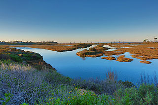
The ponds and wetlands surrounding the main body of the Salton Sea have deteriorated or evaporated over time, contributing to the decline of wildlife and native species. This project, proposed in the 2012/2013 fiscal year, will attempt to restore some of these evaporated ponds and wetlands, located in the northern areas of the Sea, using GeoTube technology to implement new berms along the edges of these ponds and wetlands. The project area consists of eleven existing ponds, nine of which are located in the Torres Martinez wetlands, and 20 acres of proposed new habitat.[3]
GeoTubes are large synthetic sandbags that are laid along the edges of a body of water or seafront to create new or support deteriorated levees or berms.[4] The size of these tubes can reach up to many feet in diameter. These GeoTubes will create the outer walls necessary to contain the water located within these new ponds and wetlands. This project will rely on the use of solar panels, or solar PV power, to pump the continuing flow of water that is needed to feed these restored ponds and wetlands. The water source for these ponds will be from a combination of a local aquifer and Colorado River water.[3]
This project will be monitored to track the amount of time rehabilitation of the natural habitat takes to re-enter and flourish to provide an example for future related projects.[3]
Restoration of Red Hill Bay on the Salton Sea, California
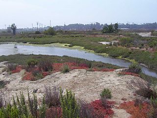
The Red Hill Bay's project goal, proposed in the 2012/2013 fiscal year, is to restore and fill the currently exposed playa located in the southern area of the Salton Sea which spans over 650 acres. This project will first establish two pumping systems to feed water back into the bay allowing migratory birds to once again utilize the habitat. The project will then implement the use of berm technology on the eastern side and the western entrance of the bay, ensuring proper containment of the newly fed water.[3] This newly pumped water will come from two sources, the Alamo River and the current salinated water of the Sea. This mixing of the two types of water will dilute the Sea's salinization levels to create a mixture capable of stabilizing and restoring the bay's natural habitat.[5]
The Red Hill Bay project will be used as an example to monitor the amount of time it takes for wildlife and fish to re-establish themselves back into this natural habitat in order to predict the ecological success for future potential Salton Sea restoration projects.[3]As of 2021[update], the project area remains flat, dry and dusty with budget issues and local politics delaying the work.[6]
The Salton Sea is a shallow, landlocked, highly saline body of water in Riverside and Imperial counties at the southern end of the U.S. state of California. It lies on the San Andreas Fault within the Salton Trough, which stretches to the Gulf of California in Mexico.
The All-American Canal is an 82-mile (132 km) long aqueduct, located in southeastern California. It conveys water from the Colorado River into the Yuma Project, the Imperial Valley, and to nine cities. It is the Imperial Valley's only water source, and replaced the Alamo Canal, which was located mostly in Mexico. The Imperial Dam, about 30 miles (48 km) northeast of Yuma, Arizona on the Colorado River, diverts water into the All-American Canal, which runs to just west of Calexico, California before its last branch heads mostly north into the Imperial Valley. Smaller canals branching off the All-American Canal move water into the Yuma Valley and the Imperial Valley. These canal systems irrigate up to 630,000 acres (250,000 ha) of crop land and have made possible a greatly increased crop yield in this area, originally one of the driest on earth. It is the largest irrigation canal in the world, carrying a maximum of 26,155 cubic feet per second (740.6 m3/s). Agricultural runoff from the All-American Canal drains into the Salton Sea.
Vernal pools, also called vernal ponds or ephemeral pools, are seasonal pools of water that provide habitat for distinctive plants and animals. They are considered to be a distinctive type of wetland usually devoid of fish, and thus allow the safe development of natal amphibian and insect species unable to withstand competition or predation by fish. Certain tropical fish lineages have however adapted to this habitat specifically.
Don Edwards San Francisco Bay National Wildlife Refuge (DESFBNWR) is a United States National Wildlife Refuge located in the southern part of San Francisco Bay, California. Its headquarters and visitor center are in the Baylands district of Fremont, next to Coyote Hills Regional Park, in Alameda County. The visitor center is on Marshlands Rd, off Thornton Ave.
The California State Coastal Conservancy is a non-regulatory state agency in California established in 1976 to enhance coastal resources and public access to the coast. The CSCC is a department of the California Natural Resources Agency. The agency's work is conducted along the entirety of the California coast, including the interior San Francisco Bay and is responsible for the planning and coordination of federal land sales to acquire into state land as well as award grant funding for improvement projects. The Board of Directors for the agency is made up of seven members who are appointed by the Governor of California and approved by the California Legislature, members of the California State Assembly and California State Senate engage and provide oversight within their legislative capacity.
Ballona Wetlands Ecological Reserve is a protected area that once served as the natural estuary for neighboring Ballona Creek. The 577-acre (2.34 km2) site is located in Los Angeles County, California, just south of Marina del Rey. Ballona—the second-largest open space within the city limits of Los Angeles, behind Griffith Park—is owned by the state of California and managed by the California Department of Fish and Wildlife. The preserve is bisected generally east-west by the Ballona Creek channel and bordered by the 90 Marina freeway to the east.
The Imperial Irrigation District (IID) is an irrigation district that serves the Imperial Valley and a large portion of the Coachella Valley in the Colorado Desert region of Southern California. Established under the State Water Code, the IID supplies roughly 500,000 acres (200,000 ha) of Imperial Valley farmland with raw Colorado River water to support irrigation. IID also supplies electrical energy to the Imperial and Coachella valleys.
The Peripheral Canal was a series of proposals starting in the 1940s to divert water from California's Sacramento River, around the periphery of the San Joaquin-Sacramento River Delta, to uses farther south. The canal would have attempted to resolve a problem with the quality of water pumped south. Pumps create such a powerful suction that the boundary between freshwater to saltwater has shifted inland, negatively affecting the environment. The pumps have increased by 5 to 7 million acre-feet the amount of water exported each year to the Central Valley and Southern California. However, the peripheral canal as proposed would have reduced the overall freshwater flow into the Delta and move the freshwater-saltwater interface further inland, causing damage to Delta agriculture and ecosystems.
A pond is a small, still, land-based body of water formed by pooling inside a depression, either naturally or artificially. A pond is smaller than a lake and there are no official criteria distinguishing the two, although defining a pond to be less than 5 hectares in area, less than 5 metres (16 ft) in depth and with less than 30% with emergent vegetation helps in distinguishing the ecology of ponds from those of lakes and wetlands. Ponds can be created by a wide variety of natural processes, or they can simply be isolated depressions filled by runoff, groundwater, or precipitation, or all three of these. They can be further divided into four zones: vegetation zone, open water, bottom mud and surface film. The size and depth of ponds often varies greatly with the time of year; many ponds are produced by spring flooding from rivers. Ponds may be freshwater or brackish in nature. 'Ponds' consisting of saltwater, with a direct connection to the sea to maintain full salinity, are normally regarded as part of the marine environment. These bodies of water do not support fresh or brackish water-based organisms, and are not considered to be ponds.
San Elijo Lagoon Ecological Reserve is one of the largest remaining coastal wetlands in San Diego County, California, United States.
The Sonny Bono Salton Sea National Wildlife Refuge is located in the Imperial Valley of California, 40 miles (64 km) north of the Mexican border. Situated at the southern end of the Salton Sea, the refuge protects one of the most important nesting sites and stopovers along the Pacific Flyway. Despite its location in the Colorado Desert, a subdivision of the larger Sonoran Desert, the refuge contains marine, freshwater, wetland, and agricultural habitats which provide sanctuary for hundreds of birds and wetland species, including several that have been listed as endangered or sensitive by the U.S. Fish and Wildlife Service.
Los Cerritos Wetlands is located in both Los Angeles County and Orange County in the cities of Long Beach, California, and Seal Beach, California. The San Gabriel River, historically and currently flows through the Los Cerritos Wetlands Complex.
The Intermountain West Joint Venture (IWJV) is a partnership of government agencies, nongovernmental organizations, and other public and private landowners for the conservation of bird habitats in the inter-mountain areas of the western United States. It was established in 1994 and focuses on the "implementation of the conservation goals and objectives of five major bird initiatives": North American Waterfowl Management Plan, Partners in Flight, United States Shorebird Conservation Plan, North American Waterbird Conservation Plan and the National Sage Grouse Conservation Planning Framework. Its primary objective is to address conservation issues for about 40 waterbird species which use the marshes, playas, riparian zones, lakes and other wetlands throughout its extent.
The South Bay Salt Works is a salt factory in Chula Vista, in the South Bay region of San Diego County, California.
The Blanca Wetlands Area of Critical Environmental Concern, or Blanca Wildlife Habitat Area, is an area of the San Luis Valley in Colorado, United States, that serves as a refuge for birds, fish and other wildlife. It is about 11 miles (18 km) northeast of Alamosa on County Road 25. The wetlands had been completely destroyed by pumping and diversion of water for irrigation. Starting in 1965 the Bureau of Land Management began to restore them, and they have become an increasingly important ecological habitat for shorebirds, waterbirds and other wildlife and native plants.
Eduardo Garcia is an American politician who represents the 56th Assembly District, which includes cities and unincorporated communities in eastern Riverside County and Imperial County, including Blythe, California, Brawley, California, Bermuda Dunes, Calexico, California, Calipatria, Cathedral City, California, Coachella, California, Desert Hot Springs, El Centro, Heber, Holtville, Imperial, Indio, California, Mecca, California, Oasis, North Shore, California, Salton City, California, Thermal, California, Thousand Palms, and Westmorland, California.
The Quantification Settlement Agreement of 2003 is an agreement between the Imperial Irrigation District, the San Diego County Water Authority, and several other federal, local, and state water agencies. Under the terms of the agreement, the Imperial Irrigation District (IID) agreed to transfer large quantities of irrigation water to the San Diego County Water Authority while providing a pathway for the state of California to restore the Salton Sea. According to the IID, "The Quantification Settlement Agreement and Related Agreements are a set of inter-related contracts that settle certain disputes among the United States, the State of California, IID, Metropolitan Water District, Coachella Valley Water District and the San Diego County Water Authority."
California Water Fix and Eco Restore, formerly known as the Bay Delta Conservation Plan, is a $15 billion plan proposed by Governor Jerry Brown and the California Department of Water Resources to build two large, four-story tall tunnels to carry fresh water from the Sacramento River under the Sacramento-San Joaquin Delta toward the intake stations for the State Water Project and the Central Valley Project.
The San Francisco Bay Salt Ponds are a roughly 16,500-acre (6,700 ha) part of the San Francisco Bay that have been used as salt evaporation ponds since the California Gold Rush era. Most of the ponds were once wetlands in the cities of Redwood City, Newark, and Hayward, and other parts of the bay.
A marsh terrace is an artificially created berm that is built in a wetland to prevent erosion, reduce wave energy, and improve habitat for wildlife. Marsh terracing is most common throughout the upper Gulf Coast where it is used to prevent coastal erosion, with 980 linear km having been built in Texas and Louisiana alone over the past thirty years. The terraces catch sediment from rivers which is then colonized by plants to form marshland.
This page is based on this Wikipedia article Text is available under the CC BY-SA 4.0 license; additional terms may apply. Images, videos and audio are available under their respective licenses.