This article does not cite any sources .(September 2018) (Learn how and when to remove this template message) |

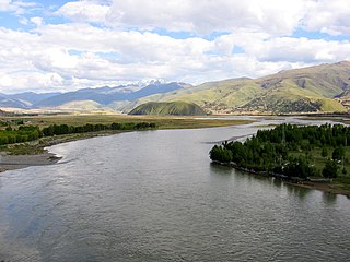
Samada is a township in the Tibet Autonomous Region of China.
This article does not cite any sources .(September 2018) (Learn how and when to remove this template message) |
Samada is a township in the Tibet Autonomous Region of China.
| Wikimedia Commons has media related to Samada . |
Coordinates: 28°24′N89°30′E / 28.400°N 89.500°E
| | This Tibet location article is a stub. You can help Wikipedia by expanding it. |

Paro District is a district (dzongkhag), valley, river and town in Bhutan. It is one of the most historic valleys in Bhutan. Both trade goods and invading Tibetans came over the pass at the head of the valley, giving Paro the closest cultural connection with Tibet of any Bhutanese district. The dominant language in Paro is Dzongkha, the national language.

Thubten Gyatso was the 13th Dalai Lama of Tibet.
The Yalong River, or Nyag Chu, is a major tributary river of the Yangtze River in Southwest China. With a length of 1,323 km (822 mi), the Yalong River flows from north to south through the Hengduan Mountains in western Sichuan Province.

The Tanggu La, Tangla Pass, or Tanggu Pass is a wide mountain pass in Southwest China over 5,000 meters (16,000 ft) in elevation, which utilized by both the Qinghai–Tibet Highway and Qinghai–Tibet Railway to cross the Tanggula Mountains. These mountains on the Tibetan Plateau separate the Tibet Autonomous Region from the Qinghai province, and also form part of the watershed separating the Yangtze River to the north from a zone of endorheic basins with internal drainage to the south.

Kangmar Town is a town in the Kangmar County of the Shigatse Prefecture in the Tibet Autonomous Region of the China, at an elevation of 5,358 m (17,581 ft). It lies very close to the border with Bhutan.

Gyantse County officially Gyangzê County is a county of Xigazê in the Tibet Autonomous Region. Its main settlement is Gyantse Town known for its monasteries.
Cawarong or Tsawarong is a township in Zayü County, Tibet Autonomous Region of China. It lies at an altitude of 2,003 metres. Formerly known as Tsarung, it was traditionally a southern gateway and trade route into Tibet from Yunnan, forming part of the tea-horse road. It is a very arid area with little rainfall. An unsealed road cut into the cliffs above the Nu River links it to Bingzhongluo in Yunnan. Cawarong is a major step on the Khora of the Khawa Karpo.

Nagarzê is a township and seat of Nagarzê County in the Tibet Autonomous Region of China. It lies at an altitude of 4452 metres.
Rindü is a village and township in the Tibet Autonomous Region of China.
Gyinkar is a village and township in the Tibet Autonomous Region of China.
Sapügang is a village and township in the Tibet Autonomous Region of China.
Tobgyai is a village and township in the Tibet Autonomous Region of China.
Mentang Raktsek is a township in Baingoin County, Tibet Autonomous Region, People's Republic of China.
Kamru is a village and township in the Tibet Autonomous Region of China.
Kardoi is a village and township in the Tibet Autonomous Region of China.
Karmai is a village and township in the Tibet Autonomous Region of China.
Lêba is a village and township in the Tibet Autonomous Region of China.
Lungmar is a village and township in the Tibet Autonomous Region of China.
Rinbung is a township and seat of Rinbung County in the Shigatse Prefecture of the Tibet Autonomous Region of China.
Litang Town is the administrative centre of Litang County in the southwest of the Garzê Tibetan Autonomous Prefecture in Sichuan Province of China.