Dnipropetrovsk Oblast, is an oblast (province) in simultaneously southern, eastern and central Ukraine, the most important industrial region of the country. It was created on February 27, 1932. Dnipropetrovsk Oblast has a population of about 3,096,485, approximately 80% of whom live centering on administrative centers: Dnipro, Kryvyi Rih, Kamianske, Nikopol and Pavlohrad. The Dnieper River runs through the oblast.

Dnipro is Ukraine's fourth-largest city, with about one million inhabitants. It is located in the eastern part of Ukraine, 391 km (243 mi) southeast of the Ukrainian capital Kyiv on the Dnipro River, after which its name is derived. Dnipro is the administrative centre of Dnipropetrovsk Oblast. It hosts the administration of Dnipro urban hromada. Dnipro has a population of 968,502.

An oblast in Ukraine, sometimes translated as region or province, is the main type of first-level administrative division of the country. Ukraine's territory is divided into 24 oblasts, as well as one autonomous republic and two cities with special status. Ukraine is a unitary state, thus the oblasts do not have much legal scope of competence other than that which is established in the Ukrainian Constitution and devolved by law. Articles 140–146 of Chapter XI of the constitution deal directly with local authorities and their competence.

Kamianske, previously known as Dniprodzerzhynsk from 1936 to 2016, is an industrial city in Dnipropetrovsk Oblast, Ukraine, and a port on the Dnieper River. It serves as the administrative center of Kamianske Raion and Kamianske urban hromada. Population: 226,845.

Pavlohrad is a city in central east Ukraine, located within Dnipropetrovsk Oblast. It serves as the administrative center of Pavlohrad Raion. Its population is approximately 101,430.

Samar, formerly known as Novomoskovsk until 2024, is a city and municipality in Dnipropetrovsk Oblast, Ukraine. It serves as the administrative center of Samar Raion within the oblast. Samar is located predominantly on the right bank of the Samara River, a left tributary of the Dnieper River. The city is located 27 kilometres (17 mi) from the administrative center of the oblast, Dnipro. As of January 2022, Novomoskovsk's population was approximately 69,855.

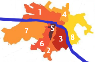
Shevchenkivskyi District is a right-bank urban district of the city of Dnipro, located in southern Ukraine. It is formerly known as Babushkinskyi District.

Amur-Nyzhniodniprovskyi District, formerly known as Nyzhniodniprovskyi District, is an urban district of the city of Dnipro, in southern Ukraine. It is located on the city's north and on the left-bank of Dnieper River along with the city's Industrialnyi and Samarskyi districts.

Industrialnyi District is an urban district of the city of Dnipro, in southern Ukraine. It is located at the northern portion of the city on the left-bank of Dnieper River along with the city's Amur-Nyzhniodniprovskyi and Samarskyi districts.

Novokodatskyi District is an urban district of the city of Dnipro, in central Ukraine. It is in the western part of the city and borders the city of Kamianske.

Tsentralnyi District is an urban district of the city of Dnipro, in southern Ukraine. It is located in the city's center and on the right-bank of the Dnieper River.

Chechelivskyi District is an urban district of the city of Dnipro, in southern Ukraine. It is located in the city's center on the southwestern outskirts and the right-bank of the Dnieper River.

Sobornyi District is an urban district of the city of Dnipro, in southern Ukraine. It is located in the city's center on the right-bank of the Dnieper River.
Taromske was an urban-type settlement of the Novokodatskyi District of the Dnipro Municipality in southern Ukraine. Its population was 15,500 in 2005.
Mahdalynivka is a rural settlement in Samar Raion, Dnipropetrovsk Oblast, Ukraine. It hosts the administration of Mahdalynivka settlement hromada, one of the hromadas of Ukraine. Population: 6,119.
Samar is a neighborhood of the Samarskyi District of the city of Dnipro in southern Ukraine. It is located at the mouth of Samara River on its right bank where the river enters Dnieper. Samar, originally a Cossack settlement, was destroyed in 17th century and consequently rebuilt in a different location, and is thus sometimes called Old Samar to distinguish it from the New Samar.
Slobozhanske is a rural settlement in Dnipro Raion, Dnipropetrovsk Oblast, Ukraine. The populated place is part of the Dnipro urban sprawl being its immediate northern suburb. Slobozhanske hosts the administration of Slobozhanske settlement hromada, one of the hromadas of Ukraine. Population: 14,661.

Slobozhanske settlement hromada is a territorial community in Ukraine, in Dnipro Raion of Dnipropetrovsk Oblast. The administrative center is the settlement of Slobozhanske. It was formed on August 14, 2015, by merging the Yuvileyne settlement council and the Stepove village council of Dnipropetrovsk Raion.
The history of Dnipro starts with the human settlement of the city, which is first attested in the Neolithic period. In the Antiquity, the area of the future city was ruled by Scythians and a number of other tribes. In the Middle Ages, an Orthodox monastery existed on one of the islands on the Dneper, which now lays in the city borders. The region was devastated by the Mongol invasion of Rus' and later came under the influence of the Grand Duchy of Lithuania (later the Polish-Lithuanian Commonwealth. During this period, settlements of Zaporozhian Cossacks appeared on the lands of modern-day Dnipro, and a Polish fortress was constructed on one of the rapids south of the city.
Olexandrivka is a village in Dnipro Raion Dnipropetrovsk Oblast Ukraine. The village is part of Slobozhanska settlement hromada.


