Sambankulam is a village in District of Tirunelveli.The spoken language in this area is Tamil.Sambankulam is located on the bank of Gadananathi River (Kadana Nadi), which means "kadana dam river" and flows throughout the year. The area is surrounded by mountains and hills which are part of the Western Ghats. Sambankulam is located between two tourist spots - Sivasailam temple 2km from the village.and Gadananathi River dam,3km from the village. The village has many paddy fields, mango orchards, vegetable gardens, palm trees and tall coconut trees.
Bus and train are the major transport methods. The nearest railway station is in Alwarkurichi , 5km from the village.
Climate
The place will be greenish even during the summer months. During the month of Chitirai (mid April) to Puratasi (mid October) wind from the mountains blows gently and rain sprinkles and makes the place cool.
Related Research Articles
Sri Lanka, formerly called "Ceylon", is an island nation in the Indian Ocean, southeast of the Indian subcontinent, in a strategic location near major Indian Ocean sea lanes. The nation has a total area of 65,612 km2, with 62,707 km2 of land and 2,905 km2 of water. Its coastline is 1,340 km (830 mi) long. The main island of Sri Lanka has an area of 65,268 km2; it is the twenty-fifth largest island of the world by area. Dozens of offshore islands account for the remaining 342 km2 area. The largest offshore island, Mannar Island, leads to Adam's Bridge.
The Rhodopes are a mountain range in Southeastern Europe, with over 83% of its area in southern Bulgaria and the remainder in Greece. Golyam Perelik is its highest peak at 2,191 meters (7,188 ft). The mountain range gives its name to the terrestrial ecoregion Rodope montane mixed forests that belongs in the temperate broadleaf and mixed forests biome and the Palearctic realm. The region is particularly notable for its karst areas with their deep river gorges, large caves and specific sculptured forms, such as the Trigrad Gorge.
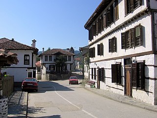
Zlatograd is a town in Smolyan Province, Southern-central Bulgaria. It is the administrative centre of the homonymous Zlatograd Municipality. In December 2009, the town had a population of 7,110.
Okutama is a town located in the western portion of Tokyo Metropolis, Japan. As of 1 April 2021, the town had an estimated population of 4,949, and a population density of 22 persons per km2. The total area of the town is 225.53 square kilometres (87.08 sq mi).
Fontana Dam is a hydroelectric dam on the Little Tennessee River in Swain and Graham counties, North Carolina, United States. The dam is operated by the Tennessee Valley Authority, which built the dam in the early 1940s to satisfy the skyrocketing electricity demands in the Tennessee Valley to support the aluminum industry at the height of World War II; it also provided electricity to a formerly rural area.
The Thamirabarani or Tamraparni or Porunai is a perennial river that originates from the Agastyarkoodam peak of Pothigai hills of the Western Ghats, above Papanasam in the Ambasamudram taluk. It flows through Tirunelveli and Thoothukudi districts of the Tamil Nadu state of southern India into the Gulf of Mannar. It was called the Tamraparni River in the pre-classical period, a name it lent to the island of Sri Lanka. The old Tamil name of the river is Porunai. From the source to sea, the river is about 128 kilometres (80 mi) long and is the only perennial river in Tamil Nadu. This river flows towards north direction initially. However, it changes to east direction later.
Bhoothathankettu is a dam and tourist spot in Ernakulam district in Kerala, India. It is situated outside the village of Pindimana, about 10 km away from the town of Kothamangalam and 50 km away from the main city of Kochi. The original natural dam has been supplemented by a modern dam impounding the Bhoothathankettu Reservoir.
Pinet is a municipality located in the north-east of the comarca of Vall d'Albaida in the south of the province of Valencia, Valencian Community, Spain, and some 82.6 km from the regional capital, Valencia.
Norris Dam State Park is a state park in Anderson County and Campbell County, Tennessee, in the southeastern United States. The park is situated along the shores of Norris Lake, an impoundment of the Clinch River created by the completion of Norris Dam in 1936. The park consists of 4,038 acres (16.34 km2) managed by the Tennessee Department of Environment and Conservation. The park also administers the Lenoir Museum Complex, which interprets the area's aboriginal, pioneer, and early 20th-century history.
'Bold text
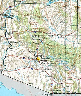
A general map of Arizona
The Drina is a 346 km (215 mi) long international river, which forms a large portion of the border between Bosnia and Herzegovina and Serbia. It is the longest tributary of the Sava River and the longest karst river in the Dinaric Alps which belongs to the Danube river watershed. Its name is derived from the Roman name of the river which in turn is derived from Greek.
Chempanoda/Chempanod is a village towards the north east of Kozhikode district of Kerala in India. This place lies adjacent to the tourist spot Peruvannamuzhi. Chempanoda is a tourist spot. This village is surrounded by two rivers and there are mountains to the east. People here are mainly into farming business and are planters of rubber trees, coconut trees, areca nut trees etc. The road through the village leads to another village named Poozhithode which is a hilly area of reserved forests.
Sly Park Dam is located near Pollock Pines, California in the United States. The dam impounds Sly Park Creek and Hazel Creek, natural tributaries of the North Fork Cosumnes River, to form a 41,000 acre foot (51,000 dam3), 650-acre (260 ha) reservoir called Jenkinson Lake. It was constructed as part of the American River Division of the Central Valley Project to provide irrigation water to a portion of El Dorado County, California. The dam was begun on May 1953, with clearing operations, and was completed in mid 1955.
Gadananathi (கடனாநதி)also can be called as Karunai aaru or Gadananadhi or Gatananadhi or Kadananathi or Kadananadhi is a river flowing in the Tirunelveli district of the Indian state of Tamil Nadu.
Ramanathi (ராமாநதி) is a river flowing in the Tenkasi of the Indian state of Tamil Nadu.Gadananathi originates from Agasthyamalai Biosphere Reserve.This river enters Gadananathi River in Kizha Ambur. The Ramanadhi has 7 anicuts, a reservoir of 4,300,000 cubic metres (3,500 acre⋅ft), and irrigates 20.23 square kilometres (7.81 sq mi) of wetlands. This river flows on many villages like Alwarkurichi, Ravanasamudram, Pottalpudur, Pillaukulam.The Gadananathi is fed by Thekkaru and Ramanathi Rivers.This was proposed and signed by KAMARAJ and opened by Karunanithi.
Poovankurichi or Poovan Kurichi is a hamlet situated in the district of Tirunelveli near Ambasamudram, Tamil Nadu, India. Poovan means "wind" and kurichi means "mountain or a place located near a mountain".
Sivasailam {Sivasaailam per the Indian census) is a village located on the bank of River Gadananathi River in Ambasamudram taluk, Tirunelveli district, Tamil Nadu, India. The census village code is 642940. The postal code is 627412. The spoken language in this area is Tamil.
Karuthapillaiyur is a village in the district of Tenkasi near Ambasamudram, Tamil Nadu, India.
Kovankulam is a hamlet in the district of Tirunelveli near Ambasamudram, Tamil Nadu, India. The spoken language in this area is Tamil.This village is located on Ambur-Papanasam Road.
Kadana is a village and tehsil in the Mahisagar district of the Indian state of Gujarat. It is situated on the riverbank of Mahi River. Kadana is the site of the Kadana Dam, which generates 240MW of hydroelectric power. The dam was built between 1979 and 1989 and is a part of Santrampur. The construction of a new bridge over the Mahi river, near to the dam, started at the end of 2016.
References
This page is based on this Wikipedia article Text is available under the CC BY-SA 4.0 license; additional terms may apply. Images, videos and audio are available under their respective licenses.