
Madagascar is a large island in the Indian Ocean off the eastern coast of Southern Africa, east of Mozambique. It has a total area of 587,040 square kilometres (226,660 sq mi) with 581,540 square kilometres (224,530 sq mi) of land and 6,900 square kilometres (2,700 sq mi) of water. Madagascar is the fourth-largest island and the second-largest island country in the world. The highest point is Maromokotro, in the Tsaratanana Massif region in the north of the island, at 2,876 metres (9,436 ft). The capital Antananarivo is in the Central Highlands near the centre of the island. It has the 25th largest exclusive economic zone of 1,225,259 km2 (473,075 sq mi). Madagascar is 400 kilometres east of mainland Africa.

Tropical and subtropical moist broadleaf forests (TSMF), also known as tropical moist forest, is a subtropical and tropical forest habitat type defined by the World Wide Fund for Nature.

Antsiranana is a former province of Madagascar with an area of 43,406 km2. It had a population of 1,188,425. Its capital was Antsiranana. A diversity of ethnic groups are found in the province, including Anjoaty, Sakalava, Antakarana, Tsimihety, Antemoro, Betsimisaraka, Antandroy, etc.

The Madagascar lowland forests or Madagascar humid forests are a tropical moist broadleaf forest ecoregion found on the eastern coast of the island of Madagascar, home to a plant and animal mix that is 80 to 90% endemic, with the forests of the eastern plain being a particularly important location of this endemism. They are included in the Global 200 list of outstanding ecoregions.

The Madagascar subhumid forests are a tropical moist broadleaf forest ecoregion that covers most of the Central Highlands of the island of Madagascar. They are included in the WWF's Global 200 list of outstanding ecoregions. Most of the original habitats have been lost due to human pressure.

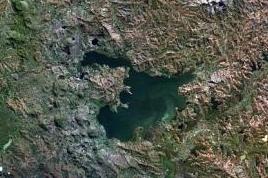
Lake Alaotra is the largest lake in Madagascar, located in Alaotra-Mangoro Region and on the island's northern central plateau. Its basin is composed of shallow freshwater lakes and marshes surrounded by areas of dense vegetation. It forms the center of the island's most important rice-growing region. It is a rich habitat for wildlife, including some rare and endangered species, as well as an important fishing ground. Lake Alaotra and its surrounding wetlands cover 7,223 square kilometres (2,789 sq mi), and include a range of habitats, including open water, reedbeds, marshes, and rice paddies. The lake itself covers 900 km2 (350 sq mi). Lake Alaotra was declared a wetland of international importance under the international Ramsar Convention on February 2, 2003.
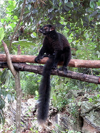
The black lemur is a species of lemur from the family Lemuridae. Like all lemurs, it is endemic to Madagascar. Originally, the species was thought to have two subspecies, Eulemur macaco macaco and Eulemur macaco flavifrons, both of which were elevated to species status by Mittermeier et al. in 2008 to Eulemur macaco and Eulemur flavifrons respectively. The most startling difference between the two species is the eye colour; Eulemur flavifrons, the blue-eyed black lemur, has blue eyes, while Eulemur macaco, the black lemur, has brown or orange eyes, and also has ear tufts.

Galidiinae is a subfamily of carnivorans that is restricted to Madagascar and includes six species classified into four genera. Together with the three other species of indigenous Malagasy carnivorans, including the fossa, they are currently classified in the family Eupleridae within the suborder Feliformia. Galidiinae are the smallest of the Malagasy carnivorans, generally weighing about 600 to 900 g. They are agile, short-legged animals with long, bushy ringed tails.
Philippia is a formerly accepted genus of plant in the family Ericaceae, now treated as a synonym of Erica. Its species ranged from southern to tropical Africa, Madagascar, and the Mascarene Islands. Philippia was a characteristic Afromontane genus in southern and eastern Africa, found in montane forests and shrublands. The genus name Philippia is in honor of Rodolfo Amando Philippi (1808–1904), who was a German–Chilean paleontologist and zoologist.
Manongarivo Reserve is a wildlife reserve in the North-West of Madagascar in the region of Diana.

The Tsiribihina is a river of western Madagascar.
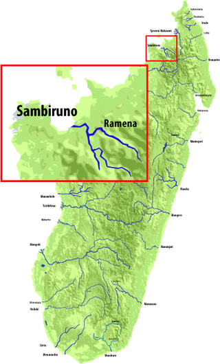
The Sambirano is a river of northwestern Madagascar in the region of Diana. It has its sources at the Maromokotra peak and flows through the Tsaratanana Reserve to the Indian Ocean. Its delta occupies 250 km2.
The Guineo-Congolian region is a biogeographical region in Africa straddling the Equator and stretching from the Atlantic Ocean through the Congo Basin to the Congo / Nile divide in Rwanda and Burundi. Formerly, this region was largely covered in rain forest, on both well-drained sites and in swamp forests, but little undisturbed primary forest now remains, having been replaced in many areas by savanna and secondary-growth forest.

The Sakeny River is a river in Western Madagascar. It is a tributary of the Tsiribihina River.
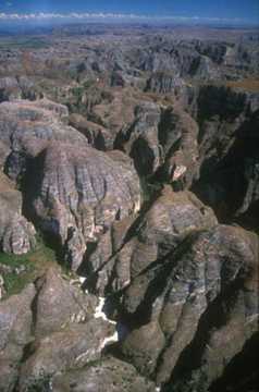
The Makay Massif is a mountain range in western Madagascar.
The Maharivo is a river in Menabe region of western Madagascar. It originates on the Makay Massif and flows westwards into the Indian Ocean. It is approximately 165 km long from source to sea, and drains a basin of 4,700 km2 The climate of the region is semi-arid to arid, and the upper reaches of the river are often dry for part of the year. There are manroves in the river delta. The lower portion of the river and its delta are in Kirindy Mitea National Park.

The Mahavavy Sud, also known as the Mahavavy South, is a river in western Madagascar. It flows from south to north through the regions of Melaky, Betsiboka, Bongolava and Boeny. It has a length of approximately 410 km (250 mi), and drains a basin of 16,475 km2 (6,361 sq mi). It is distinct from the Mahavavy Nord several hundred km to the north.
Lake Itasy is a lake in central Madagascar. It is located in Itasy Region. It is situated in the municipalities of Ampefy, Soavinandriana, Manazary and Analavory.

The Lily River is a river in central Madagascar. It is the main outflow of Lake Itasy, and flows northwestward to join the Sakay River, a tributary of the Tsiribihina.
Nothofagus carrii is a species of tree in the family Nothofagaceae. It is endemic to New Guinea.

