Related Research Articles

Haida Gwaii, also known as the Queen Charlotte Islands, is an archipelago located between 55–125 km (34–78 mi) off the northern Pacific coast of Canada. The islands are separated from the mainland to the east by the shallow Hecate Strait. Queen Charlotte Sound lies to the south, with Vancouver Island beyond. To the north, the disputed Dixon Entrance separates Haida Gwaii from the Alexander Archipelago in the U.S. state of Alaska.

Graham Island is the largest island in the Haida Gwaii archipelago, lying off the mainland coast of British Columbia, Canada. It is separated by the narrow Skidegate Channel from the other principal island of the group to the south, Moresby Island. It has a population of 3,858, an area of 6,361 km2 (2,456 sq mi), and is the 101st largest island in the world and Canada's 22nd largest island.

Queen Charlotte Sound is a sound of the Pacific Ocean in British Columbia, Canada, between Vancouver Island in the south and Haida Gwaii in the north. It merges with Hecate Strait in the north and Queen Charlotte Strait in the south.

Hecate Strait is a wide but shallow strait between Haida Gwaii and the mainland of British Columbia, Canada. It merges with Queen Charlotte Sound to the south and Dixon Entrance to the north. About 140 kilometres (87 mi) wide at its southern end, Hecate Strait narrows in the north to about 48 kilometres (30 mi). It is about 260 kilometres (160 mi) in length.

John Meares was an English navigator, explorer, and maritime fur trader, best known for his role in the Nootka Crisis, which brought Britain and Spain to the brink of war.
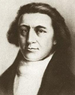
Robert Gray was an American merchant sea captain who is known for his achievements in connection with two trading voyages to the northern Pacific coast of North America, between 1790 and 1793, which pioneered the American maritime fur trade in that region. In the course of those voyages, Gray explored portions of that coast and in the year 1790 he completed the first American circumnavigation of the world. He was also noted for coming upon and naming the Columbia River, in 1792, while on his second voyage.

Joseph Ingraham (1762–1800) was an American sailor and maritime fur trader who discovered several islands of the Marquesas Islands while on his way to trade along the west coast of North America. He was also a prisoner in the American Revolutionary War and an officer in the United States Navy.
The Queen Charlottes Gold Rush was a gold rush in southern Haida Gwaii of what is now the North Coast of British Columbia, Canada, in 1851.
James Colnett was an officer of the British Royal Navy, an explorer, and a maritime fur trader. He served under James Cook during Cook's second voyage of exploration. Later he led two private trading expeditions that involved collecting sea otter pelts in the Pacific Northwest of North America and selling them in Canton, China, where the British East India Company maintained a trading post. Wintering in the recently discovered Hawaiian Islands was a key component of the new trade system. Colnett is remembered largely for his involvement in the Nootka Crisis of 1789—initially a dispute between British traders and the Spanish Navy over the use of Nootka Sound on Vancouver Island that became an international crisis that led Britain and Spain to the brink of war before being peacefully resolved through diplomacy and the signing of the Nootka Conventions.

The maritime fur trade, a ship-based fur trade system, focused largely on acquiring furs of sea otters and other animals from the indigenous peoples of the Pacific Northwest Coast and natives of Alaska. Entrepreneurs also exploited fur-bearing skins from the wider Pacific and from the Southern Ocean.
William Douglas was a Scottish ship captain and an oceanographer maritime fur trader during the late 18th century. He worked with the British trader and Captain John Meares, commanding the ship Iphigenia Nubiana. He was involved in the Nootka Crisis of 1789, which brought Britain and Spain to the brink of war. A few years later he was captain of the American ship Grace. In 1791 he partnered with Captain John Kendrick in an attempt to open trade with Japan.

James Charles Stuart Strange was a British officer of the East India Company, one of the first maritime fur traders, a banker, and a Member of Parliament.
Union was an American sloop built in Somerset, Massachusetts in 1792. It is best known for its circumnavigation of the world, 1794–1796, under the maritime fur trader John Boit.
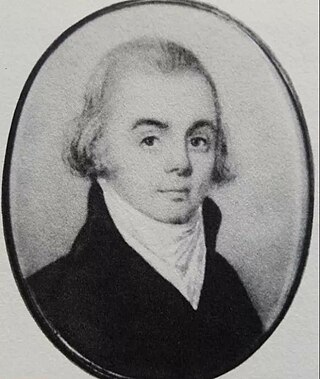
John Boit Jr. was one of the first Americans involved in the maritime fur trade. He sailed as fifth mate under Captain Robert Gray on the second voyage of the Columbia Rediviva, 1790–1793. During the voyage he wrote a short but important journal in which he described the first time the Columbia River was located by Europeans or European Americans. From 1794–1796 he captained the Union on another maritime fur trading circumnavigation voyage from New England to the Pacific Northwest and China. Later he captained other vessels including the George and the slave ship Mac.
Kaigani was a major trading site for maritime fur traders and the Kaigani Haida during the maritime fur trade era of approximately 1790 to 1850. The term was used for a few nearby anchorages near several Haida settlements such as Kasaan. During this time Kaigani was one of the most popular sites for trading vessels on the Pacific Northwest coast. Hundreds of trading vessels, mostly American, visited during this time, mostly seeking sea otter skins to take to China, where they commanded a high price.
Nahwitti was a Kwakwakaʼwakw First Nation village and a major trading site during the maritime fur trade era of approximately 1790 to 1850. Today it is an Indian reserve under the administration of the Kwakwakaʼwakw Tlatlasikwala Nation. It is located near the northern tip of Vancouver Island, at Cape Sutil on Queen Charlotte Sound, near Hope Island and the Nahwitti River, east of Cape Scott, and not far from historic Fort Rupert and modern Port Hardy.

Various Imperial and colonial actions against Haida Gwaii Authorities have been undertaken since the 19th century. The indigenous peoples of Haida Gwaii often reacted violently to European and American ships which trespassed in their waters and lands. From the 18th to 19th centuries, various skirmishes took place between Haida authorities and European and American merchantmen and warships. Canadian settlers did not arrive on Haida Gwaii islands until 1900, and many Canadian colonial police actions attempted to assault the Haida Gwaii authorities and citizens. The indigenous Haida population was decimated by diseases such as smallpox which were introduced accidentally by way of Fort Victoria. The presence of foreign diseases, to which the Haida had no immunity, along with some colonial hostility, meant that the numbers of Haida citizens was reduced from tens of thousands to 588 by 1915. This erosion of Haida cultural institutions was essential to open the way for subsequent British and Canadian incursions and jurisdictional claims.
Cape Sutil is the headland at the northernmost point of Vancouver Island, in the Canadian Province of British Columbia.
References
- "Crowell Rock". BC Geographical Names .
- "Crowell Point". BC Geographical Names .
- "Hancock Point". BC Geographical Names .
| | This biography about a Canadian businessperson is a stub. You can help Wikipedia by expanding it. |
| | This Massachusetts-related article is a stub. You can help Wikipedia by expanding it. |