
Aragua State is one of the 23 states of Venezuela. It is located in the north-central region of Venezuela. It has plains and jungles and Caribbean beaches. The most popular are Cata and Choroni. It has Venezuela's first national park which is called Henri Pittier. The capital is Maracay, other important cities include Turmero and El Limón.

Valencia is the capital city of Carabobo State and the third-largest city in Venezuela.

Carabobo State is one of the 23 states of Venezuela, located in the north of the country, about two hours by car from Caracas. The state capital city is Valencia, which is also the country's main industrial center. The state's area is 4,369 km2 (1,687 sq mi) and as of the 2011 census, had a population of 2,245,744.

Cojedes State is one of the 23 states of Venezuela. The state capital is San Carlos.

Lara State is one of the 23 states of Venezuela. Lara is located in the Central-Western Region, Venezuela. The state capital is Barquisimeto.

The State of Mérida commonly known simply as Mérida is one of the 23 states of Venezuela. The state capital is Mérida, in the Libertador Municipality.

Trujillo State is one of the 23 states of Venezuela. Its capital is Trujillo and the largest city is Valera. The state is divided into 20 municipalities and 93 parishes. Trujillo State covers a total surface area of 7,198 km2 (2,779 sq mi) and, has a 2011 census population of 686,367.
Yaracuy is one of the 23 states of Venezuela. Yaracuy is located in the Central-Western Region, Venezuela. It is bordered by Falcón in the north, in the west by Lara, in the south by Portuguesa and Cojedes and in the east by Cojedes and Carabobo.

The Girardot Municipality is one of the 18 municipalities (municipios) that makes up the Venezuelan state of Aragua. According to the 2011 census by the National Institute of Statistics of Venezuela, the municipality has a population of 407,109. The city of Maracay is the shire town of the Girardot Municipality.
Los Guayos is a town in Carabobo State, Venezuela, northwest of the Valencia Lake. It is the capital of the Los Guayos Municipality and is part of Valencia's metropolitan area.

The Los Guayos Municipality is one of the 14 municipalities (municipios) that makes up the Venezuelan state of Carabobo and, according to the 2011 census by the National Institute of Statistics of Venezuela, the municipality has a population of 149,646. The town of Los Guayos is the shire town of the Los Guayos Municipality.

The Naguanagua municipality is one of the 14 municipalities (municipios) that makes up the Venezuelan state of Carabobo and, according to the 2011 census by the National Institute of Statistics of Venezuela, the municipality has a population of 157,437. The town of Naguanagua is the shire town of the Naguanagua Municipality. It forms part of the greater Valencia Metropolitan Area in Venezuela. It is in the valley of the Cabriales River at the base of Cerro El Café and the El Trigal Mountain. Valencia and Naguanagua form a continuous urban area. The highway that runs from the centre of Valencia towards Puerto Cabello passes through this community; Bolivar Avenue in Valencia becomes University Avenue in Naguanagua on the northern side of a traffic roundabout, or redoma.

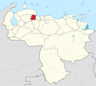
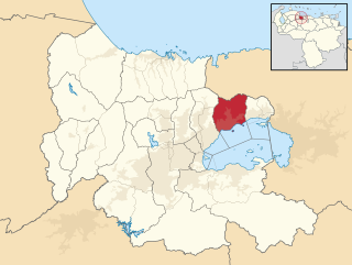
The San Diego Municipality is one of the 14 municipalities (municipios) that makes up the Venezuelan state of Carabobo and, according to the 2011 census by the National Institute of Statistics of Venezuela, the municipality has a population of 93,257. The town of San Diego is the municipal seat of the San Diego Municipality.
The San Joaquín Municipality is one of the 14 municipalities (municipios) that makes up the Venezuelan state of Carabobo and, according to the 2011 census by the National Institute of Statistics of Venezuela, the municipality has a population of 64,124. The town of San Joaquín is the municipal seat of the San Joaquín Municipality.

The Valencia Municipality is one of the 14 municipalities (municipios) that makes up the Venezuelan state of Carabobo and, according to the 2011 census by the National Institute of Statistics of Venezuela, the municipality has a population of 829,856. The city of Valencia is the shire town of the Valencia Municipality.
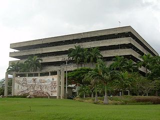
The University of Carabobo is an autonomous, public university of Venezuela located in Valencia, Venezuela. It offers graduate and postgraduate studies in different areas. The university offers a lot of green spaces for student recreation, as well architectural art around the faculties, a theater, and two dining halls. There are around 65,000 students, mostly coming from the central part of the country.
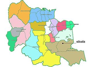
Guigue is a city in the south of the Valencia Lake, in Carabobo, Venezuela. It is the capital of the Carlos Arvelo Municipality and of the Guigue parish. The Guigue River flows through the city, draining in Lake Valencia.
The San Esteban National Park is located in Carabobo, Venezuela.
Tocuyito is a city of Venezuela, capital of the Libertador Municipality in Carabobo State. It is part of the metropolitan area of Valencia. This city is considered the entry point to Valencia from the motorways that lead to the Southwest (Barquisimeto) and South.

The Isla Multiespacio Complex is among the most ambitious architectural projects of recent years in Venezuela. This is currently under construction in the Municipality of San Diego in Valencia, Carabobo State (Venezuela). Its construction started in July 2009 and is expected to be completed in 2018. From the Isla Multiespacio stands the highest office tower in the Midwest, the skyscraper would be 150 m initially but then they decided to increase the height to 252.8 m and 65 flooring, it's the tallest building in Venezuela, built the first private theater in the nation and a hotel designed for guests with joy social areas looking at the city from above, among other projects.

