
Marina or Malintzin, more popularly known as La Malinche, a Nahua woman from the Mexican Gulf Coast, became known for contributing to the Spanish conquest of the Aztec Empire (1519–1521), by acting as an interpreter, advisor, and intermediary for the Spanish conquistador Hernán Cortés. She was one of 20 enslaved women given to the Spaniards in 1519 by the natives of Tabasco. Cortés chose her as a consort, and she later gave birth to their first son, Martín – one of the first Mestizos in New Spain.
Tlaxcala, officially the Free and Sovereign State of Tlaxcala, is one of the 32 federal entities that comprise the Federal Entities of Mexico. It is divided into 60 municipalities and the capital city and the largest city is Tlaxcala de Xicohténcatl.
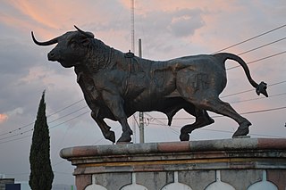
Huamantla is a small city in the municipality of the same name in the eastern half of the Mexican state of Tlaxcala. The area has a long indigenous history, but the city itself was not founded until the early colonial period, in the 1530s. It is mostly agricultural but it is best known for its annual homage to an image of the Virgin Mary called Our Lady of Charity. This includes a month of festivities, the best known of which are the “night no one sleeps” when residents create six km of “carpets” on the streets made from colored sawdust, flowers and other materials. The other is the “Huamantlada” a running of the bulls similar to that in Pamplona.
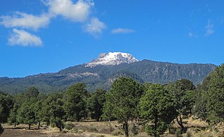
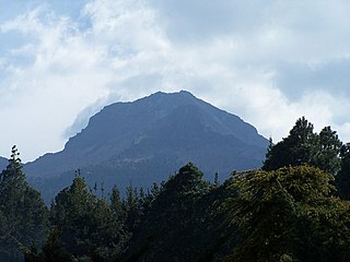
La Malinche, also known as Matlalcueye or Malintzin, is an inactive volcano located in the states of Tlaxcala and Puebla in Mexico. Officially, its summit reaches 4,461 metres (14,636 ft) above sea level, though it is generally considered to be closer to 4,440 metres (14,567 ft), using GPS measurements. It is the highest peak in Tlaxcala, the fifth-highest in Puebla, the sixth-highest in Mexico, the 23rd-highest in North America, and the 252nd-highest in the world. Its height above nearby cities varies from 1,908 metres (6,260 ft) above Huamantla, 2,461 metres (8,074 ft) above Villa Vicente Guerrero, 2,221 metres (7,287 ft) above Tlaxcala, to 2,299 metres (7,543 ft) above Puebla. The summit is 22.4 kilometres (13.9 mi) from Tlaxcala, 28.3 kilometres (17.6 mi) from Puebla, and 118 kilometres (73 mi) from Mexico City. The climate is cold near the summit and mild on the lower slopes.

Apizaco is a city in Apizaco Municipality located near the geographic center of the Mexican state of Tlaxcala, approximately 25 minutes by car from the state's capital city of Tlaxcala. Those seeking to reach the port of Veracruz by railroad from Mexico City must travel through Apizaco. The city began because of its location on this railroad.

The Archdiocese of Morelia is a Latin Church ecclesiastical territory or archdiocese of the Catholic Church in western central Mexico. It was erected on 11 August 1536 as the Diocese of Michoacán.
La Malinche National Park is located in the states of Tlaxcala in Central Mexico. The park is east of Mexico City, and about 44 kilometres (27 mi) from the capital city
Tlaxcala, Tlaxcala.

Xochitecatl is a pre-Columbian archaeological site located in the Mexican State of Tlaxcala, 18 km southwest of Tlaxcala city. The major architecture dates to the Middle Preclassic Period but occupation continued, with one major interruption, until the Late Classic, when the site was abandoned. There is some evidence of ritual activity in the Postclassic and Colonial Periods. The ruins cover an area of 12 hectares on top of a volcanic dome.

Cuautlancingo is a town and municipality in the state of Puebla, south-eastern Mexico. It is part of the Metropolitan area of Puebla. The town is bordered on the north by the state of Tlaxcala, on the east by Tlaxcala and the city of Puebla, on the south by the municipalities of San Pedro Cholula and Puebla, and on the west by the municipality of Coronango.

Puebla Municipality is a municipality in the State of Puebla in eastern Central Mexico. The municipality covers a total area of 534.32 square kilometres (206.30 sq mi). The City of Puebla is the municipal seat, as well as the capital of the state.

Ixtenco is a municipality in the Mexican state of Tlaxcala.
San Francisco Tetlanohcan is a municipality in Tlaxcala in south-eastern Mexico.

Tzompantepec is a town and its surrounding municipality located in the eastern portion of the Mexican state of Tlaxcala. It is located in the Central Mexican Plateau, almost entirely on the slopes of the La Malinche Volcano. The area was the earliest to be inhabited in Tlaxcala and it was also the site of the defeat of the Tlaxcallans in the early part of the Spanish Conquest. The municipality is mostly farmland but urban sprawl has limited both natural vegetation and wildlife.
Most Mexican states do not have an official flag. For these states, a de facto flag is used for civil and state purposes. State flags of Mexico have a 4:7 ratio and typically consist of a white background charged with the state's coat of arms.
Ixtenco is located in Ixtenco Municipality in the southeast of the Mexican state of Tlaxcala. It is a traditional Otomi community, which has conserved its agricultural economic base and various traditions. However, it is one of the poorest and least populated of the state's municipalities. The town's main landmark is the San Juan Bautista Parish and the municipality contains the remains of colonial era haciendas. The municipality lies on an old lava flow from the nearby La Malinche Volcano, which provides its volcanic soil, but because of the destruction of forests and overgrazing, erosion is a significant problem.

Tlaxcala handcrafts and folk art is that which comes from the smallest state in Mexico, located in the center-east of the country. Its best-known wares are the "canes of Apizaco", sawdust carpets and the making of Saltillo-style serapes. However, there are other handcraft traditions, such as the making of pottery, including Talavera type wares, cartoneria, metalworking and stone working. The state supports artisans through the activities of the Fideicomiso Fondo de la Casa de las Artesanía de Tlaxcala

Tlaxco is a town and its surrounding municipality in the Mexican state of Tlaxcala.
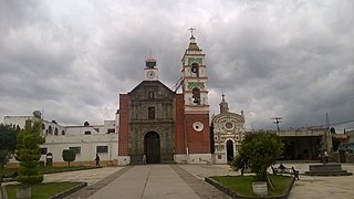
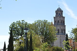
 At the top of Calle Hildalgo is San Francisco Tetlanohcan's Cathedral.
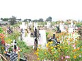 San Francisco Tetlanohcan has a flower covered cemetery.
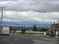 The Main Square of San Francisco Tetlanohcan

