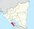
Granada is a city in western Nicaragua and the capital of the Granada Department. With an estimated population of 104,091 (2020), it is Nicaragua's ninth most populous city. Granada is historically one of Nicaragua's most important cities, economically and politically. It has a rich colonial heritage, seen in its architecture and structure.
Granada is a department in Nicaragua. It covers an area of 1040 km² and has a population of 212,663. The capital is the city of Granada, one of North America's oldest cities

Matagalpa is a department in central Nicaragua. It covers an area of 6,804 km² and has a population of 586,986. The capital is the city of Matagalpa with a population of about 108,000.

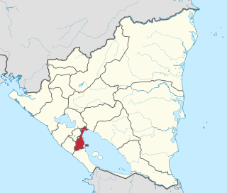
Rivas is a department of the Republic of Nicaragua. It covers an area of 2,162 km² and has a population of 181,665. The department's capital is the city of Rivas.
This is a list of the extreme points of Ireland – the points that are farthest north, south, east or west in Ireland. It includes the Republic of Ireland and Northern Ireland.
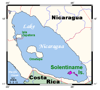
The Solentiname Islands are an archipelago towards the southern end of Lake Nicaragua in the Nicaraguan department of Río San Juan.

Teustepe is a municipality in the Boaco department of Nicaragua. It has a population of 26,800 and an extension of 645.73 km². The capital is the town of Teustepe, 94 km. from Managua with a population of 3,500.
Acoyapa is a town and a municipality in the Chontales Department of Nicaragua.
Condega is a municipality in the Estelí department of Nicaragua. It was officially incorporated on June 9, 1962. Condega is situated on the Pan-American Highway at a distance of 185 kilometers north of Managua, and at an altitude of 560 meters above sea level.

San Rafael del Sur is a town and a municipality in the Managua department of Nicaragua.
Tola is a municipality in the Rivas department of Nicaragua.

Altagracia is a municipality in the Rivas Department of Nicaragua.
Buenos Aires is a municipality in the Rivas department of Nicaragua, located on the western shore of Lake Nicaragua.
Cárdenas is a municipality in the Rivas department of Nicaragua, located on the southwestern shore of Lake Nicaragua.
Potosí is a municipality in the Rivas department of Nicaragua.
Paiwas is a municipality in the South Caribbean Coast Autonomous Region of Nicaragua.
This is a list of the extreme points of Central America, the points that are farther north, south, east, or west than any other location on the region. The list also included highest and lowest points and identifies the most extensive lake.
Rema Island is located in the southeastern part of Lake Tana in Ethiopia. It has a latitude and longitude of 11°48′N37°27′E.
Rio Brito or Brito River is a river in the southwestern part of Nicaragua that drains into the Pacific Ocean near Punta Brito, a promontory. The river valley was planned to be transformed by the Nicaraguan Canal and Development Project to serve as the conduit for the western part of the Nicaragua Canal. About 14.5 km upstream the triple-chambered Brito Lock would've been constructed by HK Nicaragua Canal Development Investment (HKND) to raise ships to the level of Lake Nicaragua.
This page is based on this
Wikipedia article Text is available under the
CC BY-SA 4.0 license; additional terms may apply.
Images, videos and audio are available under their respective licenses.