Huascarán National Park is a Peruvian national park that comprises most of the mountain range known as Cordillera Blanca which is part of the central Andes, in the region of Ancash. The park covers an area of 340.000 ha and is managed by the Peruvian Network of Protected Natural Areas: SERNANP. It was designated as a World Heritage Site in 1985 by UNESCO, is also a well-known mountaineering spot and harbors a unique biodiversity with plant species such as the Queen of the Andes, trees of the genera Polylepis and Buddleja, and animals such as spectacled bears, condors, vicunas and tarucas.
Chopicalqui or Chopicallqui is a mountain in the Cordillera Blanca area in the Andes of Peru. With a summit elevation of 6,354 metres (20,846 ft) above sea level it is one of the highest peaks of the Cordillera Blanca. It lies in Yungay Province, Ancash, between the mountains Huascarán and Contrahierbas.
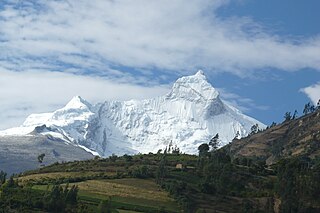
Huandoy or Tullparaju is a mountain located inside Huascarán National Park in Ancash, Peru. It is the second-tallest peak of the Cordillera Blanca section of the Andes, after Huascarán. These two peaks are rather nearby, separated only by the Llanganuco glacial valley at 3,846 m asl.

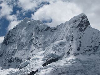
Huantsán,Huantsan or Tunsho is a mountain in the Andes of Peru. It is located in Ancash Region and is part of the Cordillera Blanca mountain range, a sub-range of the Andes. It has four peaks, with a maximum elevation of 6,369 metres (20,896 ft) above sea level.
Chinchey, also known as Rurichinchay, is a 6,309-metre-high (20,699 ft) mountain in the Cordillera Blanca in the Andes of Peru. It is located in the region of Ancash, most precisely between the districts of Aco, Independencia, and Huari.
Chacraraju or Chakraraju is a mountain in the Cordillera Blanca in the Andes range of Peru. The mountain has two distinctive peaks Chacraraju Oeste and Chacraraju Este. Chacraraju is located in the Ancash Region, Huaylas Province, Caraz District, and in the Yungay Province, Yungay District. It lies south and southeast of Pirámide. Lake Parón and the little Lake Chacra lie northwest of the mountain. The peak is accessible from the Pisco base camp at Cebollapampa.

Pucaranra is a mountain in the Cordillera Blanca in the Andes of Peru, about 6,147 metres (20,167 ft) high (although other sources cite an elevation of 6,156 metres. It is located in Ancash, southwest of mount Chinchey.

Caullaraju or Jeulla Rajo is a mountain in the Cordillera Blanca in the Andes of Peru, about 5,682 m (18,642 ft) high. It is located in the Ancash Region, Recuay Province. In the IGN-Peru map, the highest peak is reported to be named Jenhuaracra.

Cashan, Kashan or Tijeraspunta is a mountain in the Cordillera Blanca in the Andes of Peru, about 5,716 metres (18,753 ft) high. It is located in the Ancash Region, Huaraz Province, in the districts of Huaraz and Olleros. Cashan lies southeast of the town of Huaraz, southwest of Huantsán, west of Uruashraju and northeast of Shacsha.

Urus, also known as Yanaraju, is a 5,423-metre-high (17,792 ft) mountain in the Cordillera Blanca in the Andes of Peru. It located between Carhuaz and Huaraz provinces, in Ancash. Urus lies in Huascarán National Park, west of Tocllaraju.

Caraz or Carás is a mountain in the Cordillera Blanca in the Andes of Peru, about 6,025 metres (19,767 ft) high. It is located in the Ancash Region, Huaylas Province, in the districts Caraz and Santa Cruz District. This peak is inside Huascarán National Park, most precisely southwest of Artesonraju, northwest of Pirámide, north of Lake Parón and south of Santa Cruz Creek.

Yanamarey or Yanaraju is a mountain in the Cordillera Blanca in the Andes of Peru, about 5,237 metres (17,182 ft) high. It is located between Recuay and Huari provinces, in Ancash. Yanamaray lies east of Pucaraju and northeast of Lake Querococha, between Matashcu in the north and Cahuish in the south.
Mururaju, Murrorajo or Pongos Sur is a mountain in the Cordillera Blanca in the Andes of Peru, about 5,688 metres (18,661 ft) high. It is situated in the Ancash Region, Huari Province, Chavín de Huantar District and in the Recuay Province, Catac District. Mururaju lies southeast of Lake Querococha, northeast of the lake Qishqiqucha and south of Queshque.
Challhua, Wiksu or Huicsu is a mountain in the southern Cordillera Blanca in the Andes of Peru, about 5,487 m (18,002 ft) high. Challhua is located in the Ancash Region, Bolognesi Province, Aquia District and in the Recuay Province, Catac District. It is situated northeast of Caullaraju, west of Pastu Ruri and Tuco and south of Santun. One of the nearest places is the village of Wicso, located next to Callan creek, west of the mountain. This creek flows to the Pumapampa River, a right affluent of the Santa River.
Copap is a mountain in the Cordillera Blanca in the Andes of Peru whose summit reaches about 5,570 metres (18,274 ft) or 5,579 metres (18,304 ft) above sea level depending on the source. It is located in Chacas District, Asunción Province, Ancash; in the same massif as Perlilla which belongs to the glacial system of Copap.
Andavite or Chopiraju is a 5,518-metre-high (18,104 ft) mountain in the Cordillera Blanca in the Andes of Peru. It is located northeast of the village of Pitec, between Huaraz and Huari provinces in Ancash. Andavite lies northwest of Cayesh and southeast of Tullparaju. It is situated at the end of the Quilcayhuanca valley, southeast of a lake named Tullpacocha.
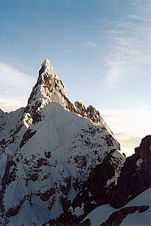
Cayesh is a mountain in the Cordillera Blanca in the Andes of Peru, about 5,721 metres (18,770 ft) high. It is located between Huaraz and Huari provinces in Ancash. Cayesh lies at the head of the Cayesh valley, northwest of Artisa and southeast of Andavite.
Milluacocha is a 5,404-metre-high (17,730 ft) mountain in the Cordillera Blanca range in the Andes of Peru. Other sources claim this mountain has an elevation of 5,480-metre-high (17,979 ft). It is located in Yuracmarca District, Huaylas Province, Ancash. It lies between Santa Cruz in the southeast and Champara in the northwest. Pilanco is located east of it. Los Cedros Creek flows along its southern slopes.

Ulta is a mountain in the Cordillera Blanca in the Andes of Peru, about 5,875 metres (19,275 ft) high. It is located in the region of Ancash.