Related Research Articles

Cuautitlán is a city and municipality in the State of Mexico, just north of the northern tip of the Federal District within the Greater Mexico City urban area. The city has engulfed most of the municipality, making the two synonymous. The name comes from Nahuatl and means 'between the trees.'
The Triqui, or Trique, languages are a family of Oto-Manguean spoken by 30,000 Trique people of the Mexican states of Oaxaca and the state of Baja California in 2007. They are also spoken by 5,000 immigrants to the United States. Triqui languages belong to the Mixtecan branch together with the Mixtec languages and Cuicatec.

The Triqui or Trique are an indigenous people of the western part of the Mexican state of Oaxaca, centered in the municipalities of Juxtlahuaca, Tlaxiaco and Putla. They number around 23,000 according to Ethnologue surveys. The Triqui language is a Mixtecan language of Oto-Manguean genetic affiliation. Trique peoples are known for their distinctive woven huipiles, baskets, and morrales (handbags).

Santa Lucía del Camino is a city and its surrounding municipality located in the central part of the Mexican state of Oaxaca. It lies just 3 km east of the state capital city of Oaxaca, within the Oaxaca metropolitan area. It is part of the Centro District in the Valles Centrales region.
Santa Cruz de Juventino Rosas is a Mexican city located in the central east region of the state of Guanajuato. The municipality has an area of 428.64 square kilometres and is bordered to the north by San Miguel de Allende, to the northeast by Comonfort, to the southeast by Celaya, to the south by Villagrán, and to the west by Salamanca. The municipality had a population of 65,479 inhabitants according to the 2005 census.
Copala may refer to:

Copala Triqui is a Trique language primarily spoken in and around the town of San Juan Copala, Oaxaca, Mexico. A 2007 estimate by SIL International placed the number of Copala Triqui speakers at 25,000.
Putla Villa de Guerrero or simply Putla, is a town and municipality in the State of Oaxaca, Mexico. It is part of Putla District in the west of the Sierra Sur Region.
San Martín Itunyoso is a Trique language town and municipality in Oaxaca in south-western Mexico. The municipality covers an area of 82.93 km². It is part of the Tlaxiaco District in the south of the Mixteca Region.

Zapotitlán Lagunas is a town and one municipality out of 570 that make up the state of Oaxaca in south-western Mexico. The municipality covers an area of 306.418 km². It is part of the Silacayoapam District in the Mixteca Region.
San Sebastián Tecomaxtlahuaca is a town and municipality in Oaxaca in south-western Mexico. The municipality covers an area of 369.99 km² and is part of the Juxtlahuaca District of the Mixteca Region.

Santiago Juxtlahuaca is a town and municipality in Oaxaca in south-western Mexico. It is in the Juxtlahuaca District of the Mixteca Region.
Santos Reyes Tepejillo is a town and municipality in Oaxaca in south-western Mexico. The municipality covers an area of km² and is part of the Juxtlahuaca District of the Mixteca Region.
Ubisort is a paramilitary group in Oaxaca, Mexico affiliated with the Institutional Revolutionary Party (PRI) party.

Alberta "Bety" Cariño Trujillo, a Woman Human Rights Defender, was the director of CACTUS, a community organization in Oaxaca, Mexico. On April 27, 2010, she was killed when paramilitaries ambushed a caravan on its way to the indigenous autonomous community of San Juan Copala. The caravan, including local and international human rights observers, was delivering food to the community which has been under a blockade from paramilitaries allied with the state government. The gunmen also killed Jyri Jaakkola, a Finnish human rights activist, and more than ten people were wounded.
Jyri Antero Jaakkola was a Finnish human rights activist. He was on his way to San Juan Copala, a village of indigenous Trique people that has declared itself autonomous, as a human rights observer when he was shot dead by UBISORT, a paramilitary organization connected to Institutional Revolutionary Party. In the attack Alberta Cariño, an activist for the local organization CACTUS, was also shot dead and more than ten people were wounded.
The Autonomous Municipality of San Juan Copala is an entity made up of Trique Indians who declared their autonomy of the Mexican state in 2006 as a reaction to repression by the Mexican state, especially the Oaxacan government, whose leader Ulises Ruiz was targeted by the APPO movement at the time. The move is inspired by the Zapatista Movement in neighbouring Chiapas. It has since been the target of violent attacks by the local paramilitary groups UBISORT and MULT which are related to the PRI, the party of Ulises Ruiz.

Homún Municipality is one of the 106 municipalities in the Mexican state of Yucatán containing (192.89 km2) of land and located roughly 50 km southeast of the city of Mérida.

Mayapán Municipality is one of the 106 municipalities in the Mexican state of Yucatán containing (103.47 km2) of land and is roughly 95 km southeast of the city of Mérida.
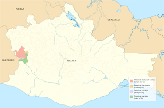
San Juan Copala is home to the Triqui people who live in the Mexican state of Oaxaca. Oaxaca, located in the Southwest of the country, has a population of more than 3.2 million and is home to "16 different ethnic indigenous groups." Triqui is an overarching linguistic group that includes three subgroups: Copala Triqui, Chicahuaxtla Triqui, and San Martín Triqui. The different subgroups are determined by where they live in the mountains: Copala Triqui is found in the lower region of Copala, San Martín Triqui is found in the middle area of San Martín Itunyoso, and Chicahuaxtla is found in the higher region of San Andrés de Chicahuaxtla. There are over 20,000 speakers of Triqui in this region: "15,000…in Copala; 6,000 in San Andrés Chicahuaxtla; 2,000 in San Martín Itunyoso."
References
- ↑ Instituto Nacional de Estadística y Geografía. "Archivo histórico de localidades".
- ↑ López Bárcenas, Francisco: "El municipio autónomo de San Juan Copala". La Jornada, 10 de enero de 2007. Consultada el 27 de enero de 2011.
- ↑ San Juan Copala: crónica de una represión anunciada, Francisco López Bárcenas, La Jornada, Apr 29th, 2010, http://www.jornada.unam.mx/2010/04/29/index.php?article=009a1pol§ion=opinion
- ↑ Paramilitaries Kill Two Human Rights Activists in Oaxaca, Democracy Now!, April 30, 2010 https://www.democracynow.org/2010/4/30/paramilitaries_kill_two_human_rights_activists
Coordinates: 17°11′N97°58′W / 17.183°N 97.967°W
| | This article about a location in the Mexican state of Oaxaca is a stub. You can help Wikipedia by expanding it. |