San Lorenzo is the Italian and Spanish name for Saint Lawrence, the 3rd-century Christian martyr, and may refer to:

San Lorenzo de El Escorial, also known as El Escorial de Arriba, is a town and municipality in the Community of Madrid, Spain, located to the northwest of the region in the southeastern side of the Sierra de Guadarrama, at the foot of Mount Abantos and Las Machotas, 47 kilometres (29 mi) from Madrid. It is head of the eponymous judicial party. The settlement is popularly called El Escorial de Arriba, to differentiate it from the neighbouring village of El Escorial, also known as El Escorial de Abajo.

Cuautitlán Izcalli is a city and one of the 125 municipalities that make up the State of Mexico. Its municipal seat is Cuautitlán Izcalli. It is located in the Valley of Mexico area, and is part of the Metropolitan area of Mexico City. It borders to the north and northwest with Tepotzotlán, to the northeast and to the east with Cuautitlán, to the south with Tlalnepantla de Baz, to the southeast with Tultitlán, to the southwest with Atizapán de Zaragoza and to the west with the municipality of Nicolás Romero.

Oaxaca is a state in Southwest Mexico that is divided into 570 municipalities, more than any other state in Mexico. According to Article 113 of the state's constitution, the municipalities are grouped into 30 judicial and tax districts to facilitate the distribution of the state's revenues. It is the only state in Mexico with this particular judicial and tax district organization. Oaxaca is the tenth most populated state with 4,132,148 inhabitants as of the 2020 Mexican census and the fifth largest by land area spanning 93,757.6 square kilometres (36,200.0 sq mi).

Almoloya de Juárez is a town in the State of Mexico and the seat of the municipality of Almoloya de Juárez. The name Almoloya comes from the Nahuatl, that is properly Almoloyan, composed of: atl, "water"; molo "impersonal voice of moloni, to flow the source" and yan, "place"; that it means "place where flows the water source".

Metepec is a municipality in the State of Mexico in Mexico and is located directly to the east of the state capital, Toluca, at an altitude of 2,635 metres (8,645 ft) above sea level. The center of Mexico City lies some 50 km further to the east. The city of Metepec also form part of the Greater Toluca. The name Metepec comes from Náhuatl meaning hill of the agave plants. However, it is also known in the Matlatzinca language as "Nepinta-Tuhi" meaning 'people of corn land' and in the Otomi language as "Ntaguada".
Ixtlahuaca de Rayón is the municipal seat and 5th largest city in the municipality of Ixtlahuaca north of Toluca in the northwest part of the State of Mexico, in Mexico. The distance between Mexico City and Ixtlahuaca is 32 km. The name Ixthahuaca comes from Náhuatl and means plains without trees. The city and municipality were officially established by decree on November 14, 1816 by the Congress of the State of Mexico.
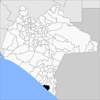
Villa Mazatán (Spanish pronunciation:[ˈβiʝamasaˈtan] is a municipality in the Mexican state of Chiapas in southern Mexico. It has an area of 386.6 km ² and is located in the southwestern Mexican state.
San Lorenzo Albarradas is a town and municipality in Oaxaca in south-western Mexico. The municipality covers an area of 61.24 km². It is part of the Tlacolula District in the east of the Valles Centrales Region.
San Lorenzo Cacaotepec is a town and municipality in Oaxaca in south-western Mexico. The municipality covers an area of 12.76 km2. It is part of the Etla District in the Valles Centrales region. As of 2005, the municipality had a total population of 11,559.
San Lorenzo Cuaunecuiltitla is a town and municipality in Oaxaca in south-western Mexico. The municipality covers an area of 12.76 km². It is part of the Teotitlán District in the north of the Cañada Region.
San Lorenzo Texmelucan is a town and municipality in Oaxaca in south-western Mexico. The municipality covers an area of 303.65 km2. It is part of the Sola de Vega District in the Sierra Sur Region.
San Lorenzo Victoria is a town and municipality in Oaxaca in south-western Mexico. The municipality covers an area of 30.62 km². It is part of the Silacayoapam District in the Mixteca Region.
Yanga Municipality is a municipality located in the southern area of the Mexican state of Veracruz, about 80 km from the state capital of Xalapa. It was formerly known as San Lorenzo de los Negros or San Lorenzo de Cerralvo. In 1932 it was renamed after Gaspar Yanga, the cimarron leader who in 1609 resisted attack by Spanish forces trying to regain control of the area.
Otumba is a municipality in the State of Mexico in Mexico. The municipal seat and largest town is Otumba de Gómez Farías. The municipality of Otumba has a land area of some 143.42 square kilometres (55 sq mi), and a population recorded in the intermedial 2005 census, the Conteo de Población y Vivienda, of 29,873.
Huejotzingo ( is a small city and municipality located just northwest of the city of Puebla, in central Mexico. The settlement's history dates back to the pre-Hispanic period, when it was a dominion, with its capital a short distance from where the modern settlement is today. Modern Huejotzingo is located where a Franciscan monastery was founded in 1525, and in 1529, the monks moved the indigenous population of Huejotzingo to live around the monastery. Today, Huejotzingo is known for the production of alcoholic apple cider and fruit preserves, as well as its annual carnival. This carnival is distinct as it centers on the re-enactment of several historical and legendary events related to the area. The largest of these is related to the Battle of Puebla, with about 2, 000 residents representing French and Mexican forces that engage in mock battles over four days.

San Lorenzo Marine Archipelago National Park is a national park of Mexico located on San Lorenzo Island part of an archipelago in the Gulf of California off the eastern coast of Baja California. The San Lorenzo Archipelago is considered one of the most important ecological areas of the Gulf of California. The Island and surrounding areas are part of a rich ecosystem comprised by a grand variety of flora and marine fauna. This area is protected by the Mexican federal government Norma Oficial Mexicana NOM-059-SEMARNAT-2001 because of its importance as a habitat for several endangered species. The Archipelago is part of the municipality of Mexicali, Baja California. The island is located southeast of the city separated by the Salsipuedes Channel.

Municipality of Culiacán is a municipality in the Mexican state of Sinaloa in northwestern Mexico.

Silacayoápam District is located in the northwest of the Mixteca Region of the State of Oaxaca, Mexico.
Irimbo is a municipality located in the southeastern part of the Mexican state of Michoacán. The municipality has an area of 125.54 square kilometers.
