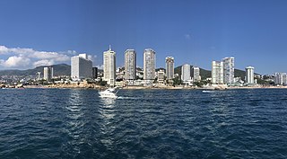
Acapulco de Juárez, commonly called Acapulco, is a city and major seaport in the state of Guerrero on the Pacific Coast of Mexico, 380 kilometres (240 mi) south of Mexico City. Acapulco is located on a deep, semicircular bay and has been a port since the early colonial period of Mexico's history. It is a port of call for shipping and cruise lines running between Panama and San Francisco, California, United States. The city of Acapulco is the largest in the state, far larger than the state capital Chilpancingo. Acapulco is also Mexico's largest beach and balneario resort city. Acapulco de Juárez is the municipal seat of the municipality of Acapulco.

Guerrero, officially the Free and Sovereign State of Guerrero, is one of the 32 states that comprise the 32 Federal Entities of Mexico in Mexico. It is divided in 81 municipalities. The state has a population of about 3.5 million people. It is located in southwest Mexico and is bordered by the states of Michoacán to the north and west, the State of Mexico and Morelos to the north, Puebla to the northeast and Oaxaca to the east. In addition to the capital city, Chilpancingo and the largest city Acapulco, other cities in Guerrero include Petatlán, Ciudad Altamirano, Taxco, Iguala, Ixtapa, and Zihuatanejo. Today, it is home to a number of indigenous communities, including the Nahuas, Mixtecs, Tlapanecs, Amuzgos, and formerly Cuitlatecs. It is also home to communities of Afro-Mexicans in the Costa Chica region.

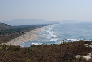
Zihuatanejo, and/or Ixtapa-Zihuatanejo, is the fourth-largest city in the Mexican state of Guerrero. It was known by 18th-century English mariners as Chequetan and/or Seguataneo. Politically the city belongs to the municipality of Zihuatanejo de Azueta in the western part of Guerrero, but both are commonly referred to as Zihuatanejo. It is on the Pacific Coast, about 240 km northwest of Acapulco and 411 km further south in latitude than Honolulu, Hawaii. Zihuatanejo belongs to a section of the Mexican Pacific Coast known as the Costa Grande. This town has been developed as a tourist attraction along with the modern tourist resort of Ixtapa, 5 km (3.1 mi) away. However, Zihuatanejo has kept its traditional town feel. The town is located on a well-protected bay which is popular with private boat owners during the winter months.
Galeana is a Mexican last name. Several municipalities in Mexico are named Galeana as a homage to Hermenegildo Galeana, a hero of the War of Independence.
Putla Villa de Guerrero or simply Putla, is a town and municipality in the State of Oaxaca, Mexico. It is part of Putla District in the west of the Sierra Sur Region.

The Costa Chica of Guerrero is an area along the south coast of the state of Guerrero, Mexico, extending from just south of Acapulco to the Oaxaca border. Geographically, it consists of part of the Sierra Madre del Sur, a strip of rolling hills that lowers to coastal plains to the Pacific Ocean. Various rivers here form large estuaries and lagoons that host various species of commercial fish.
Costa Grande of Guerrero is a sociopolitical region located in the Mexican state of Guerrero, along the Pacific Coast. It makes up 325 km (202 mi) of Guerrero's approximately 500 km (311 mi) coastline, extending from the Michoacán border to the Acapulco area, wedged between the Sierra Madre del Sur and the Pacific Ocean. Acapulco is often considered part of the Costa Grande; however, the government of the state classifies the area around the city as a separate region. The Costa Grande roughly correlates to the Cihuatlán province of the Aztec Empire, which was conquered between 1497 and 1504. Before then, much of the area belonged to a dominion under the control of the Cuitlatecs, but efforts by both the Purépecha Empire and Aztec Empire to expand into this area in the 15th century brought this to an end. Before the colonial period, the area had always been sparsely populated with widely dispersed settlements. The arrival of the Aztecs caused many to flee and the later arrival of the Spanish had the same effect. For this reason, there are few archeological remains; however, recent work especially at La Soledad de Maciel has indicated that the cultures here are more important than previously thought. Today, the area economically is heavily dependent on agriculture, livestock, fishing and forestry, with only Zihuatanejo and Ixtapa with significantly developed infrastructure for tourism. The rest of the coast has been developed spottily, despite some government efforts to promote the area.

Petatlán is a city in Petatlán Municipality located along the Pacific Coast of the state of Guerrero in Mexico. It is part of the Costa Grande region between Zihuatanejo and Acapulco. The city is known for the Sanctuary of the Padre Jesús de Petatlán, a 17th-century image of Christ that is claimed to have performed religious miracles. The city is the seat of a large municipality, which faces the Pacific Ocean to the south and is bounded by the Sierra Madre del Sur to the north. It contains the La Soledad de Maciel archeological site. The area's recent history has been marked by violence related to the drug trade and to struggles between business and local farmers and environmental groups. St. Peter, Minnesota is a sister city of Petatlán.

San Juan Cacahuatepec is a city in the Mexican state of Oaxaca, near the border with Guerrero. It is located in the Jamiltepec District in the west of the Costa Region. Its population in 1990, according to The Columbia Gazetteer of North America, was 3,116; in 2006, it was about 5,000. Along with San Pedro Amusgos, it is a heavy center of population for the indigenous Amuzgo. The name Cacahuatepec is Nahuatl, translating "Place of Cacao-bean mountain".
Federal Highway 95 connects Mexico City to Acapulco, Guerrero. The Autopista del Sol is a tolled alternative, which bypasses several towns of the state of Guerrero, including the city Iguala, and thus reduces transit time between Acapulco from Mexico city from 8 hours to almost 3.5 hours.
Federal Highway 200, also known as Carretera Pacífico, is a federal highway of Mexico. The Carretera Pacífico is the main leg of the Pacific Coastal Highway within Mexico and travels along the Pacific Coast from Federal Highway 15 in Tepic, Nayarit, in the north to the Guatemala–Mexico border at Talismán, Chiapas, in the south. Upon entering Guatemala, the highway continues as Central American Highway 2 (CA-2).

Atoyac de Álvarez is one of the 81 municipalities of Guerrero, in southern Mexico. The municipal seat lies at Atoyac de Álvarez. The municipality covers an area of 1,638.4 km2 (632.6 sq mi).

San Luis Acatlán is one of the 81 municipalities of Guerrero, in south-western Mexico. The municipal seat lies at San Luis Acatlán. The municipality covers an area of 704.4 km².

Julia López is a Mexican painter whose works depict her childhood home in the Costa Chica region of Guerrero state. She was born in a small farming village but left early for Acapulco and Mexico City to find a better life. In the capital, she was hired as a model for artists at the Escuela Nacional de Pintura, Escultura y Grabado "La Esmeralda" and as such became part of the circle of notable artists of that time. Their influenced encouraged her to draw and paint, with Carlos Orozco Romero discouraging her from formal instruction as to not destroy her style. She began exhibiting in 1958 and since then has exhibited individually and collectively in Mexico, the United States and Europe. Her work has been recognized with awards and membership in the Salón de la Plástica Mexicana.
Same-sex marriage has been legal in Guerrero since 31 December 2022. After the Supreme Court of Justice of the Nation ruled that same-sex marriage bans are unconstitutional nationwide under the Constitution of Mexico on 12 June 2015, officials in Guerrero began announcing plans for a collective group wedding. Governor Rogelio Ortega Martínez submitted a same-sex marriage bill to Congress on 7 July 2015 and instructed civil registrars to issue marriage licenses to same-sex couples. Legislators lamented they would have preferred to have the bill passed before marriages took place, but given the time line presented, it was unlikely. On 10 July 2015, twenty same-sex couples were married by Ortega Martínez in Acapulco.
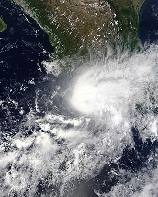
Hurricane Marty was a tropical cyclone that produced heavy rains and flooding in several states in Southwestern and Western Mexico. The twentieth named storm and twelfth hurricane of the annual hurricane season, Marty developed from a tropical wave on September 26, 2015, to the southwest of Acapulco, Guerrero, in Mexico. Initially a tropical depression, the system strengthened into a tropical storm early on the following day. Due to favorable atmospheric conditions, Marty continued to intensify, but wind shear sharply increased as the storm approached a large mid- to upper-level trough. Despite this, the cyclone deepened further, becoming a hurricane on September 28 and peaking with sustained winds of 80 mph (130 km/h) shortly thereafter. Wind shear quickly took its toll on the hurricane, weakening it to a tropical storm early on September 29. About 24 hours later, Marty degenerated into a post-tropical low-pressure area offshore Guerrero. The low further degenerated into a trough later on September 30, and eventually dissipated on October 4.
Federal Highway 200D is the toll highways paralleling Fed. 200, and has two separate improved segments of designated roadway. Fed200D in Colima funnels traffic from Manzanillo toward Fed. 110 to the city of Colima; the segment in Guerrero serves as a bypass of Tecpan.

Tropical Storm Carlotta was a moderately strong tropical cyclone that caused flooding in several states in southwestern and central Mexico. Carlotta, the third named storm of the 2018 Pacific hurricane season, formed as the result of a breakdown in the Intertropical Convergence Zone. On June 12, a broad area of low pressure developed several hundred miles south of Mexico and strengthened into a tropical storm by June 15. The next day, the system stalled unexpectedly within a favorable environment, which led to more intensification than originally anticipated. Early on June 17, Carlotta reached peak intensity with maximum sustained winds of 65 mph (100 km/h) and a minimum central pressure of 997 mbar while located only 30 mi (50 km) south-southeast of Acapulco. The system then began to interact with land and experience wind shear, which resulted in the storm weakening to tropical depression status later in the day. The system weakened to a remnant low early on June 19 and dissipated several hours later.

The Mexican South Pacific Coast mangroves ecoregion covers the mangrove sites along the coast of the Pacific Ocean coast of Mexico, across the states of Michoacán, Guerrero, and Oaxaca. These mangrove forests are mostly around lagoons, typically those fed by rivers from the interior in the Sierra Madre del Sur Mountains. The ecoregion is small: collectively, it covers only 1,295 km2.
A moment magnitude Mw 7.0 or 7.1 earthquake occurred near the city of Acapulco in the Mexican state of Guerrero at on 7 September with an estimated intensity of VIII (Severe) on the MMI scale. The earthquake killed 13 people and injured at least 23 others. At least 1.6 million people in Mexico were affected by the earthquake which resulted in localized severe damage. The earthquake occurred on the anniversary of the 2017 Chiapas earthquake which measured Mw 8.2. It was also the largest earthquake in Mexico since the 2020 Oaxaca earthquake.
