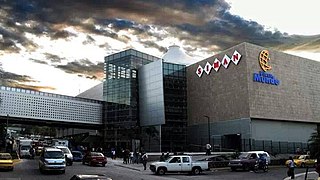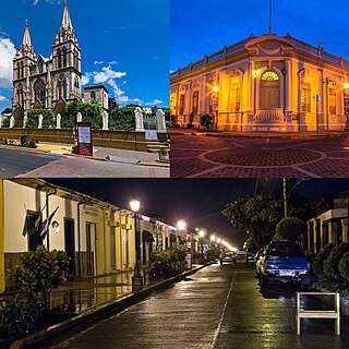
San Salvador is the capital and the largest city of El Salvador and its eponymous department. It is the country's political, cultural, educational and financial center. The Metropolitan Area of San Salvador, which comprises the capital itself and 13 of its municipalities, has a population of 2,404,097. The urban area of San Salvador has a population of 1,600,000 inhabitants.

Santa Ana is the second largest city in El Salvador, after the capital of San Salvador. It is located 64 kilometers northwest of San Salvador, the capital city. Santa Ana has approximately 374,830 (2017)) inhabitants and serves both as the capital of the department of Santa Ana and as the municipal seat for the surrounding municipality of the same name. For its administration the municipality is divided into 35 colonias (neighborhoods) and 318 small villages.
Salvador, meaning "salvation" in Catalan, Spanish, and Portuguese may refer to:

Acajete Municipality is a municipality located in the central zone in the state of Veracruz, about 20 km from state capital Xalapa. It has a surface of 90.48 km2. It is located at 19°58′N97°00′W. In the middle of 1586 this village was formed, on one of the adjoining old men of Tlacolulan's dominion. The decree N ° 64 of November 3, 1893, extinguished the municipality of La Hoya, annexing its territory to San Salvador Acajete. On November 5, 1932, the municipal head-board San Salvador Acajete changes the name to Acajete.

San Salvador is a department of El Salvador in the west central part of the country. The capital is San Salvador, which is also the national capital. The department has North of the Rio Lempa Valley, the "Valle de las Hamacas" and a section of Lake Ilopango. Some of the department's cities that are densely populated are: San Salvador, Ciudad Delgado, Mejicanos, Soyapango, Panchimalco and Apopa. The department covers an area of 886.2 square kilometres (342.2 sq mi) and the last census count in 2017 reported 2,404,097 people. It was classified as a department on June 12, 1824. During the time of the colony, the department was the San Salvador Party, from where territory was taken to make the departments of Chalatenago, La Libertad, Cuscatlán and La Paz. This department produces beans, coffee, sugar cane, etc. for agriculture, on the other hand San Salvador Department holds many headquarters for banking companies in El Salvador and Central America, and for many communication services, also the headquarters of the electric companies are located in the San Salvador Department, last years these companies took a step and started exporting electricity to all Central America. The current mayor of the department is Ernesto Muyshondt (2015-2019)

El Salvador, officially the City of El Salvador, is a 6th class component city in the province of Misamis Oriental, Philippines. According to the 2020 census, it has a population of 58,771 people.

Cololaca is a municipality in the Honduran department of Lempira.

Ocotepeque is a municipality in the Honduran department of Ocotepeque. The town of Nueva Ocotepeque is the municipal seat and the capital of the department.

Apopa is a municipality in the San Salvador department of El Salvador. Probably the seventh biggest city in El Salvador with a little more than 150,000 people, the city has now collided with Soyapango and San Salvador, making it part of the Great San Salvador Metro.

Soyapango is a municipality in the San Salvador department of El Salvador. Soyapango is a commercial center. The municipality is the third most populated area in the country, with 290,412 inhabitants. Soyapango is a satellite city of San Salvador and it is the main thoroughfare between San Salvador and the eastern part of the country, and nearly 70,000 vehicles travel through it every day. The nickname for this satellite city is Soya. The city is infamously and notoriously known for being the most dangerous city of the Central America region, and also for being a breeding ground for the Mara gangs and the place where gang members first arrive after being deported to El Salvador from Los Angeles, reason why these two locations evoke a similar resemblance to each other.

Chapeltique is a municipality in the San Miguel department of El Salvador.

Uluazapa is a municipality in the San Miguel department of El Salvador. The town is located approximately 30 minutes from San Miguel and is known for its musical atmosphere. Many refer to it as a "cradle of musicians" for its emphasis on musical education. The name "Uluazapa" stands for "Stony place of the Ulúas" in Nauathl, which were Indian tribes that inhabited the area pre-Columbian time. The municipality is made up of surrounding cantons, hamlets, and neighborhoods. The Uluazapa Central Park is located in the middle of the town, next to the colonial "San Pedro Apostal" church and the municipal hall. Surrounding the park are local shop, restaurants, and businesses. It also has a large sport center equipped with a soccer field and basketball courts. The town has a population of 3,351 Inhabitants.

Antiguo Cuscatlán(colloquially known as Antiguo) is a municipality in the La Libertad department of El Salvador, and its eastern tip lays in San Salvador Department part of the Metropolitan Area of San Salvador, southwest of San Salvador and southeast of Santa Tecla. The population was 48,027 at the 2010 census. Antiguo Cuscatlán can be translated as Old Jeweled City: Antiguo means ancient or old in Spanish, and Cuscatlán means jeweled city in Nahuat. The city used to be the capital of the Pipil or Cuzcatecs, before the Spanish conquest of the New World.

Nuevo Cuscatlán is a municipality in the La Libertad department of El Salvador. It is situated between the cities of Antiguo Cuscatlán and Santa Tecla, just a couple of minutes away from El Salvador's capital, San Salvador. It is located southeast of Santa Tecla. During the 2012 municipal elections, Nayib Bukele, a young businessman, from the FMLN party was elected as mayor.

La Palma is a municipality in the Chalatenango department of El Salvador. The municipality, located in a mountainous area of the country, covers an area of 135.60 km² and as of 2006 had an approximate population of 24,000.

Suchitoto is a municipality in the Department of Cuscatlán, El Salvador that has seen continuous human habitation long before Spanish colonization. Within its municipal territory, Suchitoto holds the site of the original founding of the Villa of San Salvador in 1528 that existed for a short time before the site was abandoned. In more recent times, the municipality has prospered even after the severe effects of civil war in El Salvador that lasted between 1980 - 1992 and saw the population of Suchitoto decrease from 34,101 people in 1971 to 13,850 by 1992. It has become an important tourist destination partly due to its well conserved colonial architecture and cobblestone roads that provide a sense of Spanish colonial living. This rise in tourism has attracted service sector businesses to open up in the small city including hostels, restaurants, and picturesque cafes. As a result of tourism, many arts and cultural spaces have opened up in Suchitoto that are also providing positive alternative opportunities for youth in the community. According to the 2007 Official Census, the small city has a population of 24,786 people with 7,654 people living in the urban area and 17,132 people living in the rural communities.

Santa Tecla is a municipality in the La Libertad department of El Salvador. It is the capital of the department of La Libertad.

The municipalities or municipios of El Salvador correspond to the second level administrative division in the Republic of El Salvador which divide its departments. El Salvador contains 262 municipalities.

San Salvador is a town and one of the 84 municipalities of Hidalgo, in central-eastern Mexico. The municipality covers an area of 200.4 km².

San Salvador Huixcolotla is a town and municipality in Puebla in southeastern Mexico that may be best known as the birthplace of papel picado. San Salvador is Spanish for "Holy Savior" and Huixcolotla is Nahuatl for "place of the curved spines".


