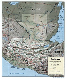
Guatemala is mountainous, except for the south coastal area and the vast northern lowlands of Petén department. The country is located in Central America and bounded to the north and west by Mexico, to the northeast by Belize and by the Gulf of Honduras, to the east by Honduras, to the southeast by El Salvador, and to the south by the Pacific Ocean. Two mountain chains enter Guatemala from west to east, dividing the country into three major regions: the highlands, where the mountains are located; the Pacific coast, south of the mountains; and the limestone plateau of the Petén region, north of the mountains. These areas vary in climate, elevation, and landscape, providing dramatic contrasts between hot and humid tropical lowlands and highland peaks and valleys.
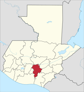
Guatemala Department is one of the 22 departments of Guatemala. The capital is Guatemala City, which also serves as the national capital. The department consists of Guatemala City and several of its suburbs.

Jalapa is a department of Guatemala, in the south east-of the republic. The capital is the city of Jalapa.

San Marcos is a department in northwestern Guatemala, on the Pacific Ocean and along the western Guatemala-Mexico border.

This is a list of the extreme points of North America: the points that are highest and lowest, and farther north, south, east or west than any other location on the continent. Some of these points are debatable, given the varying definitions of North America.
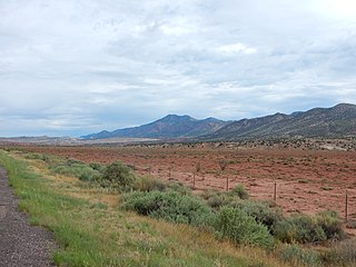
The Sierra Nacimiento, or Nacimiento Mountains, are a mountain range in the northwestern part of the U.S. state of New Mexico. They are just west of the more prominent Jemez Mountains near the town of Cuba, and are separated from them by the Río Guadalupe and the Río de Las Vacas. This article will consider them as a unit together with the San Pedro Mountains, which are a smaller range contiguous with the Sierra Nacimiento on the north, and which are also part of the Nacimiento Uplift and lie at the edge of the greater San Juan Basin, which sits atop the Colorado Plateau. The combined range runs almost due north-south with a length of about 40 mi (65 km). The highest point in the combined range is the high point of the San Pedro Peaks, known unofficially as San Pedro Peak, 10,605 ft.
Acatenango is a town and municipality in the Chimaltenango department of Guatemala. It is in this municipality that the Acatenango volcano is located. The town is in the valley of the Cocoyá River.
Yepocapa, also known as San Pedro Yepocapa, is a town with a population of 17,021, and a municipality in the Chimaltenango department of Guatemala. It is located at the base of Volcán de Fuego, which has destroyed the town several times, most recently on 14 October 1974.
San Pedro Ayampuc is a town, with a population of 48,727, and a municipality in the Guatemala department of Guatemala. As of 2011 the current mayor is Eduardo Avalos Figueroa.

The Suchiate River is a river that marks the southwesternmost part of the border between Mexico and Guatemala. From its sources on the southern slopes of the Tacaná volcano in the Sierra Madre range of Guatemala, the river flows in a south-southwesterly direction to the border with Mexico at Unión Juárez, past the border towns Talismán and El Carmen, and then Ciudad Tecún Umán and Ciudad Hidalgo (Chiapas) further downstream, where the Puente Rodolfo Robles and a railway bridge cross the river, and on to the Pacific Ocean. Its name comes from the Nahuatl name Xochiatl meaning "flower-water".
The Petén Basin is a geographical subregion of Mesoamerica, primarily located in northern Guatemala within the Department of El Petén, and into Campeche state in southeastern Mexico.

The Pasión River is a river located in the northern lowlands region of Guatemala. The river is fed by a number of upstream tributaries whose sources lie in the hills of Alta Verapaz. These flow in a general northerly direction to form the Pasión, which then tends westwards to meet up with the Salinas River at 16°28′52″N90°32′39″W. At this confluence the greater Usumacinta River is formed, which runs northward to its eventual outlet in the Gulf of Mexico. The Pasión River's principal tributaries are the San Juan River, the Machaquila River, and the Cancuén River.

The Xalbal River is a river of Guatemala. Its sources are in the Sierra de los Cuchumatanes in the department of El Quiché, where the river is called Río Xaclbal or Río Chajul. The Xaclbal river flows northwards down the tropical lowlands of Ixcan where it is called Río Xalbal, and crosses the border with Mexico, where it joins the Lacantún River, a tributary of the Usumacinta river. The Guatemalan part of Xaclbal river basin covers an area of 1,366 square kilometres (527 sq mi).
The Salinas is a river in Guatemala. The river is called Río Negro from its sources in the highlands of Huehuetenango and El Quiché until it reaches the Chixoy hydroelectric dam, where the Río Salama and Rio Carchela converge with the Río Negro. After the Chixoy dam, the river is called Río Chixoy and flows northwards through Alta Verapaz until it reaches the border with Mexico. From there on it continues along the border for 113 kilometres (70 mi) as the Salinas river until it finally converges with the Río de la Pasión to form the Usumacinta river which flows into the Gulf of Mexico.
The Chixoy River or Río Chixoy is a river in Guatemala. The river is called Río Negro from its sources in the highlands of Huehuetenango and El Quiché until it reaches the Chixoy hydroelectric dam, where the Río Salamá and Rio Carchela converge with the Río Negro. After the Chixoy dam, the river is called Río Chixoy and flows northwards, marking the departmental limits between Alta Verapaz and El Quiché, until it reaches the border with Mexico. From there on it continues along the border for another 113 kilometres (70 mi) as the Salinas river until it finally converges with the Río la Pasión to form the Usumacinta river which flows into the Gulf of Mexico.

The Lempa River is a 422-kilometre (262 mi) long river in Central America.
Poxte is a river and valley of the Maya Mountains in Guatemala. The valley is noted for numerous Maya sites such as Ixtutz and the Petén Caves. The river is located on the southwest of the Dolores plateau and northwest of Poptún, in the Guatemalan department of Petén. The source of the river is on the same plateau, near the villages of Boca del Monte and Santo Domingo. The river flows westwards through the hamlet of Poxte, it then disappears amongst the karst topography and resumes its course 7 kilometres (4.3 mi) to the west. It continues westwards into the San Juan River, which is a tributary of the Machaquila River. The Machaquila River feeds into the Pasión River, which flows into the Usumacinta River and into the Gulf of Mexico. The upper reaches of the Poxte River shares its drainage with the Mopan River, which flows eastwards into the Caribbean Sea.