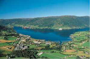
The Hardangerfjord is the fourth longest fjord in the world, and the second longest fjord in Norway. It is located in Hordaland county in the Hardanger region. The fjord stretches 179 kilometres (111 mi) from the Atlantic Ocean into the mountainous interior of Norway along the Hardangervidda plateau. The innermost point of the fjord reaches the town of Odda.

The Varangerfjord is the easternmost fjord in Norway, north of Finland. The fjord is located in Finnmark county between the Varanger Peninsula and the mainland of Norway. The fjord flows through the municipalities of Vardø, Vadsø, Nesseby, and Sør-Varanger. The fjord is approximately 100 kilometres (62 mi) long, emptying into the Barents Sea. In a strict sense, it is a false fjord, since it does not have the hallmarks of a fjord carved by glaciers.

Stjernøya is an island in western Finnmark county, Norway. The 248.1-square-kilometre (95.8 sq mi) island sits at the mouth of the Altafjorden on the south side of the Sørøysundet strait. It is divided among the municipalities of Loppa, Hasvik, and Alta. The highest point on the island is the 960-metre (3,150 ft) tall mountain Kjerringfjordfjellet. One of the larger fjords on the island is the Sørfjorden. There were 80 residents on the mountainous island in 2012. The main population area is at the village of Store Kvalfjord on the northeastern side of the island. On the southern part of the island there is a large nepheline syenite mine at Lillebukt. The island is separated from the mainland by the strait of Stjernsundet.

Bjørnafjorden is a fjord in Hordaland county, Norway. It runs through the municipalities of Austevoll, Fusa, Os, and Tysnes. The large island of Tysnesøya lie along the south side of the Bjørnafjorden and the Bergen Peninsula and the mainland lie along the north and east sides of the fjord. The Fusafjorden split off from the main fjord on the north side by the village of Osøyro. The 30-kilometre (19 mi) fjord is about 10 kilometres (6.2 mi) wide and its maximum depth is 583 metres (1,913 ft) below sea level.

Nordgulen is a fjord in Bremanger Municipality in Sogn og Fjordane county, Norway. It is a branch off the main Gulen fjord. The length of the fjord is about 9 kilometres (5.6 mi). The river Svelgen is one of the primary inflows into the Nordgulen fjord. The village of Svelgen is located at the end of the Nordgulen fjord. There are settlements all around the fjord, and roads along the coast around the entire fjord.
Frøysjøen is a fjord in Bremanger Municipality in Sogn og Fjordane county, Norway. The fjord is about 25 kilometres (16 mi) long and between 2 to 4 kilometres wide. The fjord runs on a northeast-southwest axis between the mainland of Norway and the islands of Bremangerlandet and Frøya.
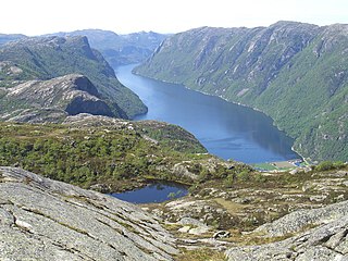
Frafjorden is a fjord in the municipalities Gjesdal and Forsand in Rogaland county, Norway. The 6-kilometre (3.7 mi) fjord is the innermost branch of the Høgsfjorden. The Frafjorden has steep sides with no habitation along its shores, except for the village of Frafjord at the innermost part of the fjord. The village and the surrounding Frafjorddalen farming valley stretches about 5 kilometres (3.1 mi) east of the fjord and the whole area has about 100 residents. There are also many holiday cottages on top of the high mountain located south of the village of Frafjord. The village of Dirdal is located at the mouth of the Frafjorden.

Vindafjorden is a fjord in Rogaland county, Norway. The 30-kilometre (19 mi) long fjord is a northern branch off of the main Boknafjorden. The fjord marks the municipal boundaries between Vindafjord, Suldal, and Tysvær. The fjord initially runs from the very narrow Ropeid isthmus to the west and near the village of Vikadal, the fjord heads to the south before emptying into the Boknafjorden near the village of Nedstrand. There are two smaller fjords which branch off of the Vindafjorden. They are the Sandeidfjorden and the Yrkjefjorden. The deepest part of the fjord reaches about 580 metres (1,900 ft) below sea level, just off the shore from Imsland Church.

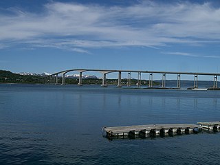
Erfjorden is a fjord in the municipalities Suldal and Hjelmeland in Rogaland county, Norway. The 16-kilometre (9.9 mi) long fjord begins at the small village of Tysse in Suldal and heads south past the village of Hålandsosen before making a sharp turn to the west before emptying into the larger Nedstrandsfjorden. The Erfjord Bridge crosses the fjord, just north of Hålandsosen. The innermost part of the fjord is sometimes referred to as the Tyssefjorden.

Mefjorden is a fjord in Berg Municipality in Troms county, Norway. The 16-kilometre (9.9 mi) long fjord cuts into the large island of Senja from northwest. The villages of Mefjordvær and Senjahopen are located at the southern side of the fjord, and at the innermost point in the fjord is the village of Mefjordbotn.
Gisundet is a strait in Lenvik Municipality in Troms county, Norway. The 35-kilometre (22 mi) long strait separates the island of Senja from the mainland. The strait flows into the Malangen fjord in the north and into the Finnfjorden in the south. The strait is crossed by the Gisund Bridge which connects the village of Silsand on the island to the town of Finnsnes on the mainland.

Salangen (Norwegian) or Siellakvuotna (Northern Sami) is a fjord in Salangen Municipality in Troms county, Norway. The 18-kilometre (11 mi) fjord flows to the northeast from the Astafjorden and then turns to the southeast until it reaches the village of Sjøvegan at the head of the fjord. The innermost part of the fjord is also named the Sagfjorden.

Salangsverket is a village and industrial site in Salangen Municipality in Troms, Norway. It was founded to support mining operations in the early 1900s, and is located at the northern shore of the Salangen fjord, about 6 kilometres (3.7 mi) northwest of the village of Sjøvegan.

Topdalsfjorden or Tofdalsfjorden is a fjord in the municipality of Kristiansand in Vest-Agder county, Norway. The 12-kilometre (7.5 mi) long fjord runs from the village of Ålefjær south to the city centre of Kristiansand. The river Topdalselva empties into the fjord at the eastern side just south of the Kristiansand Airport, Kjevik. The European route E18 highway crosses the fjord on the Varodd Bridge.

Verrasundet is a fjord in Trøndelag county, Norway. The 22-kilometre (14 mi) long fjord branches off of the northern part of the vast Trondheimsfjorden in the municipalities of Verran and Inderøy. It extends from Beitstadfjorden to the village of Verrabotn. The fjord is a maximum of 2 kilometres (1.2 mi) wide, but at Trongsundet, the fjord is barely 200 metres (660 ft) wide.
Børgin or Borgenfjorden is a fjord branch in the eastern part of Trondheimsfjorden in the municipalities of Steinkjer and Inderøy in Trøndelag county, Norway. The 10-kilometre (6.2 mi) long fjord is about 1 to 3 kilometres wide, although the mouth of the fjord is only 100 metres (330 ft) wide. The mouth of the fjord is by the village of Straumen and there is a bridge across the fjord at its narrowest point.

Vanylvsfjorden is a fjord in western Norway, on the border of Sogn og Fjordane and Møre og Romsdal counties. The 30-kilometre (19 mi) long fjord runs between the mainland of Vanylven Municipality and the Stad peninsula of Selje Municipality, with the islands of Sande Municipality lying in the mouth of the fjord. The inner part of the fjord branches into the Syltefjorden and Kjødepollen. The deepest part of the fjord reaches about 252 metres (827 ft) below sea level, just northeast of Borgundvåg.

Sandeid is a former municipality in Rogaland county, Norway. The 66-square-kilometre (25 sq mi) municipality existed from 1923 until its dissolution in 1965. It was located at the northern end of the Sandeidfjorden in what is now part of the municipality of Vindafjord. The administrative centre of the municipality was the village of Sandeid where Sandeid Church is located.

The Eid Fjord is the innermost part of the Hardanger Fjord in Norway. It extends 29 kilometers (18 mi) eastwards from the Utne Fjord and Sørfjorden. The Eid Fjord lies in the municipalities of Ullensvang, Ulvik, and Eidfjord in Hordaland county.