
Swansea is a coastal city and the second-largest city of Wales. It forms a principal area, officially known as the City and County of Swansea.
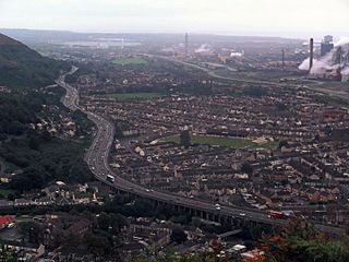
Port Talbot is a town and community in the county borough of Neath Port Talbot, Wales, situated on the east side of Swansea Bay, approximately eight miles from Swansea. The Port Talbot Steelworks covers a large area of land which dominates the south east of the town and is one of the biggest steelworks in the world but has been under threat of closure since the 1980s. The population was 37,276 in 2011.

Normanton is an inner city suburb and ward of the city of Derby in Derbyshire, England, situated approximately 2 miles (3.2 km) south of the city centre. Neighbouring suburbs include Littleover, Pear Tree, Rose Hill and Sunny Hill. The original village of Normanton-by-Derby, which now forms the southern part of the suburb, dates back to the medieval period. As the Normanton area became rapidly urbanised in the 19th century, the New Normanton area to the north was developed for housing, linking the old village to Derby, into which it was eventually absorbed. The area is characterised by high density late 19th century terraced housing in New Normanton and mid-20th century housing estates elsewhere, and has the most ethnically diverse population in Derby. The Normanton ward had a population of 17,071 in 2011.

The Swansea and Mumbles Railway was the venue for the world's first passenger horsecar railway service, located in Swansea, Wales, United Kingdom.
Oystermouth is a village and electoral ward in the district of Mumbles, Swansea, Wales. It is part of the Mumbles community.

Headington is an eastern suburb of Oxford, England. It is at the top of Headington Hill overlooking the city in the Thames valley below, and bordering Marston to the north-west, Cowley to the south, and Barton and Risinghurst to the east. The life of the large residential area is centred upon London Road, the main road between London and Oxford.
Brynmill is a suburb of the City and County of Swansea, Wales, UK. It lies about two miles (3 km) to the west of Swansea city centre. It is a residential area forming the southern part of the Uplands electoral ward. As it is close to Swansea University, many students choose to rent rooms here during term time. Aside from the student population, this is a fairly middle-class area.
Morriston is a community in the City and County of Swansea, Wales and falls within the Morriston ward. It is the largest community in Swansea county.
Blackpill is a suburban area of Swansea, Wales, beside Swansea Bay, about 3 miles (4.8 km) southwest of the city centre.

The Maritime Quarter is a residential area of Swansea, Wales, UK located immediately south of the city centre shopping core. It falls within Swansea's Castle ward. The area is bounded by Brynmill to the west, Swansea Bay to the South, the River Tawe to the east and the A4067 to the north.

Mayhill is a district of Swansea, Wales, at the top of a steep hill of the same name just north west of the city centre, partly separated from Townhill to the west.
Swansea city centre in Swansea, Wales, contains the main shopping, leisure and nightlife district in Swansea. The city centre covers much of the Castle ward including the area around Oxford Street, Castle Square, and the Quadrant Shopping Centre; Alexandra Road, High Street, Wind Street and the Castle; Parc Tawe; and the Maritime Quarter extending down to the seafront.

The Vetch Field was a football stadium in Swansea, Wales. It was used for football matches and was the home ground of Swansea City until the club moved to the newly built Liberty Stadium in 2005. Opened in 1912, the ground held around 12,000 at the time of its closure, but upwards of 30,000 at its peak.
Sandfields is a mainly residential district of Port Talbot, Wales. The area is located in South Wales on a narrow coastal plain between Mynydd Dinas and the sea. The M4 motorway, A48 trunk road and South Wales Main Line run nearby. The area includes a council estate, industrial areas and a seaside resort at Aberavon Beach.
The suburban district of Sketty is about 2 miles (3.2 km) west of the Swansea city centre on Gower Road. It falls within the Sketty council ward of Swansea. It is also a community.

Landore is a district and community in Swansea, Wales. The district falls in the Landore council ward. A mainly residential area, it is located about 2.5 miles north of Swansea city centre. The north-easterly part of Landore is known as Morfa. There have been a number of new developments in the 21st century, such as the Liberty Stadium, now the Swansea.com Stadium, and the Morfa Shopping Park, which opened in 2005. It had a population of 6,168 as of the 2011 UK census.

The Mumbles is a district of Swansea, Wales, located on the south-east corner of the unitary authority area. It is also a local government community of the same name. At the 2001 census the population was 16,774, reduced slightly to 16,600 at the 2011 Census. The district is named after the headland of Mumbles, located on its south-east corner.
Castle is an electoral ward and community in the City and County of Swansea, Wales, UK. Castle covers most of the heart of the City of Swansea, with Swansea Castle at its centre.
