Swansea is a coastal city and the second-largest city of Wales. It forms a principal area, officially known as the City and County of Swansea.

Port Talbot is a town and community in the county borough of Neath Port Talbot, Wales, situated on the east side of Swansea Bay, approximately eight miles from Swansea. The Port Talbot Steelworks covers a large area of land which dominates the south east of the town. It is one of the biggest steelworks in the world, but has been under threat of closure since the 1980s. The population was 31,550 in 2021, comprising about a fifth of the 141,931 population of Neath Port Talbot.

The Bristol Channel is a major inlet in the island of Great Britain, separating South Wales and South West England. It extends from the smaller Severn Estuary of the River Severn to the North Atlantic Ocean. It takes its name from the English city and port of Bristol.

Neath Port Talbot is a county borough in the south-west of Wales. Its principal towns are Neath, Port Talbot, Briton Ferry and Pontardawe. The county borough borders Bridgend County Borough and Rhondda Cynon Taf to the east, Powys and Carmarthenshire to the north; and Swansea to the west.

Briton Ferry is a town and community in the county borough of Neath Port Talbot, Wales. The Welsh name may indicate that the church, llan, is protected from the wind, awel. Alternatively, Sawel may be a derivative of Saul, St Paul's earlier name, who, supposedly, once landed at Briton Ferry. An alternative Welsh name unused today is Rhyd y Brython, a direct translation of Briton Ferry. The Normans referred to the River crossing as La Brittonne and Leland in 1540 as Britanne Fery.

Aberavon is a town and community in Neath Port Talbot county borough, Wales. The town derived its name from being near the mouth of the river Afan, which also gave its name to a medieval lordship. Today it is essentially a district of Port Talbot, covering the central and south western part of the town. Aberavon is also the name of the nearby Blue Flag beach and the parish covering the same area.
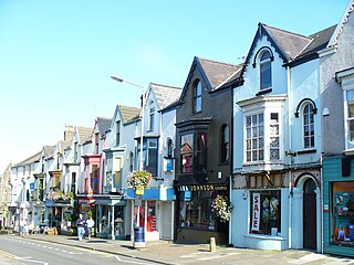
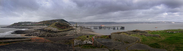
Oystermouth is a village in the district of Mumbles, Swansea, Wales. It is part of the Mumbles community.
The history of Swansea covers a period of continuous occupation stretching back a thousand years, while there is archaeological evidence of prehistoric human occupation of the surrounding area for thousands of years before that.
The M4 corridor is an area in the United Kingdom adjacent to the M4 motorway, which runs from London to South Wales. It is a major hi-tech hub. Important cities and towns linked by the M4 include London, Slough, Bracknell, Maidenhead, Reading, Newbury, Swindon, Bath, Bristol, Newport, Cardiff, Port Talbot and Swansea. The area is also served by the Great Western Main Line, the South Wales Main Line, and London Heathrow Airport. Technology companies with major operations in the area include Adobe, Amazon, Citrix Systems, Dell, Huawei, Lexmark, LG, Microsoft, Novell, Nvidia, O2, Oracle, Panasonic, SAP, and Symantec.

Aberavon Beach, also known as Aberavon Sands, is a three-mile (5 km) stretch of sandy beach on the north-eastern edge of Swansea Bay in Port Talbot, Wales. With its high breaker waves, it is popular with surfers. Aberavon Beach was awarded Blue Flag status in December 2007 and features in the Good Beach Guide published by the Marine Conservation Society.
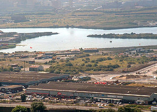
Swansea Docks is the collective name for several docks in Swansea, Wales, which are immediately south-east of Swansea city centre. In the mid-19th century, the port was exporting 60% of the world's copper from factories situated in the Tawe Valley. The working docks area today is owned and operated by Associated British Ports as the Port of Swansea, and the northern part around the Prince of Wales Dock is undergoing re-development into a new urban area branded as the SA1 Swansea Waterfront.

Baglan Bay is a part of the Swansea Bay coastline and a district of Neath Port Talbot county borough, Wales. Baglan Bay is also the name of a local government community. Baglan Bay is served by the M4 Motorway and the A48 road which traverse the northeastern edge of the area.
Crymlyn Burrows is an area in Wales to the east of Swansea city centre, and south of Crymlyn Bog. It is bounded by Jersey Marine Beach to the south and the River Neath to the east. The land west of Baldwin's Crescent falls within the City and County of Swansea and from Baldwin's Crescent eastwards falls within Neath Port Talbot. The area northwest of the Fabian Way contains a small settlement at Elba Crescent and Baldwins Crescent, and areas of industry and commerce.
The Port of Port Talbot is located on the River Afan estuary next to Port Talbot Steelworks in the industrial town of Port Talbot, South Wales. The whole basin complex covers about 500 acres (2.0 km2), consisting of: an inner set of floating docks, developed from 1834 onwards; and an outer tidal basin, completed in 1970. Owned and operated by Associated British Ports, the tidal basin has the deepest berthing facilities in the Severn estuary and is one of only a few harbours in the UK capable of handling Capesize vessels of up to 170,000 tonnes deadweight (DWT), mostly for the import of iron ore and coal for use by nearby Port Talbot Steelworks.
The Rhondda and Swansea Bay Railway was a Welsh railway company formed to connect the upper end of the Rhondda Fawr with Swansea, with the chief objective of transporting coal and other minerals to Swansea docks. It was incorporated in 1882, but at first the connection to Swansea from Briton Ferry was refused.

The A4241 Port Talbot Peripheral Distributor Road is a distributor road serving Port Talbot, Wales.
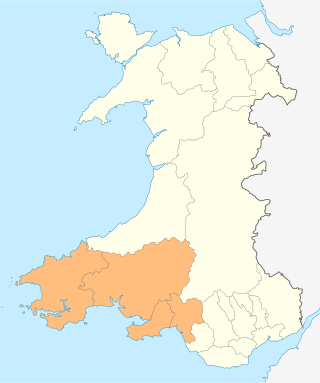
The Swansea Bay City Region, is a city region in Wales. It is a partnership between the local authorities of Carmarthenshire, Neath Port Talbot, Pembrokeshire and Swansea, local businesses in southwest Wales and other organisations with the support of the Welsh Government. The Swansea Bay City Region is coterminous with the area defined as South West Wales.

The coastline of Wales extends from the English border at Chepstow westwards to Pembrokeshire then north to Anglesey and back eastwards to the English border once again near Flint. Its character is determined by multiple factors, including the local geology and geological processes active during and subsequent to the last ice age, its relative exposure to or shelter from waves, tidal variation and the history of human settlement and development which varies considerably from one place to another. The majority of the coast east of Cardiff in the south, and of Llandudno in the north, is flat whilst that to the west is more typically backed by cliffs. The cliffs are a mix of sandstones, shales and limestones, the erosion of which provides material for beach deposits. Of the twenty-two principal areas which deliver local government in Wales, sixteen have a coastline, though that of Powys consists only of a short section of tidal river some distance from the open sea. Its length has been estimated at 1,680 miles (2,700 km).

In 2019, Wales generated 27% of its electricity consumption as renewable electricity, an increase from 19% in 2014. The Welsh Government set a target of 70% by 2030. In 2019, Wales was a net exporter of electricity. It produced 27.9 TWh of electricity while only consuming 14.7 TWh. The natural resource base for renewable energy is high by European standards, with the core sources being wind, wave, and tidal. Wales has a long history of renewable energy: in the 1880s, the first house in Wales with electric lighting powered from its own hydro-electric power station was in Plas Tan y Bwlch, Gwynedd. In 1963, the Ffestiniog Power Station was constructed, providing a large scale generation of hydroelectricity, and in November 1973, the Centre for Alternative Technology was opened in Machynlleth.