
Swansea is a coastal city and the second-largest city of Wales. It forms a principal area, officially known as the City and County of Swansea.

Cardiff Bay Barrage lies across the mouth of Cardiff Bay, Wales between Queen Alexandra Dock and Penarth Head. It was one of the largest civil engineering projects in Europe during construction in the 1990s.

Cardiff Bay is an area and freshwater lake in Cardiff, Wales. The site of a former tidal bay and estuary, it is the river mouth of the River Taff and Ely. The body of water was converted into a 500-acre (2.0 km2) lake as part of a UK Government redevelopment project, involving the damming of the rivers by the Cardiff Bay Barrage in 1999. The barrage impounds the rivers from the Severn Estuary, providing flood defence and the creation of a permanent non-tidal high water lake with limited access to the sea, serving as a core feature of the redevelopment of the area in the 1990s.

Bristol Harbour is the harbour in the city of Bristol, England. The harbour covers an area of 70 acres. It is the former natural tidal river Avon through the city but was made into its current form in 1809 when the tide was prevented from going out permanently. A tidal by-pass was dug for 2 miles through the fields of Bedminster for the river, known as the "River Avon New Cut", "New Cut", or simply "The Cut". It is often called the Floating Harbour as the water level remains constant and it is not affected by the state of the tide on the river in the Avon Gorge, The New Cut or the natural river southeast of Temple Meads to its source.

Marina Bay is a bay located in the Central Area of Singapore, surrounded by the perimeter of four other planning areas, the Downtown Core, Marina East, Marina South and Straits View. The area surrounding the bay itself, also called Marina Bay, is a 360 hectare extension to the adjacent Central Business District. It is also the new downtown of Singapore, built on Singapore's reclaimed land.

The River Tawe is a 30 miles (48 km) long river in South Wales. Its headwaters flow initially east from its source below Llyn y Fan Fawr south of Moel Feity in the Black Mountains, the westernmost range of the Brecon Beacons National Park, before the river turns south and then southwest to its estuary at Swansea. Its main tributaries are the right bank Upper and Lower Clydach Rivers and the Afon Twrch. The total area of the catchment is some 246 km2 (95 sq mi). The Tawe passes through a number of towns and villages including Ystradgynlais, Ystalyfera, Pontardawe, and Clydach and meets the sea at Swansea Bay below Swansea. The Tawe Valley is more commonly known as the Swansea Valley.
The history of Swansea covers a period of continuous occupation stretching back a thousand years, while there is archaeological evidence of prehistoric human occupation of the surrounding area for thousands of years before that.
Swansea city centre in Swansea, Wales, contains the main shopping, leisure and nightlife district in Swansea. The city centre covers much of the Castle ward including the area around Oxford Street, Castle Square, and the Quadrant Shopping Centre; Alexandra Road, High Street, Wind Street and the Castle; Parc Tawe; and the Maritime Quarter extending down to the seafront.
Glasgow Harbour in the following paragraphs is about a private sector urban regeneration scheme at Partick in the West End of the city of Glasgow, Scotland. It is not the history and development of the wider and internationally famous Glasgow Harbour from Glasgow Green to Clydebank which developed from the early 1800s and witnessed the birth and growth of modern shipbuilding and shipping.

The Swansea Canal was a canal constructed by the Swansea Canal Navigation Company between 1794 and 1798, running for 16.5 miles (26.6 km) from Swansea to Hen Neuadd, Abercraf in South Wales. It was steeply graded, and 36 locks were needed to enable it to rise 373 feet (114 m) over its length. The main cargos were coal, iron and steel, and the enterprise was profitable.
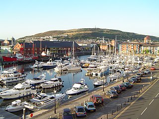
Swansea Marina is a marina in Swansea, south Wales, behind the barrage at the mouth of the River Tawe. There is a boatyard for building and servicing boats, and a few shops selling boating equipment.

The Swansea Museum in Swansea, Wales, UK is the oldest museum in Wales, created for and by the Royal Institution of South Wales in 1841 to house its collections and provide research and learning facilities.
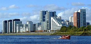
Swansea Docks is the collective name for several docks in Swansea, Wales, which are immediately south-east of Swansea city centre. In the mid-19th century, the port was exporting 60% of the world's copper from factories situated in the Tawe Valley. The working docks area today is owned and operated by Associated British Ports as the Port of Swansea, and the northern part around the Prince of Wales Dock is undergoing re-development into a new urban area branded as the SA1 Swansea Waterfront.

The Swansea barrage is a structure near the mouth of the River Tawe in Swansea, Wales. It was completed in 1992, creating a marina which extended the leisure boat facilities already being offered by the former South Dock.
National Cycle Network, Route 43 is part of the National Cycle Network and the Celtic Trail, which connects Swansea with Builth Wells. Most of the route is still awaiting development. As of June 2006, there is a 13-mile section out of Swansea that is open and signed.
Mermaid Quay is a waterfront shopping and leisure district in the Cardiff Bay area of Cardiff, Wales. The 14,000 m2 (150,000 sq ft) development was opened in 1999, and includes restaurants, bars, cafes and shops.

SA1 Swansea Waterfront is the marketing name given to the brownfield development area in the northern part of Swansea Docks, Wales. The area lies directly to the southeast of Swansea city centre. It is bordered by the Fabian Way to the north, and includes the Prince of Wales Dock.

The Ipswich Waterfront is a cultural and historically significant area surrounding the marina in the town of Ipswich, Suffolk, England. The modern dock was constructed in 1842 and the area was a functioning dock up until the 1970s. At the time of completion, the dock was known as 'the biggest and most important enclosed dock in the kingdom'. Although the dock as it stands was constructed in 1842, the area was used for trade as far back as the 7th century. The decline of industry in the town resulted in the area being transformed into a trendy area of Ipswich, the waterfront is now characterised by its marina, known as Neptune Marina, as well as its mix of classical and postmodern architecture which includes multiple high-rise apartment buildings, restaurants, bars and cafés. The waterfront is also home to the main campus of the region's university, the University of Suffolk.

Waterfront is a community and electoral ward in city of Swansea, Wales.


