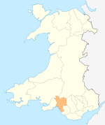
Aberavon was a constituency in Wales in the House of Commons of the Parliament of the United Kingdom. It was represented from 1922 until 2024 by the Welsh Labour Party. It included the town of Aberavon, although the largest town in the constituency was Port Talbot.

Port Talbot is a town and community in the county borough of Neath Port Talbot, Wales, situated on the east side of Swansea Bay, approximately eight miles from Swansea. The Port Talbot Steelworks covers a large area of land which dominates the south east of the town. It is one of the biggest steelworks in the world, but has been under threat of closure since the 1980s. The population was 31,550 in 2021, comprising about a fifth of the 141,931 population of Neath Port Talbot.

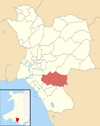
Neath Port Talbot is a county borough in the south-west of Wales. Its principal towns are Neath, Port Talbot, Briton Ferry and Pontardawe. The county borough borders Bridgend County Borough and Rhondda Cynon Taf to the east, Powys and Carmarthenshire to the north; and Swansea to the west.

Swansea Bay is a bay on the southern coast of Wales. The River Neath, River Tawe, River Afan, River Kenfig and Clyne River flow into the bay. Swansea Bay and the upper reaches of the Bristol Channel experience a large tidal range. The shipping ports in Swansea Bay are Swansea Docks, Port Talbot Docks and Briton Ferry wharves.

Aberavon is a town and community in Neath Port Talbot county borough, Wales. The town derived its name from being near the mouth of the river Afan, which also gave its name to a medieval lordship. Today it is essentially a district of Port Talbot, covering the central and south western part of the town. Aberavon is also the name of the nearby Blue Flag beach and the parish covering the same area.

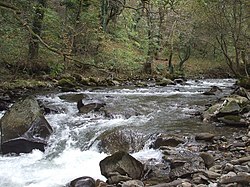
Pontrhydyfen is a small village in the Afan Valley, in Neath Port Talbot county borough in Wales. The village sits at the confluence of the River Afan and the smaller Afon Pelenna, 1.8 miles (2.9 km) north of the larger village of Cwmafan and not far from the towns of Port Talbot and Neath. The views from the village are dominated by the hills of Foel Fynyddau (370 m) to the west, Moel y Fen (260 m) to the south-east and Mynydd Pen-rhys (280 m) to the north. This former coal mining community is distinguished by two large 19th-century bridges that span the valley: a railway viaduct and a former aqueduct, known in the Welsh language as Y Bont Fawr. The built-up area has a population of around 830. It is in the community of Pelenna. There is both a Community Centre and rugby union club, Pontrhydyfen RFC.

Crynant is a village and community in the Dulais Valley in Wales. It lies 7¾ miles north-east from the town of Neath in Neath Port Talbot, situated between the mountains of Mynydd Marchywel to the west, Hirfynydd to the east and Mynydd y Drum to the north.

Port Talbot was one of the four local government districts of the county of West Glamorgan, Wales from 1974 to 1996. The borough was initially called Afan, changing its name to Port Talbot in 1986.

Bryn is a village and community in Neath Port Talbot County Borough in Wales. It has a population of 913. The village is located in the hills between Cwmafan, in the Afan Valley, and Maesteg in the Llynfi Valley, approximately 6 miles (9.7 km) from Port Talbot and 2 miles (3.2 km) from Maesteg. The name of the village now familiarly 'Bryn', is Bryntroedygam. So wrote the first vicar of St Theodore's in Port Talbot. There was a farm situated above Meadow Row named Bryn-Troed-y-Garn as shown on the 1876 OS map, as many more immigrants came to 'Bryntroedygam' it seemed the name of the village was to be shorted to Bryn. 12% of the village speak Welsh. The population rose to 923 by 2011.

Cwmafan, also known as Cwmavon, is a large village and community in the Afan valley in Wales, lying within Neath Port Talbot County Borough. It had a population of 5,603 in 2001, increasing slightly to 5,615 at the 2011 Census. Cwmafan is known for having a high percentage of Welsh speakers. In many ways it is a suburb of the nearby town of Port Talbot which is less than 2 miles (3 km) to the south. The literal translation of Cwmafan from Welsh to English is complex, Cwm means valley with Afan as the name of the river flowing through, hence the village residing within the Afan Valley. It could be a version of Afon which means river, so literally the "River Valley", this is common in Wales and the UK with many rivers being called Afon or Avon. There is also a Saint Afan, which it is possible the river was named after. There have been other suggestions but none accepted locally.
Cymmer is a small village in the community of Cymer and Glyncorrwg, in Neath Port Talbot in Wales, set on a hillside in the Afan Valley near the confluence of the River Afan and the River Corrwg. In 2001, Cymmer had a population of 2,883.
Bryn and Cwmavon is an electoral ward of Neath Port Talbot county borough, south Wales. The electoral ward comprises the parishes of Bryn and Cwmavon.

Glyncorrwg is a village in the Afan Valley, in southern Wales.
The South Wales Mineral Railway was a railway built to serve collieries in the upper Afan Valley, and bring their output to a dock at Briton Ferry, in South Wales. It opened in stages, in 1861 and 1863. It was built on the broad gauge and had steep gradients, including a rope worked incline near Briton Ferry.
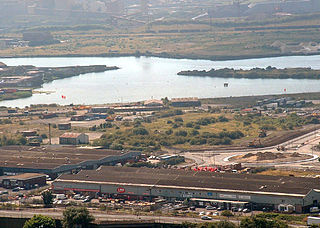
The Port of Port Talbot is located on the River Afan estuary next to Port Talbot Steelworks in the industrial town of Port Talbot, South Wales. The whole basin complex covers about 500 acres (2.0 km2), consisting of: an inner set of floating docks, developed from 1834 onwards; and an outer tidal basin, completed in 1970. Owned and operated by Associated British Ports, the tidal basin has the deepest berthing facilities in the Severn estuary and is one of only a few harbours in the UK capable of handling Capesize vessels of up to 170,000 tonnes deadweight (DWT), mostly for the import of iron ore and coal for use by nearby Port Talbot Steelworks.
The Rhondda and Swansea Bay Railway was a Welsh railway company formed to connect the upper end of the Rhondda Fawr with Swansea, with the chief objective of transporting coal and other minerals to Swansea docks. It was incorporated in 1882, but at first the connection to Swansea from Briton Ferry was refused.
Croeserw is a village of approximately 1,380 inhabitants in Gwynfi and Croeserw, Neath Port Talbot county borough, Wales.

Afon Clun is a 14-mile (23 km) long tributary of the River Ely, in the counties of Cardiff and Rhondda Cynon Taf, Wales. Its bedrock is predominantly of sandstone. Beginning on the western slope of The Garth the river is fast-flowing, in clear shallow water with a hard substrate, flowing to the south of Llantrisant and generally west to its confluence with the River Ely at Pontyclun, falling 715 feet (218 m) over its course.

Pelenna is a community in Neath Port Talbot, Wales. It largely covers the valleys of the rivers Pelenna and the Blaenpelenna, to the east of the town of Neath.
The Glyncorrwg Mineral Railway, later known as ‘Parsons’ Folly’, was constructed between 1839 and 1842 to transport coal from mines in the hinterland of Port Talbot in the south Wales coalfield to the Neath Canal at Aberdulais. Ownership changed several times and it was finally abandoned in 1852. Much of the route can still be followed and significant civil engineering features remain.