River Llynfi

Last updated

River Llynfi
River Llynfi - geograph.org.uk - 53546.jpg
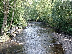
River Llynfi. From the bridge at Pont Rhyd-y-cyff
Native nameAfon Llynfi (Welsh)
Location
Country Wales
Cities Blackmill, Brynmenyn
Physical characteristics
Source 
  locationCraig Ogwr
Mouth  
  location
Aberkenfig
Basin features
Tributaries 
  leftNant Cwm-du, Nant Cedfyw
  rightNant Crynwydd, Nant Sychbant, Nant y Gadlys

The River Llynfi (Welsh : Afon Llynfi), [1] is one of three main tributaries of the River Ogmore (Welsh : Afon Ogwr).

It runs for around 10 miles from its source north of Maesteg and flows generally southwards through the Llynfi Valley to the confluence with the River Ogmore and the River Garw at Aberkenfig. Its main tributaries are Nant Cwm-du and Nant Cedfyw which enter on its left bank and Nant Crynwydd, Nant Sychbant and Nant y Gadlys on its right bank. [2]

The Llynfi has endured a long period of industrialisation and coal mining especially around Maesteg. There was an ironworks and brick works at Tondu.

Industrialisation and poor provision of sewerage led to severe water pollution of the river. In the second half of the 20th century, whilst the impact of coal mining diminished, new industries such as cosmetics and toiletries, paper making and sewage disposal continued to maintain the Llynfi in an almost abiotic condition. Strong enforcement action against a number of industries helped to ensure a steady improvement in quality into the 21st century.

Related Research Articles

<span class="mw-page-title-main">River Afan</span> River in Wales

The River Afan is a river in Wales whose valley formed the territory of the medieval Lords of Afan. The Afan Valley encompasses the upper reaches of the river. The valley is traversed by the A4107 road. Settlements in the area include Cwmafan, Pontrhydyfen and Cymmer. The town of Aberavon, whose name in Welsh Aberafan means 'mouth of the Afan', grew up on the banks of the river and was later subsumed by the town of Port Talbot.

<span class="mw-page-title-main">Maesteg</span> Human settlement in Wales

Maesteg is a town and community in Bridgend County Borough, Wales. Maesteg lies at the northernmost end of the Llynfi Valley, close to the border with Neath Port Talbot. In 2011, Maesteg had a population of 20,612. The English translation of Maesteg is 'fair field'.

<span class="mw-page-title-main">Bridgend County Borough</span> County borough in Wales

Bridgend County Borough is a county borough in the south-east of Wales. The county borough has a total population of 139,200 people, and contains the town of Bridgend, after which it is named. Its members of the Senedd are Sarah Murphy MS, representing the Bridgend Constituency, and Huw Irranca-Davies MS representing the Ogmore Constituency, and its members of UK parliament are Jamie Wallis and Chris Elmore.

<span class="mw-page-title-main">River Ogmore</span> River in Wales

The River Ogmore is a river in South Wales that is popular with anglers. It runs generally from north to south from the Ogmore Vale and Gilfach Goch, past Bridgend and Ogmore. The River Ogmore rises at Craig Ogwr in the Ogmore Valley as the Ogwr Fawr before it links with the Ogwr Fach at Blackmill. The River Llynfi, the River Garw and finally the River Ewenny in its estuary are all tributaries of the Ogmore which flows into the sea between Ogmore-by-Sea and the Merthyr Mawr sand-dunes.

<span class="mw-page-title-main">Ogwr</span>

The Borough of Ogwr was one of six districts of Mid Glamorgan in Wales, which existed from 1974 to 1996.

<span class="mw-page-title-main">Ogmore Castle</span>

Ogmore Castle is a Grade I listed castle ruin located near the village of Ogmore-by-Sea, south of the town of Bridgend in Glamorgan, South Wales. It is situated on the south bank of the River Ewenny and the east bank of the River Ogmore.

<span class="mw-page-title-main">Tondu</span> Human settlement in Wales

Tondu is a village in Bridgend County Borough, Wales, located about 3 miles (4.8 km) north of the town of Bridgend, in the community of Ynysawdre.

<span class="mw-page-title-main">South Wales Valleys</span> Group of industrialised peri-urban valleys in South Wales

The South Wales Valleys are a group of industrialised peri-urban valleys in South Wales. Most of the valleys run north–south, roughly parallel to each other. Commonly referred to as "The Valleys", they stretch from Carmarthenshire in the west to Monmouthshire in the east; to the edge of the pastoral country of the Vale of Glamorgan and the coastal plain near the cities of Swansea, Cardiff, and Newport.

<span class="mw-page-title-main">River Garw</span>

The River Garw runs for about 12 miles from its source in the hills north of Blaengarw to the confluence with the River Ogmore and the River Llynfi at Aberkenfig. It is one of three main tributaries of the River Ogmore which runs through the town of Bridgend. It is in Wales, United Kingdom.

<span class="mw-page-title-main">River Rhondda</span>

The River Rhondda is a river in South Wales with two major tributaries, Rhondda Fawr and Rhondda Fach.

<span class="mw-page-title-main">River Cynon</span>

The River Cynon in South Wales is a main tributary of the Taff. Its source is the rising of Llygad Cynon at 219 m (719 ft) above sea level at Penderyn, Rhondda Cynon Taf and flows roughly southeast, into the Taff at Abercynon in the same district. The water emerging at Llygad Cynon has been traced back to the sink of the Nant Cadlan at Ogof Fawr.

<span class="mw-page-title-main">Ewenny River</span> River in United Kingdom, Wales

The Ewenny River is a river in South Wales. For most of its 10 miles (16 km) length, it forms the border between the Vale of Glamorgan and Bridgend. It is a major tributary of the River Ogmore, which it joins near its estuary.

<span class="mw-page-title-main">Gilfach Goch</span> Human settlement in Wales

Gilfach Goch is a community, electoral ward and small former coal mining village mostly in the Borough of Rhondda Cynon Taf, south Wales, near the larger community of Tonyrefail. Some areas in the North Western part of the village lie within Bridgend County Borough. It is situated in the Cwm Ogwr Fach between the Cwm Ogwr Fawr to the west and the Cwm Rhondda to the east.

<span class="mw-page-title-main">Nant-y-moel</span> Human settlement in Bridgend County Borough, Wales

Nant-y-moel or Nantymoel[nant ə mɔi̯l] is a village and includes the formerly separate village of Pricetown in the county borough of Bridgend, Wales on the River Ogmore, and is one of the constituent villages of the Ogmore Valley. It is bordered by the village of Wyndham to the south and by the Bwlch y Clawdd mountain to the north.

<span class="mw-page-title-main">Afon Clun</span> River in Wales

The Afon Clun is a 14-mile (23 km) long tributary of the River Ely, in the counties of Cardiff and Rhondda Cynon Taf, Wales. Its bedrock is predominantly of sandstone. Beginning on the western slope of The Garth the river is fast-flowing, in clear shallow water with a hard substrate, flowing to the south of Llantrisant and generally west to its confluence with the River Ely at Pontyclun, falling 715 feet (218 m) over its course.

The Nant Gwys is a river flowing off the Black Mountain in Powys, Wales. Its tributaries Gwys Fawr and the Gwys Fach flow south from Banwen Gwyn and Bwlch y Ddeuwynt respectively and join forces to form the Nant Gwys proper which then flows for about 5 km / 3 mi to its confluence with the Afon Twrch at Cwm-twrch-Uchaf.

<span class="mw-page-title-main">Ogmore Valley</span> Human settlement in Wales

Ogmore Valley is a community in the Bridgend County Borough, Mid Glamorgan, Wales. Made up of the villages of Nantymoel, Ogmore Vale, Price Town and Wyndham, its population at the time of the 2001 census was 7,800, increasing to 7,954 at the 2011 Census. The ribbon housing of the valley follows the Ogwr Fawr tributary which rises at Craig Ogwr and joins the Ogwr Fach at Blackmill. Villages include Nantymoel, Price Town, Wyndham, Ogmore Vale, Lewistown, Pant-yr-awel and Blackmill.

<span class="mw-page-title-main">Garth, Bridgend</span> Human settlement in Wales

Garth is a village in Bridgend County Borough, Wales. Garth is situated to the east of the town of Maesteg, and lies at the northernmost end of the Llynfi Valley. During the 19th century Garth was an industrial coal-mining village which contained its own colliery, the Garth Merthyr Colliery.

References

  1. picture
  2. Ordnance Survey Explorer maps 151 'Cardiff & Bridgend/Caerdydd & Phen-y-bont-ar-Ogwr' and 166 'Rhondda & Merthyr Tydfil/Merthyr Tudful'

Coordinates: 51°32′37″N3°35′29″W / 51.54361°N 3.59139°W / 51.54361; -3.59139